
Station 4N NJ11 - 4N-NJ11
Network: 4N - 4N - New Jersey 2024 Earthquake Sequence (New Jersey 2024 Earthquake Sequence)
Nearby stations (2 deg radius)
| Station | Name | (Lat, Lon) | Start / End | Elevation |
| NJ11 | 4N-NJ11 | (40.59, -74.76) | 2024-04-11 / 2025-12-31 | 73 m |
| Crust2 Type: | Q5,orogen/36km no ice, Andes, 3 km seds. |
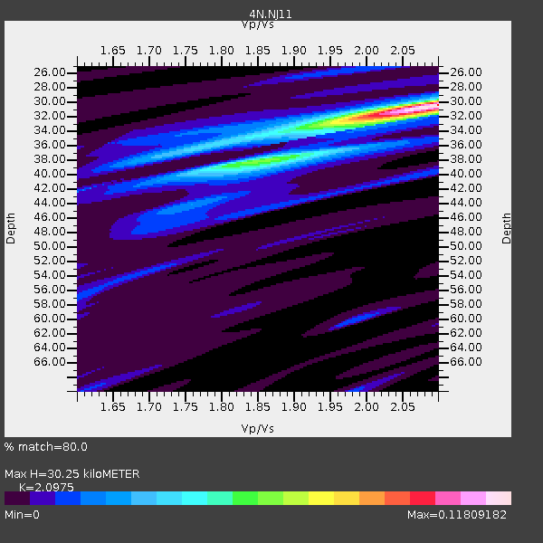
| Thickness Estimate: | 30 km |
| Thickness StdDev: | 3.1 km |
| Vp/Vs Estimate: | 2.10 |
| Vp/Vs StdDev: | 0.09 |
| Vs Estimate: | 2.996 km/s |
| Poisson's Ratio: | 0.35 |
| Peak Value: | 0.12 |
| Assumed Vp: | 6.283 km/s |
| Ps Weight: | 0.33333334 |
| PpPs Weight: | 0.33333334 |
| PsPs Weight: | 0.33333328 |
| Residual Complexity: | 0.554 |
| Nearby stations H: | +- |
| (2.0 deg) Vp/Vs: | +- |
1 with match > 90% ( 7.6923075 %) and 2 with match > 80% ( 15.384615 %) out of 13.
Download stack as xyz text file.
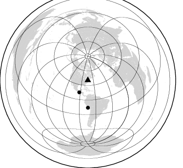
Azimuth Distribution of Events:
Prior Results for this Station
| Study | Thickness | Vp/Vs | Vp | Vs | Poissons Ratio | Extra |
| EARS | 30 km | 2.10 | 6.283 km/s | 2.996 km/s | 0.35 | |
| Crust2.0 | 36 km | 1.76 | 6.283 km/s | 3.569 km/s | 0.26 | Q5,orogen/36km no ice, Andes, 3 km seds. |
| Global Maxima | 30 km | 2.10 | 6.283 km/s | 2.996 km/s | 0.35 | amp=0.11809182 |
| Local Maxima 1 | 38 km | 1.82 | 6.283 km/s | 3.462 km/s | 0.28 | amp=0.050388455 |
| Local Maxima 2 | 32 km | 2.00 | 6.283 km/s | 3.142 km/s | 0.33 | amp=0.037569918 |
| Local Maxima 3 | 36 km | 1.75 | 6.283 km/s | 3.585 km/s | 0.26 | amp=0.02929699 |
| Local Maxima 4 | 25 km | 2.02 | 6.283 km/s | 3.118 km/s | 0.34 | amp=0.01685925 |
| Predicted Arrivals for vertical incidence (zero ray parameter) | |
| Ps | 5.28 SECOND |
| PpPs | 14.91 SECOND |
| PsPs/PpSs | 20.20 SECOND |
Events Processed for this Station
Download zip of receiver functions as SAC
Plot maxima for each earthquake.
Events Used in the Stack
(2 events)| Radial Match | Distance | Baz | FERegion | Time | Lat/Lon | Depth | Magnitude |
| 94.86432 | 56.1 deg | 179.636 deg | Near Coast Of Peru | 2024/06/28 05:36:37 UTC | (-15.8, -74.4) | 28 km | 7.2 mww |
| 84.54238 | 30.2 deg | 215.572 deg | Near Coast Of Chiapas, Mexico | 2024/05/12 11:39:14 UTC | (14.5, -92.4) | 75 km | 6.4 mww |
Losers
(11 events)| Radial Match | Distance | Baz | FERegion | Time | Lat/Lon | Depth | Magnitude | Reason |
| 71.4995 | 40.9 deg | 226.196 deg | Northern East Pacific Rise | 2024/06/12 02:25:56 UTC | (8.4, -103.3) | 10 km | 5.7 Mww | |
| 62.45005 | 56.2 deg | 179.746 deg | Near Coast Of Peru | 2024/06/16 14:47:31 UTC | (-15.9, -74.5) | 20 km | 6.0 mww | |
| 57.795403 | 91.0 deg | 131.074 deg | Southern Mid-Atlantic Ridge | 2024/06/14 04:26:48 UTC | (-30.9, -13.5) | 10 km | 5.9 Mww | |
| 56.465847 | 44.3 deg | 182.73 deg | Northern Peru | 2024/06/18 02:22:09 UTC | (-3.9, -76.7) | 100 km | 5.5 Mww | |
| 55.97575 | 31.6 deg | 156.793 deg | Near Coast Of Venezuela | 2024/06/23 03:58:00 UTC | (10.8, -62.6) | 87 km | 6.0 mww | |
| 47.722897 | 97.0 deg | 334.862 deg | Near West Coast Of Honshu, Japan | 2024/06/02 21:31:38 UTC | (37.5, 137.2) | 4.8 km | 5.8 mww | |
| 47.166744 | 59.1 deg | 119.159 deg | Central Mid-Atlantic Ridge | 2024/06/21 20:53:10 UTC | (0.8, -26.2) | 10 km | 5.5 Mww | |
| 44.99656 | 82.3 deg | 334.03 deg | Sea Of Okhotsk | 2024/06/06 11:07:53 UTC | (50.1, 147.6) | 622 km | 5.9 mww | |
| 44.016243 | 56.4 deg | 179.766 deg | Near Coast Of Peru | 2024/06/29 07:05:32 UTC | (-16.0, -74.6) | 18 km | 6.1 mww | |
| 35.524334 | 79.6 deg | 195.992 deg | West Chile Rise | 2024/06/04 18:32:59 UTC | (-37.3, -94.6) | 10 km | 5.5 Mww | |
| 29.692335 | 79.1 deg | 196.713 deg | West Chile Rise | 2024/06/04 18:32:56 UTC | (-36.6, -95.3) | 10 km | 5.5 Mwb |

