
Station 4N NJ12 - 4N-NJ12
Network: 4N - 4N - New Jersey 2024 Earthquake Sequence (New Jersey 2024 Earthquake Sequence)
Nearby stations (2 deg radius)
| Station | Name | (Lat, Lon) | Start / End | Elevation |
| NJ12 | 4N-NJ12 | (40.58, -74.86) | 2024-04-11 / 2025-12-31 | 70 m |
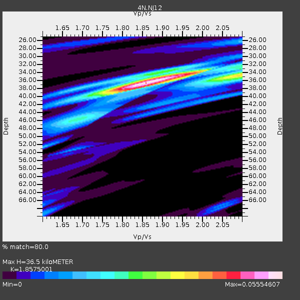
| Crust2 Type: | Q5,orogen/36km no ice, Andes, 3 km seds. |
| Thickness Estimate: | 36 km |
| Thickness StdDev: | 13 km |
| Vp/Vs Estimate: | 1.86 |
| Vp/Vs StdDev: | 0.12 |
| Vs Estimate: | 3.383 km/s |
| Poisson's Ratio: | 0.30 |
| Peak Value: | 0.06 |
| Assumed Vp: | 6.283 km/s |
| Ps Weight: | 0.33333334 |
| PpPs Weight: | 0.33333334 |
| PsPs Weight: | 0.33333328 |
| Residual Complexity: | 0.574 |
| Nearby stations H: | +- |
| (2.0 deg) Vp/Vs: | +- |
1 with match > 90% ( 9.090909 %) and 2 with match > 80% ( 18.181818 %) out of 11.
Download stack as xyz text file.
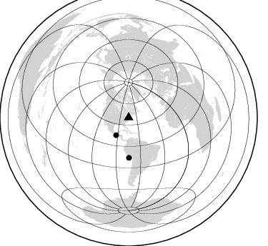
Azimuth Distribution of Events:
Prior Results for this Station
| Study | Thickness | Vp/Vs | Vp | Vs | Poissons Ratio | Extra |
| EARS | 36 km | 1.86 | 6.283 km/s | 3.383 km/s | 0.30 | |
| Crust2.0 | 36 km | 1.76 | 6.283 km/s | 3.569 km/s | 0.26 | Q5,orogen/36km no ice, Andes, 3 km seds. |
| Global Maxima | 36 km | 1.86 | 6.283 km/s | 3.383 km/s | 0.30 | amp=0.05554607 |
| Local Maxima 1 | 35 km | 2.09 | 6.283 km/s | 3.006 km/s | 0.35 | amp=0.03237666 |
| Local Maxima 2 | 34 km | 1.97 | 6.283 km/s | 3.194 km/s | 0.33 | amp=0.0309093 |
| Local Maxima 3 | 39 km | 1.79 | 6.283 km/s | 3.52 km/s | 0.27 | amp=0.019084036 |
| Local Maxima 4 | 26 km | 2.10 | 6.283 km/s | 2.996 km/s | 0.35 | amp=0.014452048 |
| Predicted Arrivals for vertical incidence (zero ray parameter) | |
| Ps | 4.98 SECOND |
| PpPs | 16.60 SECOND |
| PsPs/PpSs | 21.58 SECOND |
Events Processed for this Station
Download zip of receiver functions as SAC
Plot maxima for each earthquake.
Events Used in the Stack
(2 events)| Radial Match | Distance | Baz | FERegion | Time | Lat/Lon | Depth | Magnitude |
| 95.57692 | 56.1 deg | 179.518 deg | Near Coast Of Peru | 2024/06/28 05:36:37 UTC | (-15.8, -74.4) | 28 km | 7.2 mww |
| 82.010506 | 30.2 deg | 215.415 deg | Near Coast Of Chiapas, Mexico | 2024/05/12 11:39:14 UTC | (14.5, -92.4) | 75 km | 6.4 mww |
Losers
(9 events)| Radial Match | Distance | Baz | FERegion | Time | Lat/Lon | Depth | Magnitude | Reason |
| 67.41251 | 62.5 deg | 316.329 deg | Fox Islands, Aleutian Islands | 2024/05/19 09:35:24 UTC | (52.2, -170.9) | 28 km | 6.0 mww | |
| 61.387684 | 91.3 deg | 131.115 deg | Southern Mid-Atlantic Ridge | 2024/06/14 09:51:57 UTC | (-31.2, -13.3) | 10 km | 5.9 mww | |
| 54.307156 | 56.2 deg | 179.628 deg | Near Coast Of Peru | 2024/06/16 14:47:31 UTC | (-15.9, -74.5) | 20 km | 6.0 mww | |
| 51.956326 | 57.5 deg | 334.214 deg | Near N. Coast Of Eastern Siberia | 2024/05/06 11:11:57 UTC | (68.0, -177.6) | 9.3 km | 5.3 Mww | |
| 44.240086 | 44.3 deg | 182.585 deg | Northern Peru | 2024/06/18 02:22:09 UTC | (-3.9, -76.7) | 100 km | 5.5 Mww | |
| 41.354214 | 82.3 deg | 333.974 deg | Sea Of Okhotsk | 2024/06/06 11:07:53 UTC | (50.1, 147.6) | 622 km | 5.9 mww | |
| 40.924057 | 40.8 deg | 226.083 deg | Northern East Pacific Rise | 2024/06/12 02:25:56 UTC | (8.4, -103.3) | 10 km | 5.7 Mww | |
| 37.79008 | 79.0 deg | 196.634 deg | West Chile Rise | 2024/06/04 18:32:56 UTC | (-36.6, -95.3) | 10 km | 5.5 Mwb | |
| 34.61701 | 97.0 deg | 334.786 deg | Near West Coast Of Honshu, Japan | 2024/06/02 21:31:38 UTC | (37.5, 137.2) | 4.8 km | 5.8 mww |

