
Station 4N NJ14 - Wayne Proerty
Network: 4N - 4N - New Jersey 2024 Earthquake Sequence (New Jersey 2024 Earthquake Sequence)
Nearby stations (2 deg radius)
| Station | Name | (Lat, Lon) | Start / End | Elevation |
| NJ14 | Wayne Proerty | (40.69, -74.76) | 2024-04-10 / 2025-12-31 | 158 m |
| Crust2 Type: | Q5,orogen/36km no ice, Andes, 3 km seds. |
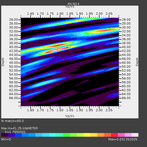
| Thickness Estimate: | 41 km |
| Thickness StdDev: | 4.1 km |
| Vp/Vs Estimate: | 1.79 |
| Vp/Vs StdDev: | 0.15 |
| Vs Estimate: | 3.52 km/s |
| Poisson's Ratio: | 0.27 |
| Peak Value: | 0.05 |
| Assumed Vp: | 6.283 km/s |
| Ps Weight: | 0.33333334 |
| PpPs Weight: | 0.33333334 |
| PsPs Weight: | 0.33333328 |
| Residual Complexity: | 0.778 |
| Nearby stations H: | 41 km +- 1.4 km |
| (2.0 deg) Vp/Vs: | 1.82 +- 0.06 |
2 with match > 90% ( 18.181818 %) and 3 with match > 80% ( 27.272728 %) out of 11.
Download stack as xyz text file.
Azimuth Distribution of Events:

Prior Results for this Station
| Study | Thickness | Vp/Vs | Vp | Vs | Poissons Ratio | Extra |
| EARS | 41 km | 1.79 | 6.283 km/s | 3.52 km/s | 0.27 | |
| Crust2.0 | 36 km | 1.76 | 6.283 km/s | 3.569 km/s | 0.26 | Q5,orogen/36km no ice, Andes, 3 km seds. |
| Global Maxima | 41 km | 1.79 | 6.283 km/s | 3.52 km/s | 0.27 | amp=0.051352005 |
| Local Maxima 1 | 31 km | 2.02 | 6.283 km/s | 3.107 km/s | 0.34 | amp=0.03833433 |
| Local Maxima 2 | 27 km | 1.87 | 6.283 km/s | 3.369 km/s | 0.30 | amp=0.034503847 |
| Local Maxima 3 | 40 km | 1.75 | 6.283 km/s | 3.59 km/s | 0.26 | amp=0.03302258 |
| Local Maxima 4 | 42 km | 1.61 | 6.283 km/s | 3.897 km/s | 0.19 | amp=0.023344658 |
| Predicted Arrivals for vertical incidence (zero ray parameter) | |
| Ps | 5.15 SECOND |
| PpPs | 18.28 SECOND |
| PsPs/PpSs | 23.44 SECOND |
Events Processed for this Station
Download zip of receiver functions as SAC
Plot maxima for each earthquake.
Events Used in the Stack
(3 events)| Radial Match | Distance | Baz | FERegion | Time | Lat/Lon | Depth | Magnitude |
| 97.01 | 56.2 deg | 179.639 deg | Near Coast Of Peru | 2024/06/28 05:36:37 UTC | (-15.8, -74.4) | 28 km | 7.2 mww |
| 90.79161 | 30.3 deg | 215.476 deg | Near Coast Of Chiapas, Mexico | 2024/05/12 11:39:14 UTC | (14.5, -92.4) | 75 km | 6.4 mww |
| 81.52912 | 31.7 deg | 156.861 deg | Near Coast Of Venezuela | 2024/06/23 03:58:00 UTC | (10.8, -62.6) | 87 km | 6.0 mww |
Losers
(8 events)| Radial Match | Distance | Baz | FERegion | Time | Lat/Lon | Depth | Magnitude | Reason |
| 72.72591 | 41.0 deg | 226.116 deg | Northern East Pacific Rise | 2024/06/12 02:25:56 UTC | (8.4, -103.3) | 10 km | 5.7 Mww | |
| 69.632935 | 62.0 deg | 173.601 deg | Chile-Bolivia Border Region | 2024/06/01 10:53:06 UTC | (-21.4, -68.7) | 99 km | 5.1 Mww | |
| 68.510056 | 62.5 deg | 316.324 deg | Fox Islands, Aleutian Islands | 2024/05/19 09:35:24 UTC | (52.2, -170.9) | 28 km | 6.0 mww | |
| 62.650803 | 44.4 deg | 182.728 deg | Northern Peru | 2024/06/18 02:22:09 UTC | (-3.9, -76.7) | 100 km | 5.5 Mww | |
| 60.01876 | 56.3 deg | 179.749 deg | Near Coast Of Peru | 2024/06/16 14:47:31 UTC | (-15.9, -74.5) | 20 km | 6.0 mww | |
| 57.258602 | 91.3 deg | 131.18 deg | Southern Mid-Atlantic Ridge | 2024/06/14 09:51:57 UTC | (-31.2, -13.3) | 10 km | 5.9 mww | |
| 46.18137 | 59.2 deg | 119.214 deg | Central Mid-Atlantic Ridge | 2024/06/21 20:53:10 UTC | (0.8, -26.2) | 10 km | 5.5 Mww | |
| 45.883236 | 82.2 deg | 334.025 deg | Sea Of Okhotsk | 2024/06/06 11:07:53 UTC | (50.1, 147.6) | 622 km | 5.9 mww |

