
Station 7D J57A - SIO OBS J57A
Network: 7D - Cascadia Initiative Community Experiment-OBS component
Nearby stations (2 deg radius)
| Station | Name | (Lat, Lon) | Start / End | Elevation |
| J57A | SIO OBS J57A | (47.08, -124.45) | 2011-10-17 / 2012-07-15 | -55.8 m |
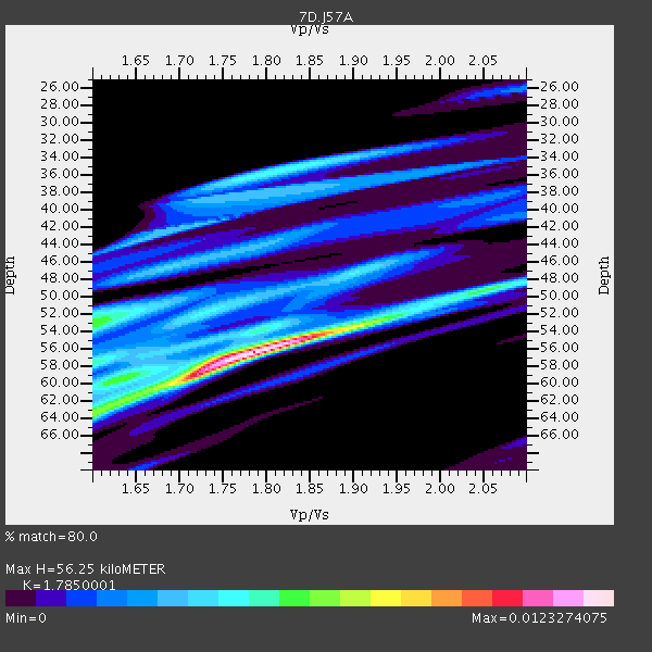
| Crust2 Type: | C3,continental shelf, 2 km seds. |
| Thickness Estimate: | 56 km |
| Thickness StdDev: | 9.2 km |
| Vp/Vs Estimate: | 1.79 |
| Vp/Vs StdDev: | 0.09 |
| Vs Estimate: | 3.436 km/s |
| Poisson's Ratio: | 0.27 |
| Peak Value: | 0.01 |
| Assumed Vp: | 6.134 km/s |
| Ps Weight: | 0.33333334 |
| PpPs Weight: | 0.33333334 |
| PsPs Weight: | 0.33333328 |
| Residual Complexity: | 0.742 |
| Nearby stations H: | +- |
| (2.0 deg) Vp/Vs: | +- |
0 with match > 90% ( 0.0 %) and 3 with match > 80% ( 11.538462 %) out of 26.
Download stack as xyz text file.
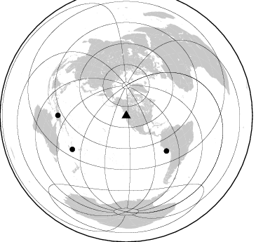
Azimuth Distribution of Events:
Prior Results for this Station
| Study | Thickness | Vp/Vs | Vp | Vs | Poissons Ratio | Extra |
| EARS | 56 km | 1.79 | 6.134 km/s | 3.436 km/s | 0.27 | |
| Crust2.0 | 31 km | 1.80 | 6.134 km/s | 3.406 km/s | 0.28 | C3,continental shelf, 2 km seds. |
| Global Maxima | 56 km | 1.79 | 6.134 km/s | 3.436 km/s | 0.27 | amp=0.0123274075 |
| Local Maxima 1 | 59 km | 1.71 | 6.134 km/s | 3.587 km/s | 0.24 | amp=0.0076124356 |
| Local Maxima 2 | 53 km | 1.60 | 6.134 km/s | 3.834 km/s | 0.18 | amp=0.0060701794 |
| Local Maxima 3 | 64 km | 1.60 | 6.134 km/s | 3.834 km/s | 0.18 | amp=0.0057445746 |
| Local Maxima 4 | 53 km | 1.92 | 6.134 km/s | 3.199 km/s | 0.31 | amp=0.005401707 |
| Predicted Arrivals for vertical incidence (zero ray parameter) | |
| Ps | 7.20 SECOND |
| PpPs | 25.54 SECOND |
| PsPs/PpSs | 32.74 SECOND |
Events Processed for this Station
Download zip of receiver functions as SAC
Plot maxima for each earthquake.
Events Used in the Stack
(3 events)| Radial Match | Distance | Baz | FERegion | Time | Lat/Lon | Depth | Magnitude |
| 89.05805 | 90.3 deg | 238.117 deg | Southeast Of Loyalty Islands | 2012/03/04 12:49:02 GMT | (-21.5, 169.8) | 14 km | 5.7 MW, 5.4 MS, 5.4 MB, 5.6 MW |
| 86.50213 | 97.4 deg | 270.225 deg | Irian Jaya, Indonesia | 2011/11/15 23:42:29 GMT | (-5.3, 140.3) | 12 km | 5.7 MB, 5.4 MS, 5.7 MW, 5.6 MW |
| 80.01828 | 76.1 deg | 131.219 deg | Near Coast Of Peru | 2012/07/11 20:52:37 GMT | (-15.3, -75.3) | 14 km | 5.6 MW |
Losers
(23 events)| Radial Match | Distance | Baz | FERegion | Time | Lat/Lon | Depth | Magnitude | Reason |
| 96.15241 | 97.4 deg | 293.174 deg | Negros, Philippines | 2012/02/06 11:33:21 GMT | (10.0, 123.3) | 10 km | 5.9 MW | |
| 93.98961 | 50.9 deg | 124.619 deg | Costa Rica | 2012/02/13 10:55:09 GMT | (9.2, -84.1) | 16 km | 5.6 MB, 5.5 MS, 5.9 MW, 5.7 MW | |
| 89.10947 | 77.9 deg | 227.036 deg | Tonga Islands | 2011/11/11 15:02:19 GMT | (-17.7, -173.1) | 10 km | 5.5 MB, 5.6 MW | |
| 87.72182 | 54.7 deg | 302.866 deg | Kuril Islands | 2011/11/19 22:06:00 GMT | (46.6, 151.5) | 96 km | 5.5 MB | |
| 87.447845 | 51.6 deg | 303.728 deg | Kuril Islands | 2012/06/09 14:23:20 GMT | (48.9, 154.9) | 49 km | 5.5 MW | |
| 86.57421 | 78.1 deg | 227.416 deg | Tonga Islands | 2012/01/05 01:13:40 GMT | (-17.7, -173.5) | 35 km | 5.6 MW | |
| 86.30926 | 76.2 deg | 286.914 deg | Mariana Islands Region | 2012/01/26 22:04:06 GMT | (21.6, 142.9) | 314 km | 5.5 MB, 5.3 MW | |
| 81.31631 | 43.4 deg | 311.68 deg | Near East Coast Of Kamchatka | 2012/06/24 03:15:01 GMT | (57.6, 163.2) | 10 km | 5.8 MB, 5.8 MS, 6.0 MW, 6.1 MW | |
| 79.45983 | 89.3 deg | 223.925 deg | Kermadec Islands Region | 2011/12/19 05:32:16 GMT | (-29.1, -176.9) | 10 km | 5.7 MW, 5.5 MW | |
| 76.981384 | 80.9 deg | 231.331 deg | Fiji Islands Region | 2012/02/10 01:47:34 GMT | (-18.0, -178.5) | 582 km | 6.0 MB, 5.9 MW, 6.0 MW | |
| 76.048355 | 54.8 deg | 125.6 deg | South Of Panama | 2012/06/04 03:15:24 GMT | (5.5, -82.6) | 7.0 km | 5.8 MB, 5.8 MS, 6.3 MW, 6.1 MW | |
| 75.276215 | 88.9 deg | 223.508 deg | Kermadec Islands Region | 2011/10/21 17:57:16 GMT | (-29.0, -176.2) | 33 km | 6.4 MB, 7.5 MS, 7.4 MW, 7.4 MW | |
| 74.74743 | 94.5 deg | 270.484 deg | Near N Coast Of New Guinea, P.N.G. | 2011/11/20 16:31:38 GMT | (-3.0, 142.1) | 10 km | 5.5 MW, 5.7 MW | |
| 72.27357 | 84.8 deg | 225.842 deg | South Of Tonga Islands | 2012/04/24 15:15:38 GMT | (-24.2, -175.9) | 10 km | 5.6 MW, 5.6 MW, 5.6 MS | |
| 68.99351 | 86.0 deg | 249.677 deg | Solomon Islands | 2012/07/03 03:49:33 GMT | (-10.8, 163.3) | 92 km | 5.6 MB, 5.5 MW, 5.5 MW | |
| 67.6818 | 95.4 deg | 299.536 deg | Luzon, Philippines | 2012/06/16 22:18:47 GMT | (15.6, 119.6) | 28 km | 5.9 MW, 5.7 MS, 5.9 MW, 6.1 MB | |
| 66.46773 | 35.4 deg | 137.086 deg | Guerrero, Mexico | 2011/12/11 01:47:25 GMT | (17.8, -100.0) | 54 km | 6.2 MB, 6.5 MW, 6.5 MW | |
| 64.79251 | 93.8 deg | 9.563 deg | Turkey | 2011/10/23 11:32:41 GMT | (38.8, 43.3) | 5.0 km | 5.7 MB, 5.5 ML | |
| 60.180603 | 89.4 deg | 261.599 deg | New Britain Region, P.N.G. | 2012/04/28 19:21:03 GMT | (-5.3, 152.1) | 35 km | 5.6 MW | |
| 55.340576 | 93.0 deg | 129.297 deg | Santiago Del Estero Prov., Arg. | 2012/03/05 07:46:10 GMT | (-28.2, -63.3) | 554 km | 6.0 MB, 6.1 MW, 6.1 MW | |
| 48.866127 | 87.2 deg | 251.615 deg | Solomon Islands | 2012/02/14 08:19:55 GMT | (-10.4, 161.1) | 51 km | 6.2 MB, 6.4 MW, 6.4 MW | |
| 47.598984 | 55.4 deg | 301.672 deg | Kuril Islands | 2012/07/11 02:31:16 GMT | (45.4, 151.4) | 10 km | 5.6 MB, 5.5 MS, 5.7 MW, 5.7 MW | |
| 43.24321 | 87.1 deg | 133.458 deg | Near Coast Of Northern Chile | 2011/10/30 18:53:43 GMT | (-25.7, -71.0) | 47 km | 5.7 MB, 5.4 MS, 5.7 MW, 5.8 MW |
