
Station 7D J68A - WHOI OBS ID S89
Network: 7D - Cascadia Initiative Community Experiment-OBS component
Nearby stations (2 deg radius)
| Station | Name | (Lat, Lon) | Start / End | Elevation |
| J68A | WHOI OBS ID S89 | (48.48, -127.83) | 2011-11-25 / 2012-05-19 | -2590.0 m |
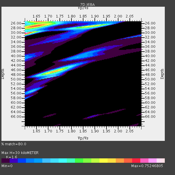
| Crust2 Type: | C2,continental shelf, 1 km seds. |
| Thickness Estimate: | 30 km |
| Thickness StdDev: | 12 km |
| Vp/Vs Estimate: | 1.60 |
| Vp/Vs StdDev: | 0.19 |
| Vs Estimate: | 3.9 km/s |
| Poisson's Ratio: | 0.18 |
| Peak Value: | 0.75 |
| Assumed Vp: | 6.24 km/s |
| Ps Weight: | 0.33333334 |
| PpPs Weight: | 0.33333334 |
| PsPs Weight: | 0.33333328 |
| Residual Complexity: | 0.785 |
| Nearby stations H: | +- |
| (2.0 deg) Vp/Vs: | +- |
0 with match > 90% ( 0.0 %) and 2 with match > 80% ( 6.060606 %) out of 33.
Download stack as xyz text file.
Azimuth Distribution of Events:

Prior Results for this Station
| Study | Thickness | Vp/Vs | Vp | Vs | Poissons Ratio | Extra |
| EARS | 30 km | 1.60 | 6.24 km/s | 3.9 km/s | 0.18 | |
| Crust2.0 | 30 km | 1.80 | 6.24 km/s | 3.467 km/s | 0.28 | C2,continental shelf, 1 km seds. |
| Global Maxima | 30 km | 1.60 | 6.24 km/s | 3.9 km/s | 0.18 | amp=0.75246805 |
| Local Maxima 1 | 25 km | 1.66 | 6.24 km/s | 3.765 km/s | 0.21 | amp=0.56087613 |
| Local Maxima 2 | 46 km | 1.72 | 6.24 km/s | 3.623 km/s | 0.25 | amp=0.54882455 |
| Local Maxima 3 | 27 km | 1.66 | 6.24 km/s | 3.759 km/s | 0.22 | amp=0.36340332 |
| Local Maxima 4 | 27 km | 1.89 | 6.24 km/s | 3.297 km/s | 0.31 | amp=0.33312443 |
| Predicted Arrivals for vertical incidence (zero ray parameter) | |
| Ps | 2.88 SECOND |
| PpPs | 12.50 SECOND |
| PsPs/PpSs | 15.38 SECOND |
Events Processed for this Station
Download zip of receiver functions as SAC
Plot maxima for each earthquake.
Events Used in the Stack
(2 events)| Radial Match | Distance | Baz | FERegion | Time | Lat/Lon | Depth | Magnitude |
| 85.73454 | 63.5 deg | 297.319 deg | Near East Coast Of Honshu, Japan | 2012/04/12 14:50:52 GMT | (37.5, 141.5) | 25 km | 5.5 MW, 5.6 MB |
| 80.32573 | 90.2 deg | 4.037 deg | Eastern Caucasus | 2012/05/07 04:40:27 GMT | (41.5, 46.8) | 11 km | 5.7 MB, 5.7 MS, 5.6 MW, 5.6 MW |
Losers
(31 events)| Radial Match | Distance | Baz | FERegion | Time | Lat/Lon | Depth | Magnitude | Reason |
| 87.528145 | 58.9 deg | 126.572 deg | Off Coast Of Central America | 2012/03/04 09:44:14 GMT | (2.7, -84.3) | 9.0 km | 5.5 MB, 5.5 MW | |
| 79.16182 | 86.9 deg | 159.818 deg | Southeast Of Easter Island | 2012/05/02 17:06:05 GMT | (-35.9, -102.7) | 10 km | 5.5 MW, 4.9 MS, 4.7 MB | |
| 74.834724 | 64.1 deg | 297.128 deg | Near East Coast Of Honshu, Japan | 2012/01/12 03:20:49 GMT | (37.0, 141.1) | 16 km | 6.0 MB, 5.2 MS, 5.5 MW, 5.5 MW | |
| 73.35975 | 94.1 deg | 268.898 deg | Irian Jaya, Indonesia | 2012/03/20 17:56:18 GMT | (-3.8, 140.3) | 66 km | 6.2 MB, 6.1 MW, 6.2 MW | |
| 69.561485 | 87.2 deg | 239.963 deg | Vanuatu Islands | 2012/02/03 03:46:21 GMT | (-17.4, 167.3) | 8.0 km | 5.9 MB, 5.8 MS, 6.1 MW, 6.1 MW | |
| 68.418915 | 65.4 deg | 296.377 deg | Near East Coast Of Honshu, Japan | 2012/04/24 20:22:10 GMT | (35.6, 140.5) | 54 km | 5.5 MW, 5.5 MW | |
| 65.46758 | 49.2 deg | 300.802 deg | Kuril Islands | 2012/04/23 22:40:22 GMT | (48.4, 154.7) | 31 km | 5.6 MW, 5.2 MS, 5.4 MB, 5.7 MW | |
| 65.26861 | 65.2 deg | 296.293 deg | Near East Coast Of Honshu, Japan | 2012/03/14 12:05:04 GMT | (35.7, 140.7) | 10 km | 5.7 MB, 5.6 MS, 6.0 MW | |
| 64.12106 | 87.3 deg | 237.142 deg | Vanuatu Islands | 2012/03/09 07:09:50 GMT | (-19.1, 169.6) | 16 km | 6.1 MB, 6.7 MS, 6.7 MW, 6.7 MW | |
| 63.892014 | 95.7 deg | 126.825 deg | Santiago Del Estero Prov., Arg. | 2012/03/05 07:46:10 GMT | (-28.2, -63.3) | 554 km | 6.0 MB, 6.1 MW, 6.1 MW | |
| 63.79447 | 38.0 deg | 133.734 deg | Guerrero, Mexico | 2011/12/11 01:47:25 GMT | (17.8, -100.0) | 54 km | 6.2 MB, 6.5 MW, 6.5 MW | |
| 63.54212 | 92.1 deg | 263.054 deg | New Guinea, Papua New Guinea | 2012/03/21 22:15:06 GMT | (-6.2, 146.0) | 118 km | 6.3 MB, 6.6 MW, 6.6 MW | |
| 61.562584 | 89.9 deg | 260.025 deg | New Britain Region, P.N.G. | 2012/02/02 09:32:16 GMT | (-6.6, 149.7) | 39 km | 5.6 MW | |
| 61.334793 | 92.7 deg | 291.899 deg | Luzon, Philippines | 2012/03/05 23:06:30 GMT | (12.4, 123.7) | 37 km | 5.6 MW | |
| 58.047215 | 92.1 deg | 265.837 deg | New Guinea, Papua New Guinea | 2012/03/19 13:42:34 GMT | (-4.4, 143.9) | 113 km | 5.6 MB, 5.3 MW, 5.3 MW | |
| 54.25486 | 75.8 deg | 227.772 deg | Samoa Islands Region | 2012/03/19 23:46:35 GMT | (-14.6, -175.7) | 28 km | 5.9 MW, 5.5 MB, 5.5 MS, 5.7 MW | |
| 53.822113 | 91.0 deg | 24.248 deg | Southern Greece | 2012/04/16 11:23:43 GMT | (36.6, 21.5) | 29 km | 5.8 MW, 5.7 MW | |
| 53.36204 | 87.4 deg | 259.055 deg | New Britain Region, P.N.G. | 2012/04/28 19:21:03 GMT | (-5.3, 152.1) | 35 km | 5.6 MW | |
| 52.490112 | 80.6 deg | 297.851 deg | Ryukyu Islands, Japan | 2012/02/27 19:31:51 GMT | (25.6, 127.1) | 42 km | 5.6 MB | |
| 48.58454 | 43.1 deg | 144.669 deg | Northern East Pacific Rise | 2012/03/26 18:12:52 GMT | (10.1, -104.2) | 10 km | 5.6 MB, 5.8 MS, 6.0 MW, 6.0 MW | |
| 47.156464 | 69.7 deg | 294.648 deg | Southeast Of Honshu, Japan | 2012/01/01 05:27:55 GMT | (31.5, 138.1) | 365 km | 6.2 MB, 6.8 MW, 6.8 MW | |
| 47.12725 | 80.1 deg | 223.366 deg | Tonga Islands | 2012/02/04 07:40:12 GMT | (-20.5, -174.0) | 8.0 km | 5.5 MB, 5.5 MS, 5.8 MW, 5.7 MW | |
| 46.636242 | 88.8 deg | 221.387 deg | Kermadec Islands Region | 2011/12/19 05:32:16 GMT | (-29.1, -176.9) | 10 km | 5.7 MW, 5.5 MW | |
| 45.41829 | 76.3 deg | 225.38 deg | Tonga Islands | 2011/12/26 04:48:08 GMT | (-16.2, -173.9) | 90 km | 5.8 MB, 6.0 MW, 6.0 MW | |
| 43.107418 | 85.9 deg | 258.545 deg | New Ireland Region, P.N.G. | 2012/04/06 16:15:58 GMT | (-4.6, 153.5) | 108 km | 5.5 MB, 6.1 MW, 6.1 MW | |
| 42.26321 | 92.4 deg | 261.478 deg | Eastern New Guinea Reg., P.N.G. | 2012/02/15 14:07:51 GMT | (-7.5, 147.0) | 8.0 km | 5.8 MB, 5.1 MS, 5.2 MW, 5.3 MW | |
| 42.160465 | 61.3 deg | 299.141 deg | Near East Coast Of Honshu, Japan | 2012/01/28 00:22:18 GMT | (40.2, 142.2) | 55 km | 5.6 MW, 5.5 MW, 5.6 MB | |
| 42.086754 | 89.8 deg | 259.998 deg | New Britain Region, P.N.G. | 2012/02/02 06:46:30 GMT | (-6.6, 149.8) | 51 km | 5.6 MW | |
| 39.827217 | 94.3 deg | 134.745 deg | Near Coast Of Central Chile | 2012/01/17 23:23:23 GMT | (-31.7, -71.6) | 34 km | 5.8 ML | |
| 32.3237 | 57.5 deg | 155.599 deg | Central East Pacific Rise | 2012/01/06 18:54:39 GMT | (-6.3, -107.3) | 10 km | 5.5 MW | |
| 30.730293 | 44.1 deg | 127.444 deg | Near Coast Of Chiapas, Mexico | 2012/01/21 18:47:11 GMT | (14.9, -93.0) | 45 km | 5.9 MB, 5.8 MS, 6.2 MW, 6.3 MW |
