
Station 8G EC02 - EC02
Network: 8G - 2016 Pedernales Earthquake Aftershock Deployment Ecuador
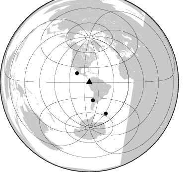
Nearby stations (2 deg radius)
| Station | Name | (Lat, Lon) | Start / End | Elevation |
| EC02 | EC02 | (0.98, -79.57) | 2016-05-01 / 2017-05-10 | 170 m |
| Crust2 Type: | T6,Margin /shield transition, 1 km seds. |
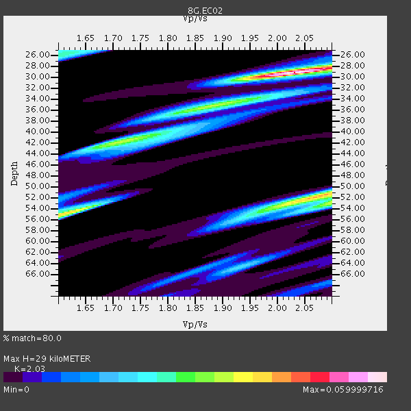
| Thickness Estimate: | 29 km |
| Thickness StdDev: | 5.0 km |
| Vp/Vs Estimate: | 2.03 |
| Vp/Vs StdDev: | 0.18 |
| Vs Estimate: | 3.188 km/s |
| Poisson's Ratio: | 0.34 |
| Peak Value: | 0.06 |
| Assumed Vp: | 6.472 km/s |
| Ps Weight: | 0.33333334 |
| PpPs Weight: | 0.33333334 |
| PsPs Weight: | 0.33333328 |
| Residual Complexity: | 0.758 |
| Nearby stations H: | +- |
| (2.0 deg) Vp/Vs: | +- |
0 with match > 90% ( 0.0 %) and 3 with match > 80% ( 37.5 %) out of 8.
Download stack as xyz text file.
Azimuth Distribution of Events:
Prior Results for this Station
| Study | Thickness | Vp/Vs | Vp | Vs | Poissons Ratio | Extra |
| EARS | 29 km | 2.03 | 6.472 km/s | 3.188 km/s | 0.34 | |
| Crust2.0 | 32 km | 1.79 | 6.472 km/s | 3.622 km/s | 0.27 | T6,Margin /shield transition, 1 km seds. |
| Global Maxima | 29 km | 2.03 | 6.472 km/s | 3.188 km/s | 0.34 | amp=0.059999716 |
| Local Maxima 1 | 52 km | 2.08 | 6.472 km/s | 3.115 km/s | 0.35 | amp=0.042702995 |
| Local Maxima 2 | 55 km | 1.61 | 6.472 km/s | 4.026 km/s | 0.18 | amp=0.040281713 |
| Local Maxima 3 | 42 km | 1.71 | 6.472 km/s | 3.79 km/s | 0.24 | amp=0.032363117 |
| Local Maxima 4 | 53 km | 2.10 | 6.472 km/s | 3.086 km/s | 0.35 | amp=0.029681208 |
| Predicted Arrivals for vertical incidence (zero ray parameter) | |
| Ps | 4.62 SECOND |
| PpPs | 13.58 SECOND |
| PsPs/PpSs | 18.19 SECOND |
Events Processed for this Station
Download zip of receiver functions as SAC
Plot maxima for each earthquake.
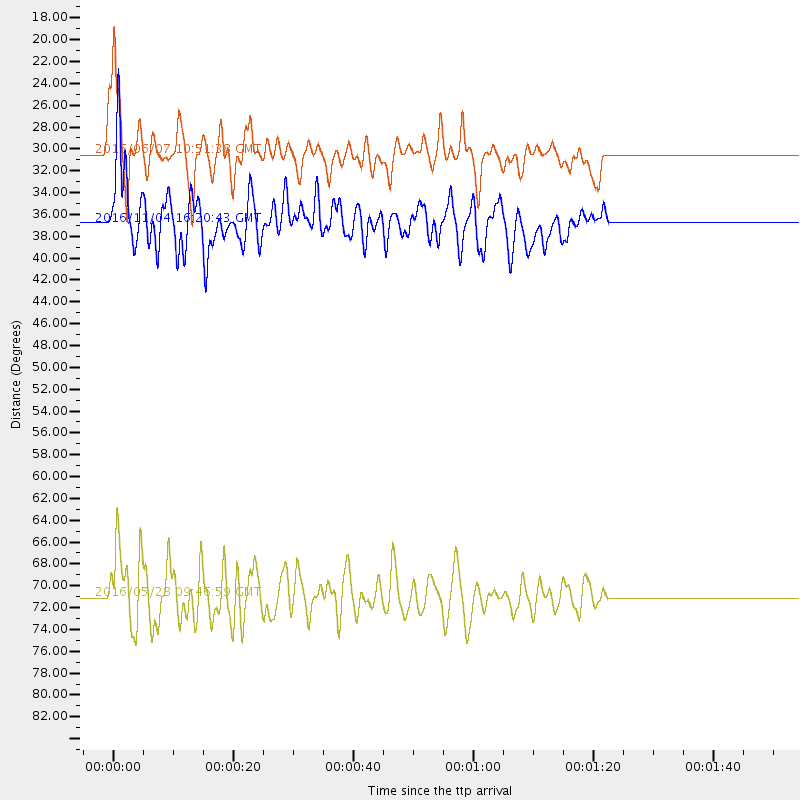
Events Used in the Stack
(3 events)| Radial Match | Distance | Baz | FERegion | Time | Lat/Lon | Depth | Magnitude |
| 89.1585 | 36.8 deg | 168.219 deg | Chile-Argentina Border Region | 2016/11/04 16:20:43 GMT | (-35.1, -71.0) | 91 km | 6.4 MWP, 6.4 MWW |
| 86.36858 | 71.1 deg | 151.975 deg | South Sandwich Islands Region | 2016/05/28 09:46:59 GMT | (-56.2, -26.9) | 73 km | 7.2 MWW, 7.3 MI |
| 81.711235 | 30.5 deg | 306.098 deg | Off Coast Of Jalisco, Mexico | 2016/06/07 10:51:38 GMT | (18.4, -105.2) | 10 km | 6.2 MWP |
Losers
(5 events)| Radial Match | Distance | Baz | FERegion | Time | Lat/Lon | Depth | Magnitude | Reason |
| 76.867676 | 34.0 deg | 163.394 deg | San Juan Province, Argentina | 2016/11/20 20:57:43 GMT | (-31.6, -68.8) | 116 km | 6.4 MWP, 6.5 MWB | |
| 70.16204 | 70.8 deg | 152.233 deg | South Sandwich Islands Region | 2016/07/31 11:33:20 GMT | (-56.3, -27.5) | 98 km | 5.9 MWW, 5.9 MWC, 5.9 MWB | |
| 59.87673 | 72.6 deg | 154.99 deg | South Sandwich Islands Region | 2016/09/22 16:07:27 GMT | (-59.5, -27.4) | 10 km | 5.6 MB | |
| 55.725605 | 31.9 deg | 159.616 deg | La Rioja Province, Argentina | 2016/11/13 14:01:01 GMT | (-28.9, -67.5) | 110 km | 6.2 MB, 5.7 MWR | |
| 44.06977 | 96.3 deg | 247.523 deg | South Of Fiji Islands | 2016/12/03 14:11:09 GMT | (-22.6, -176.0) | 153 km | 5.5 mb |

