
Station 8G EC03 - EC03
Network: 8G - 2016 Pedernales Earthquake Aftershock Deployment Ecuador
Nearby stations (2 deg radius)
| Station | Name | (Lat, Lon) | Start / End | Elevation |
| EC03 | EC03 | (0.66, -80.06) | 2016-05-01 / 2017-05-10 | 19 m |
| Crust2 Type: | A0,normal oceanic, 0.07 km seds. |
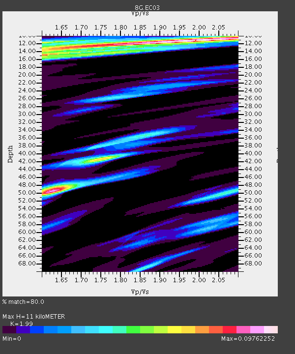
| Thickness Estimate: | 11 km |
| Thickness StdDev: | 18 km |
| Vp/Vs Estimate: | 1.99 |
| Vp/Vs StdDev: | 0.19 |
| Vs Estimate: | 2.131 km/s |
| Poisson's Ratio: | 0.33 |
| Peak Value: | 0.10 |
| Assumed Vp: | 4.24 km/s |
| Ps Weight: | 0.33333334 |
| PpPs Weight: | 0.33333334 |
| PsPs Weight: | 0.33333328 |
| Residual Complexity: | 0.711 |
| Nearby stations H: | +- |
| (2.0 deg) Vp/Vs: | +- |
1 with match > 90% ( 6.25 %) and 3 with match > 80% ( 18.75 %) out of 16.
Download stack as xyz text file.
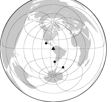
Azimuth Distribution of Events:
Prior Results for this Station
| Study | Thickness | Vp/Vs | Vp | Vs | Poissons Ratio | Extra |
| EARS | 11 km | 1.99 | 4.24 km/s | 2.131 km/s | 0.33 | |
| Crust2.0 | 12 km | 2.19 | 4.24 km/s | 1.94 km/s | 0.37 | A0,normal oceanic, 0.07 km seds. |
| Global Maxima | 11 km | 1.99 | 4.24 km/s | 2.131 km/s | 0.33 | amp=0.09762252 |
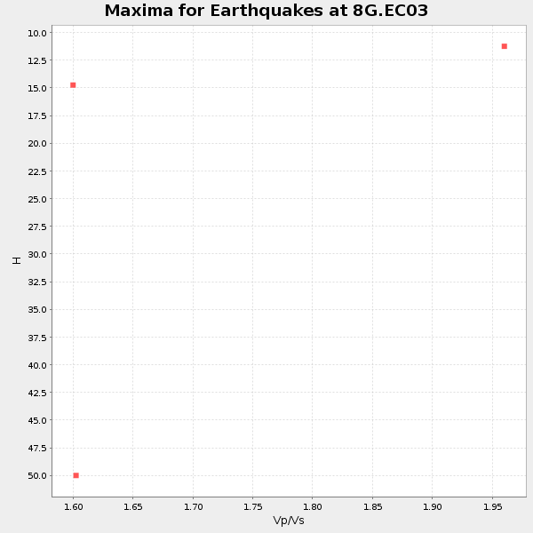
| Local Maxima 1 | 49 km | 1.63 | 4.24 km/s | 2.605 km/s | 0.20 | amp=0.086844526 |
| Local Maxima 2 | 15 km | 1.61 | 4.24 km/s | 2.633 km/s | 0.19 | amp=0.07652152 |
| Local Maxima 3 | 12 km | 1.60 | 4.24 km/s | 2.65 km/s | 0.18 | amp=0.060810175 |
| Local Maxima 4 | 41 km | 1.76 | 4.24 km/s | 2.406 km/s | 0.26 | amp=0.04778802 |
| Predicted Arrivals for vertical incidence (zero ray parameter) | |
| Ps | 2.57 SECOND |
| PpPs | 7.76 SECOND |
| PsPs/PpSs | 10.33 SECOND |
Events Processed for this Station
Download zip of receiver functions as SAC
Plot maxima for each earthquake.
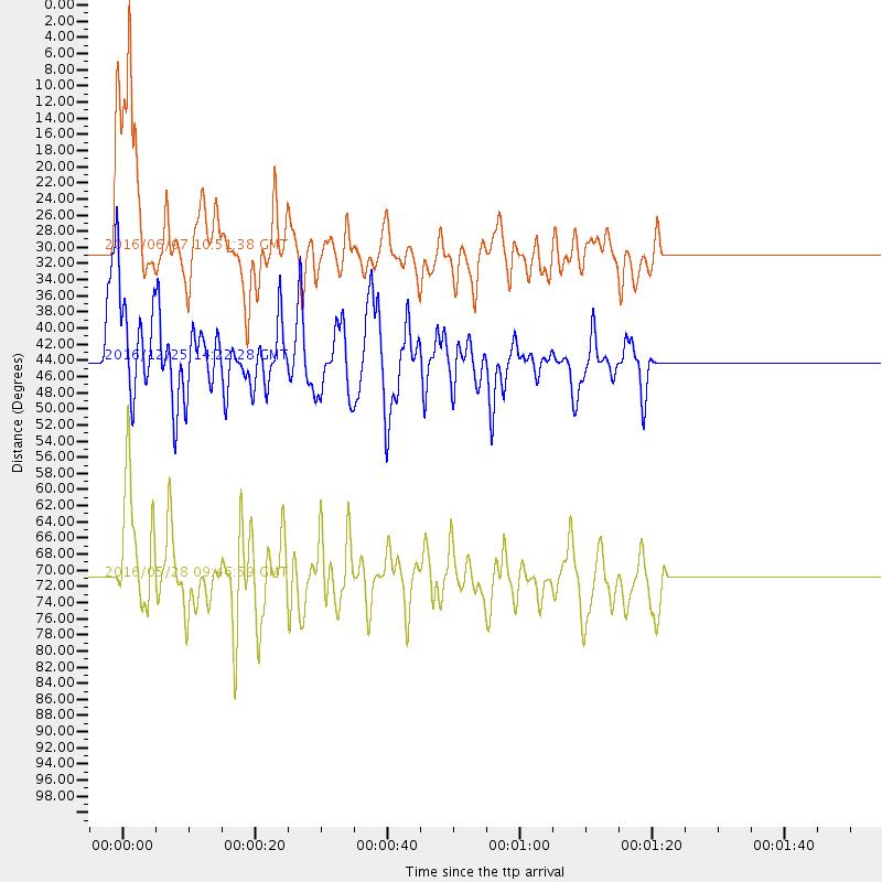
Events Used in the Stack
(3 events)| Radial Match | Distance | Baz | FERegion | Time | Lat/Lon | Depth | Magnitude |
| 91.04079 | 44.1 deg | 174.162 deg | Southern Chile | 2016/12/25 14:22:28 GMT | (-43.3, -74.5) | 15 km | 7.7 Mi |
| 86.11823 | 30.3 deg | 307.02 deg | Off Coast Of Jalisco, Mexico | 2016/06/07 10:51:38 GMT | (18.4, -105.2) | 10 km | 6.2 MWP |
| 81.41489 | 71.0 deg | 151.769 deg | South Sandwich Islands Region | 2016/05/28 09:46:59 GMT | (-56.2, -26.9) | 73 km | 7.2 MWW, 7.3 MI |
Losers
(13 events)| Radial Match | Distance | Baz | FERegion | Time | Lat/Lon | Depth | Magnitude | Reason |
| 79.24335 | 36.6 deg | 167.483 deg | Chile-Argentina Border Region | 2016/11/04 16:20:43 GMT | (-35.1, -71.0) | 91 km | 6.4 MWP, 6.4 MWW | |
| 77.16213 | 68.0 deg | 152.663 deg | South Georgia Island Region | 2016/08/19 17:33:40 GMT | (-55.2, -32.1) | 4.3 km | 5.8 MWW, 5.7 MWB, 5.8 MWC | |
| 76.63605 | 68.2 deg | 152.727 deg | South Georgia Island Region | 2016/08/19 07:32:22 GMT | (-55.3, -31.9) | 10 km | 7.4 MO | |
| 75.712845 | 33.9 deg | 162.557 deg | San Juan Province, Argentina | 2016/11/20 20:57:43 GMT | (-31.6, -68.8) | 116 km | 6.4 MWP, 6.5 MWB | |
| 63.798084 | 68.2 deg | 152.606 deg | South Georgia Island Region | 2016/08/21 03:45:23 GMT | (-55.3, -31.8) | 10 km | 6.4 MWP | |
| 63.754665 | 91.9 deg | 47.276 deg | Central Italy | 2016/10/30 06:40:19 GMT | (42.9, 13.1) | 10 km | 6.6 MWW, 6.6 MWR | |
| 56.397022 | 93.6 deg | 255.014 deg | Tonga Islands | 2016/07/23 20:09:19 GMT | (-15.1, -173.6) | 10 km | 5.7 MB | |
| 54.526196 | 72.6 deg | 154.803 deg | South Sandwich Islands Region | 2016/09/22 16:07:27 GMT | (-59.5, -27.4) | 10 km | 5.6 MB | |
| 53.33827 | 31.6 deg | 166.65 deg | Off Coast Of Central Chile | 2016/07/19 05:18:40 GMT | (-30.2, -72.0) | 14 km | 5.5 MB | |
| 49.41701 | 51.7 deg | 321.117 deg | California-Nevada Border Region | 2016/12/28 09:13:47 GMT | (38.4, -118.9) | 8.8 km | 5.5 ml | |
| 47.488758 | 66.8 deg | 98.351 deg | Ascension Island Region | 2016/06/10 09:26:53 GMT | (-7.5, -13.6) | 10 km | 5.5 MWP | |
| 27.249912 | 44.1 deg | 174.088 deg | Southern Chile | 2017/01/03 21:19:07 GMT | (-43.3, -74.4) | 11 km | 5.5 Mwr | |
| 21.031118 | 73.9 deg | 356.559 deg | Queen Elizabeth Islands, Canada | 2017/01/08 23:47:12 GMT | (74.3, -92.3) | 19 km | 5.8 Mwp |

