
Station 8G EC13 - EC13
Network: 8G - 2016 Pedernales Earthquake Aftershock Deployment Ecuador
Nearby stations (2 deg radius)
| Station | Name | (Lat, Lon) | Start / End | Elevation |
| EC13 | EC13 | (0.31, -79.95) | 2016-05-01 / 2017-05-10 | 37 m |
| Crust2 Type: | T6,Margin /shield transition, 1 km seds. |
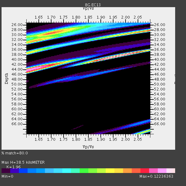
| Thickness Estimate: | 38 km |
| Thickness StdDev: | 17 km |
| Vp/Vs Estimate: | 1.96 |
| Vp/Vs StdDev: | 0.13 |
| Vs Estimate: | 3.302 km/s |
| Poisson's Ratio: | 0.32 |
| Peak Value: | 0.12 |
| Assumed Vp: | 6.472 km/s |
| Ps Weight: | 0.33333334 |
| PpPs Weight: | 0.33333334 |
| PsPs Weight: | 0.33333328 |
| Residual Complexity: | 0.851 |
| Nearby stations H: | +- |
| (2.0 deg) Vp/Vs: | +- |
2 with match > 90% ( 11.111111 %) and 3 with match > 80% ( 16.666666 %) out of 18.
Download stack as xyz text file.
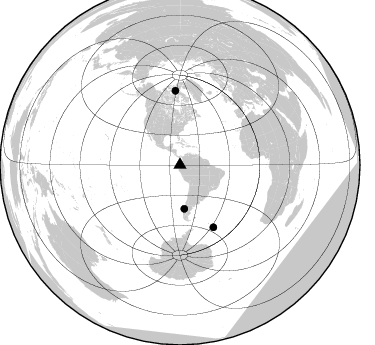
Azimuth Distribution of Events:
Prior Results for this Station
| Study | Thickness | Vp/Vs | Vp | Vs | Poissons Ratio | Extra |
| EARS | 38 km | 1.96 | 6.472 km/s | 3.302 km/s | 0.32 | |
| Crust2.0 | 32 km | 1.79 | 6.472 km/s | 3.622 km/s | 0.27 | T6,Margin /shield transition, 1 km seds. |
| Global Maxima | 38 km | 1.96 | 6.472 km/s | 3.302 km/s | 0.32 | amp=0.12236363 |
| Local Maxima 1 | 28 km | 2.10 | 6.472 km/s | 3.086 km/s | 0.35 | amp=0.1001479 |
| Local Maxima 2 | 45 km | 1.60 | 6.472 km/s | 4.045 km/s | 0.18 | amp=0.09476293 |
| Local Maxima 3 | 29 km | 1.69 | 6.472 km/s | 3.824 km/s | 0.23 | amp=0.094671935 |
| Local Maxima 4 | 37 km | 1.60 | 6.472 km/s | 4.045 km/s | 0.18 | amp=0.08017209 |
| Predicted Arrivals for vertical incidence (zero ray parameter) | |
| Ps | 5.71 SECOND |
| PpPs | 17.61 SECOND |
| PsPs/PpSs | 23.32 SECOND |
Events Processed for this Station
Download zip of receiver functions as SAC
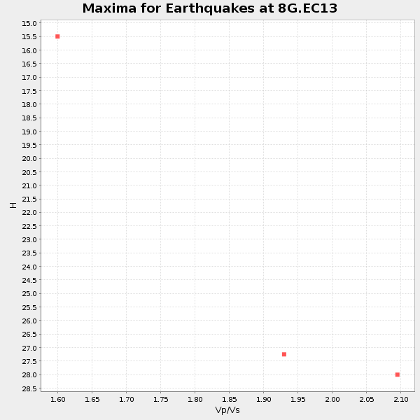
Plot maxima for each earthquake.
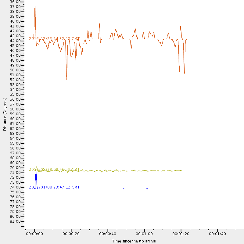
Events Used in the Stack
(3 events)| Radial Match | Distance | Baz | FERegion | Time | Lat/Lon | Depth | Magnitude |
| 99.83513 | 74.3 deg | 356.534 deg | Queen Elizabeth Islands, Canada | 2017/01/08 23:47:12 GMT | (74.3, -92.3) | 19 km | 5.8 Mwp |
| 92.63671 | 70.6 deg | 151.746 deg | South Sandwich Islands Region | 2016/05/28 09:46:59 GMT | (-56.2, -26.9) | 73 km | 7.2 MWW, 7.3 MI |
| 89.353806 | 43.9 deg | 174.283 deg | Southern Chile | 2016/12/25 14:32:13 GMT | (-43.5, -74.5) | 17 km | 5.6 mb |
Losers
(15 events)| Radial Match | Distance | Baz | FERegion | Time | Lat/Lon | Depth | Magnitude | Reason |
| 99.73711 | 94.8 deg | 254.683 deg | Tonga Islands | 2016/10/25 16:10:01 GMT | (-15.4, -174.8) | 0.0 km | 5.8 | |
| 88.490265 | 43.7 deg | 174.24 deg | Southern Chile | 2016/12/25 14:22:28 GMT | (-43.3, -74.5) | 15 km | 7.7 Mi | |
| 80.48974 | 67.8 deg | 152.702 deg | South Georgia Island Region | 2016/08/19 07:32:22 GMT | (-55.3, -31.9) | 10 km | 7.4 MO | |
| 79.55981 | 57.9 deg | 319.459 deg | Off Coast Of Northern California | 2016/12/08 14:49:46 GMT | (40.5, -126.2) | 12 km | 6.5 Mwb | |
| 77.10002 | 32.6 deg | 167.203 deg | Near Coast Of Central Chile | 2016/12/08 20:42:37 GMT | (-31.6, -71.9) | 30 km | 5.2 Mwr | |
| 71.102005 | 67.8 deg | 152.581 deg | South Georgia Island Region | 2016/08/21 03:45:23 GMT | (-55.3, -31.8) | 10 km | 6.4 MWP | |
| 68.99361 | 30.6 deg | 307.385 deg | Off Coast Of Jalisco, Mexico | 2016/06/07 10:51:38 GMT | (18.4, -105.2) | 10 km | 6.2 MWP | |
| 66.61794 | 96.3 deg | 255.061 deg | Fiji Islands Region | 2017/02/20 23:55:48 GMT | (-15.0, -176.4) | 6.0 km | 5.5 Mww | |
| 61.89639 | 37.1 deg | 68.159 deg | Northern Mid-Atlantic Ridge | 2016/10/20 00:09:26 GMT | (13.3, -44.9) | 10 km | 5.7 MWP | |
| 61.70779 | 31.2 deg | 251.76 deg | Central East Pacific Rise | 2016/12/11 14:33:12 GMT | (-9.1, -109.8) | 10 km | 5.7 Mwb | |
| 60.583454 | 97.1 deg | 239.733 deg | Kermadec Islands, New Zealand | 2016/06/01 15:37:23 GMT | (-30.2, -178.0) | 44 km | 5.5 MWC, 5.5 MWC | |
| 59.869442 | 72.2 deg | 154.787 deg | South Sandwich Islands Region | 2016/09/22 16:07:27 GMT | (-59.5, -27.4) | 10 km | 5.6 MB | |
| 55.41178 | 72.6 deg | 153.622 deg | South Sandwich Islands Region | 2016/08/02 07:32:29 GMT | (-58.7, -25.6) | 35 km | 5.5 MWW, 5.4 MWB, 5.6 MWC | |
| 53.194706 | 31.3 deg | 166.694 deg | Off Coast Of Central Chile | 2016/07/19 05:18:40 GMT | (-30.2, -72.0) | 14 km | 5.5 MB | |
| 52.624706 | 54.2 deg | 45.269 deg | Northern Mid-Atlantic Ridge | 2016/07/15 18:02:49 GMT | (35.2, -35.2) | 16 km | 5.5 mwb |

