
Station 8G EC19 - EC19
Network: 8G - 2016 Pedernales Earthquake Aftershock Deployment Ecuador
Nearby stations (2 deg radius)
| Station | Name | (Lat, Lon) | Start / End | Elevation |
| EC19 | EC19 | (-1.07, -80.67) | 2016-05-01 / 2017-05-10 | 204 m |
| Crust2 Type: | S1,continental slope, margin, transition 1 km seds. |
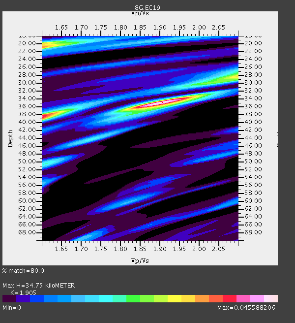
| Thickness Estimate: | 35 km |
| Thickness StdDev: | 6.8 km |
| Vp/Vs Estimate: | 1.90 |
| Vp/Vs StdDev: | 0.19 |
| Vs Estimate: | 3.245 km/s |
| Poisson's Ratio: | 0.31 |
| Peak Value: | 0.05 |
| Assumed Vp: | 6.183 km/s |
| Ps Weight: | 0.33333334 |
| PpPs Weight: | 0.33333334 |
| PsPs Weight: | 0.33333328 |
| Residual Complexity: | 0.690 |
| Nearby stations H: | +- |
| (2.0 deg) Vp/Vs: | +- |
1 with match > 90% ( 4.5454545 %) and 4 with match > 80% ( 18.181818 %) out of 22.
Download stack as xyz text file.
Azimuth Distribution of Events:

Prior Results for this Station
| Study | Thickness | Vp/Vs | Vp | Vs | Poissons Ratio | Extra |
| EARS | 35 km | 1.90 | 6.183 km/s | 3.245 km/s | 0.31 | |
| Crust2.0 | 23 km | 1.81 | 6.183 km/s | 3.422 km/s | 0.28 | S1,continental slope, margin, transition 1 km seds. |
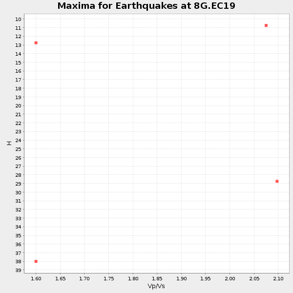
| Global Maxima | 35 km | 1.90 | 6.183 km/s | 3.245 km/s | 0.31 | amp=0.045588206 |
| Local Maxima 1 | 21 km | 1.60 | 6.183 km/s | 3.864 km/s | 0.18 | amp=0.03357596 |
| Local Maxima 2 | 38 km | 1.60 | 6.183 km/s | 3.864 km/s | 0.18 | amp=0.032281566 |
| Local Maxima 3 | 20 km | 1.60 | 6.183 km/s | 3.864 km/s | 0.18 | amp=0.021943597 |
| Local Maxima 4 | 28 km | 2.10 | 6.183 km/s | 2.948 km/s | 0.35 | amp=0.02126392 |
| Predicted Arrivals for vertical incidence (zero ray parameter) | |
| Ps | 5.09 SECOND |
| PpPs | 16.33 SECOND |
| PsPs/PpSs | 21.41 SECOND |
Events Processed for this Station
Download zip of receiver functions as SAC
Plot maxima for each earthquake.
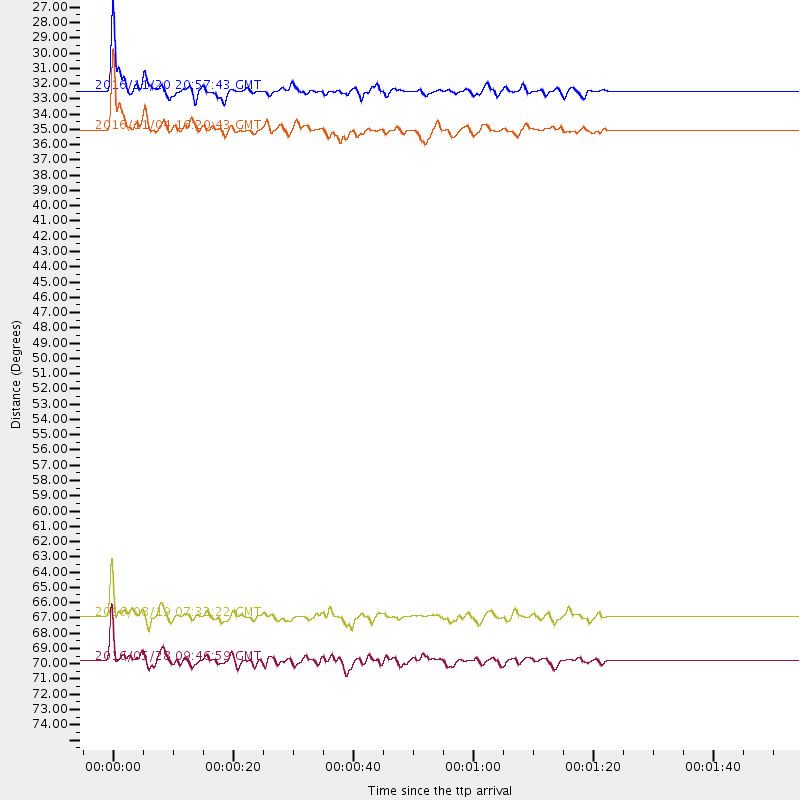
Events Used in the Stack
(4 events)| Radial Match | Distance | Baz | FERegion | Time | Lat/Lon | Depth | Magnitude |
| 91.29577 | 32.4 deg | 160.847 deg | San Juan Province, Argentina | 2016/11/20 20:57:43 GMT | (-31.6, -68.8) | 116 km | 6.4 MWP, 6.5 MWB |
| 88.69782 | 69.8 deg | 151.288 deg | South Sandwich Islands Region | 2016/05/28 09:46:59 GMT | (-56.2, -26.9) | 73 km | 7.2 MWW, 7.3 MI |
| 84.738655 | 66.9 deg | 152.177 deg | South Georgia Island Region | 2016/08/19 07:32:22 GMT | (-55.3, -31.9) | 10 km | 7.4 MO |
| 82.16091 | 35.0 deg | 166.118 deg | Chile-Argentina Border Region | 2016/11/04 16:20:43 GMT | (-35.1, -71.0) | 91 km | 6.4 MWP, 6.4 MWW |
Losers
(18 events)| Radial Match | Distance | Baz | FERegion | Time | Lat/Lon | Depth | Magnitude | Reason |
| 95.22893 | 97.6 deg | 232.573 deg | Off E. Coast Of N. Island, N.Z. | 2016/09/01 17:14:05 GMT | (-37.0, 179.0) | 14 km | 5.7 MB | |
| 83.27842 | 41.9 deg | 53.521 deg | Northern Mid-Atlantic Ridge | 2016/06/21 16:26:34 GMT | (22.7, -45.1) | 10 km | 6.1 MWB | |
| 77.44942 | 62.8 deg | 89.508 deg | North Of Ascension Island | 2016/08/29 04:29:57 GMT | (-0.0, -17.8) | 10 km | 7.1 MWW, 7.1 MWC, 7.4 MI | |
| 77.06902 | 67.0 deg | 152.056 deg | South Georgia Island Region | 2016/08/21 03:45:23 GMT | (-55.3, -31.8) | 10 km | 6.4 MWP | |
| 73.510506 | 92.4 deg | 250.465 deg | Tonga Islands | 2016/09/02 11:23:07 GMT | (-19.6, -173.6) | 10 km | 5.5 MB | |
| 69.34626 | 30.9 deg | 309.939 deg | Off Coast Of Jalisco, Mexico | 2016/06/07 10:51:38 GMT | (18.4, -105.2) | 10 km | 6.2 MWP | |
| 68.33651 | 97.5 deg | 232.221 deg | Off E. Coast Of N. Island, N.Z. | 2016/09/01 16:37:57 GMT | (-37.4, 179.1) | 19 km | 7.1 MWW, 7.0 MWW, 7.2 MI | |
| 68.05246 | 97.4 deg | 321.276 deg | Rat Islands, Aleutian Islands | 2016/11/14 02:12:17 GMT | (51.1, 178.8) | 34 km | 5.6 MWW, 5.0 ML, 5.4 ML | |
| 60.324112 | 96.9 deg | 232.289 deg | Off E. Coast Of N. Island, N.Z. | 2016/09/01 16:47:12 GMT | (-37.4, 179.8) | 10 km | 5.6 MB | |
| 52.134727 | 34.5 deg | 168.146 deg | Near Coast Of Central Chile | 2016/08/30 08:09:10 GMT | (-34.9, -72.5) | 19 km | 5.5 MB, 5.5 MB | |
| 50.760567 | 97.5 deg | 231.991 deg | Off E. Coast Of N. Island, N.Z. | 2016/09/01 20:06:08 GMT | (-37.6, 179.1) | 14 km | 5.5 MB | |
| 50.74818 | 67.1 deg | 97.593 deg | Ascension Island Region | 2016/06/10 09:26:53 GMT | (-7.5, -13.6) | 10 km | 5.5 MWP | |
| 46.834282 | 30.1 deg | 164.958 deg | Off Coast Of Central Chile | 2016/07/19 05:18:40 GMT | (-30.2, -72.0) | 14 km | 5.5 MB | |
| 41.506706 | 97.5 deg | 232.389 deg | Off E. Coast Of N. Island, N.Z. | 2016/09/01 16:48:02 GMT | (-37.2, 179.1) | 14 km | 5.6 MB | |
| 41.017166 | 94.5 deg | 247.384 deg | South Of Fiji Islands | 2016/12/03 14:11:09 GMT | (-22.6, -176.0) | 153 km | 5.5 mb | |
| 40.697422 | 93.5 deg | 47.318 deg | Central Italy | 2016/10/30 06:40:19 GMT | (42.9, 13.1) | 10 km | 6.6 MWW, 6.6 MWR | |
| 28.630522 | 94.5 deg | 241.789 deg | Kermadec Islands Region | 2016/07/15 10:16:54 GMT | (-28.2, -176.4) | 10 km | 5.6 mwb | |
| 22.094255 | 92.2 deg | 254.966 deg | Tonga Islands | 2016/07/10 13:44:41 GMT | (-15.1, -173.2) | 10 km | 5.5 MB, 5.8 MWB |

