
Station 9G BB01 - Peanut Lake BB01
Network: 9G - Impact of Supraglacial Lakes on Ice-Shelf Stability
Nearby stations (2 deg radius)
| Station | Name | (Lat, Lon) | Start / End | Elevation |
| BB01 | Peanut Lake BB01 | (-77.89, 166.00) | 2016-11-22 / 2017-01-20 | 3.0 m |
| Crust2 Type: | S1,continental slope, margin, transition 1 km seds. |
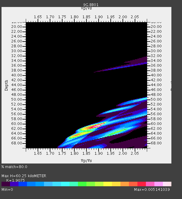
| Thickness Estimate: | 60 km |
| Thickness StdDev: | 11 km |
| Vp/Vs Estimate: | 1.91 |
| Vp/Vs StdDev: | 0.07 |
| Vs Estimate: | 3.241 km/s |
| Poisson's Ratio: | 0.31 |
| Peak Value: | 0.01 |
| Assumed Vp: | 6.183 km/s |
| Ps Weight: | 0.33333334 |
| PpPs Weight: | 0.33333334 |
| PsPs Weight: | 0.33333328 |
| Residual Complexity: | 0.629 |
| Nearby stations H: | +- |
| (2.0 deg) Vp/Vs: | +- |
1 with match > 90% ( 6.25 %) and 3 with match > 80% ( 18.75 %) out of 16.
Download stack as xyz text file.
Azimuth Distribution of Events:

Prior Results for this Station
| Study | Thickness | Vp/Vs | Vp | Vs | Poissons Ratio | Extra |
| EARS | 60 km | 1.91 | 6.183 km/s | 3.241 km/s | 0.31 | |
| Crust2.0 | 23 km | 1.81 | 6.183 km/s | 3.422 km/s | 0.28 | S1,continental slope, margin, transition 1 km seds. |
| Global Maxima | 60 km | 1.91 | 6.183 km/s | 3.241 km/s | 0.31 | amp=0.005141039 |
| Local Maxima 1 | 64 km | 1.81 | 6.183 km/s | 3.425 km/s | 0.28 | amp=0.0037174176 |
| Local Maxima 2 | 63 km | 1.99 | 6.183 km/s | 3.115 km/s | 0.33 | amp=0.0029119377 |
| Local Maxima 3 | 65 km | 1.92 | 6.183 km/s | 3.216 km/s | 0.31 | amp=0.0014940901 |
| Local Maxima 4 | 54 km | 1.96 | 6.183 km/s | 3.15 km/s | 0.32 | amp=0.0011455021 |
| Predicted Arrivals for vertical incidence (zero ray parameter) | |
| Ps | 8.84 SECOND |
| PpPs | 28.33 SECOND |
| PsPs/PpSs | 37.18 SECOND |
Events Processed for this Station
Download zip of receiver functions as SAC
Plot maxima for each earthquake.
Events Used in the Stack
(3 events)| Radial Match | Distance | Baz | FERegion | Time | Lat/Lon | Depth | Magnitude |
| 93.11785 | 72.4 deg | 347.973 deg | Solomon Islands | 2016/12/10 16:24:36 GMT | (-5.7, 154.5) | 157 km | 6.1 Mwp |
| 82.63711 | 67.0 deg | 355.103 deg | Solomon Islands | 2016/12/09 21:38:23 GMT | (-10.9, 161.4) | 10 km | 5.8 Mww |
| 82.13288 | 67.7 deg | 354.909 deg | Solomon Islands | 2016/12/20 04:21:28 GMT | (-10.2, 161.2) | 11 km | 6.4 mww |
Losers
(13 events)| Radial Match | Distance | Baz | FERegion | Time | Lat/Lon | Depth | Magnitude | Reason |
| 94.56676 | 91.0 deg | 290.728 deg | Northern Sumatra, Indonesia | 2016/12/06 22:03:32 GMT | (5.3, 96.1) | 8.2 km | 6.5 Mww | |
| 93.98329 | 91.4 deg | 289.295 deg | Northern Sumatra, Indonesia | 2017/01/17 11:48:48 GMT | (5.4, 94.6) | 55 km | 5.6 mb | |
| 92.324036 | 67.7 deg | 354.671 deg | Solomon Islands | 2016/12/20 08:49:25 GMT | (-10.2, 161.0) | 38 km | 5.5 mb | |
| 92.213844 | 56.0 deg | 20.112 deg | South Of Fiji Islands | 2016/12/03 14:11:09 GMT | (-22.6, -176.0) | 153 km | 5.5 mb | |
| 91.73185 | 53.5 deg | 128.007 deg | Southern Chile | 2016/12/25 14:32:13 GMT | (-43.5, -74.5) | 17 km | 5.6 mb | |
| 91.63137 | 67.1 deg | 354.988 deg | Solomon Islands | 2016/12/08 21:56:07 GMT | (-10.8, 161.3) | 15 km | 6.5 Mww | |
| 89.369156 | 72.4 deg | 347.393 deg | New Ireland Region, P.N.G. | 2016/12/17 11:27:41 GMT | (-5.7, 153.9) | 40 km | 6.0 mb | |
| 86.74933 | 67.0 deg | 355.013 deg | Solomon Islands | 2016/12/09 19:43:23 GMT | (-11.0, 161.3) | 18 km | 5.5 mb | |
| 84.54317 | 83.9 deg | 322.043 deg | North Of Halmahera, Indonesia | 2017/01/01 14:13:37 GMT | (3.6, 128.2) | 35 km | 5.5 mb | |
| 83.688126 | 73.7 deg | 347.082 deg | New Ireland Region, P.N.G. | 2016/12/17 10:51:11 GMT | (-4.5, 153.6) | 73 km | 8.0 Mi | |
| 78.26641 | 65.6 deg | 127.416 deg | Near Coast Of Central Chile | 2016/12/08 20:42:37 GMT | (-31.6, -71.9) | 30 km | 5.2 Mwr | |
| 77.89375 | 79.9 deg | 86.21 deg | Central East Pacific Rise | 2016/12/11 14:33:12 GMT | (-9.1, -109.8) | 10 km | 5.7 Mwb | |
| 57.129784 | 59.9 deg | 238.846 deg | Southwest Indian Ridge | 2017/01/02 00:13:06 GMT | (-36.0, 51.9) | 10 km | 5.7 Mwb |

