
Station AF CRLN - Carolina, Mapumpalanga, South Africa
Network: AF - Africa Array
Nearby stations (2 deg radius)
| Station | Name | (Lat, Lon) | Start / End | Elevation |
| CRLN | Carolina, Mapumpalanga, South Africa | (-25.99, 30.02) | 2015-05-14 / 2599-12-31 | 1600 m |
| Crust2 Type: | IE,late Proter., no seds. |
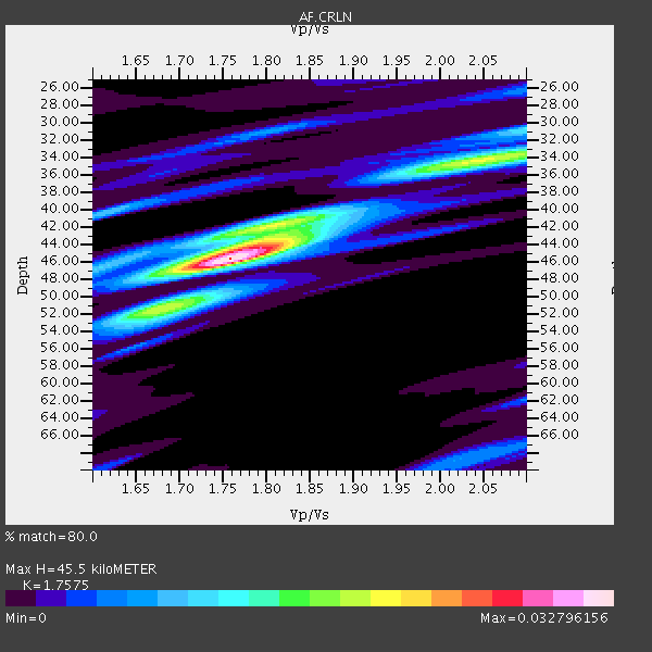
| Thickness Estimate: | 46 km |
| Thickness StdDev: | 6.4 km |
| Vp/Vs Estimate: | 1.76 |
| Vp/Vs StdDev: | 0.14 |
| Vs Estimate: | 3.784 km/s |
| Poisson's Ratio: | 0.26 |
| Peak Value: | 0.03 |
| Assumed Vp: | 6.65 km/s |
| Ps Weight: | 0.33333334 |
| PpPs Weight: | 0.33333334 |
| PsPs Weight: | 0.33333328 |
| Residual Complexity: | 0.596 |
| Nearby stations H: | +- |
| (2.0 deg) Vp/Vs: | +- |
2 with match > 90% ( 11.764706 %) and 4 with match > 80% ( 23.529411 %) out of 17.
Download stack as xyz text file.
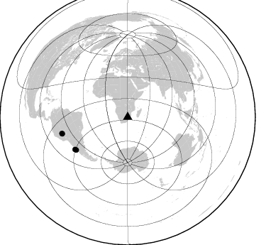
Azimuth Distribution of Events:
Prior Results for this Station
| Study | Thickness | Vp/Vs | Vp | Vs | Poissons Ratio | Extra |
| EARS | 46 km | 1.76 | 6.65 km/s | 3.784 km/s | 0.26 | |
| Crust2.0 | 36 km | 1.77 | 6.65 km/s | 3.758 km/s | 0.27 | IE,late Proter., no seds. |
| Global Maxima | 46 km | 1.76 | 6.65 km/s | 3.784 km/s | 0.26 | amp=0.032796156 |
| Local Maxima 1 | 34 km | 2.04 | 6.65 km/s | 3.256 km/s | 0.34 | amp=0.019148761 |
| Local Maxima 2 | 42 km | 1.80 | 6.65 km/s | 3.689 km/s | 0.28 | amp=0.014069542 |
| Local Maxima 3 | 51 km | 1.69 | 6.65 km/s | 3.935 km/s | 0.23 | amp=0.011507571 |
| Local Maxima 4 | 30 km | 2.10 | 6.65 km/s | 3.17 km/s | 0.35 | amp=0.008268893 |
| Predicted Arrivals for vertical incidence (zero ray parameter) | |
| Ps | 5.18 SECOND |
| PpPs | 18.87 SECOND |
| PsPs/PpSs | 24.05 SECOND |
Events Processed for this Station
Download zip of receiver functions as SAC
Plot maxima for each earthquake.
Events Used in the Stack
(4 events)| Radial Match | Distance | Baz | FERegion | Time | Lat/Lon | Depth | Magnitude |
| 94.02357 | 95.1 deg | 255.705 deg | Peru-Brazil Border Region | 2015/11/24 22:45:38 GMT | (-10.6, -71.0) | 602 km | 7.5 MWW, 6.9 MI |
| 93.894844 | 87.2 deg | 238.628 deg | Off Coast Of Central Chile | 2015/11/11 01:54:37 GMT | (-29.4, -72.1) | 10 km | 6.9 MWW, 6.6 MI |
| 89.93093 | 95.4 deg | 256.08 deg | Peru-Brazil Border Region | 2015/11/24 22:50:53 GMT | (-10.1, -71.1) | 595 km | 5.9 MB |
| 84.72742 | 86.1 deg | 237.565 deg | Near Coast Of Central Chile | 2015/11/07 07:31:42 GMT | (-30.9, -71.5) | 36 km | 6.8 MWP, 6.8 MI |
Losers
(13 events)| Radial Match | Distance | Baz | FERegion | Time | Lat/Lon | Depth | Magnitude | Reason |
| 97.291824 | 73.0 deg | 33.354 deg | Hindu Kush Region, Afghanistan | 2015/10/26 09:09:32 GMT | (36.4, 70.7) | 212 km | 7.5 MWW, 7.5 MWB | |
| 92.82328 | 48.0 deg | 131.837 deg | Southeast Indian Ridge | 2015/12/04 22:24:54 GMT | (-47.7, 85.2) | 10 km | 7.1 MWP | |
| 90.56323 | 73.3 deg | 33.584 deg | Afghanistan-Tajikistan Bord Reg. | 2015/12/25 19:14:48 GMT | (36.5, 71.1) | 204 km | 6.2 MO | |
| 76.89677 | 96.7 deg | 97.848 deg | Banda Sea | 2015/12/09 10:21:50 GMT | (-4.1, 129.5) | 34 km | 6.9 MWP | |
| 67.51757 | 96.0 deg | 256.766 deg | Peru-Brazil Border Region | 2015/11/26 05:45:18 GMT | (-9.2, -71.3) | 604 km | 6.4 MWP | |
| 67.30132 | 86.1 deg | 237.867 deg | Near Coast Of Central Chile | 2015/12/19 19:25:04 GMT | (-30.6, -71.4) | 46 km | 5.8 MWR | |
| 62.953747 | 81.1 deg | 241.214 deg | Santiago Del Estero Prov., Arg. | 2015/11/13 06:04:15 GMT | (-29.9, -64.5) | 11 km | 5.8 MWP | |
| 57.24192 | 90.7 deg | 99.588 deg | Timor Region | 2015/11/04 03:44:15 GMT | (-8.4, 124.9) | 14 km | 6.3 MWP | |
| 55.724884 | 73.4 deg | 33.818 deg | Afghanistan-Tajikistan Bord Reg. | 2015/11/22 18:16:04 GMT | (36.5, 71.5) | 92 km | 5.9 MB | |
| 54.159027 | 86.0 deg | 237.8 deg | Near Coast Of Central Chile | 2015/11/07 10:53:38 GMT | (-30.7, -71.3) | 3.8 km | 5.9 MB | |
| 52.213333 | 70.6 deg | 72.483 deg | Nicobar Islands, India Region | 2015/11/09 08:12:49 GMT | (6.4, 94.8) | 35 km | 5.5 MB | |
| 51.297127 | 71.4 deg | 79.738 deg | Northern Sumatra, Indonesia | 2015/11/08 09:34:57 GMT | (0.7, 98.9) | 75 km | 6.1 MB | |
| 46.258263 | 86.3 deg | 237.59 deg | Near Coast Of Central Chile | 2015/12/08 12:56:07 GMT | (-30.8, -71.7) | 30 km | 5.6 MB |

