
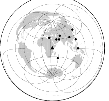
Station AF NBI - Nairobi, Kenya, Africa
Network: AF - Africa Array
Nearby stations (2 deg radius)

| Station | Name | (Lat, Lon) | Start / End | Elevation |
| NBI | Nairobi, Kenya, Africa | (-1.27, 36.80) | 2011-03-08 / 2599-12-31 | 1713 m |
| Crust2 Type: | X5,thick Rift 0.25 km sediments |
| Thickness Estimate: | 44 km |
| Thickness StdDev: | 3.9 km |
| Vp/Vs Estimate: | 1.80 |
| Vp/Vs StdDev: | 0.07 |
| Vs Estimate: | 3.662 km/s |
| Poisson's Ratio: | 0.28 |
| Peak Value: | 0.03 |
| Assumed Vp: | 6.601 km/s |
| Ps Weight: | 0.33333334 |
| PpPs Weight: | 0.33333334 |
| PsPs Weight: | 0.33333328 |
| Residual Complexity: | 0.547 |
| Nearby stations H: | 48 km +- 9.5 km |
| (2.0 deg) Vp/Vs: | 1.75 +- 0.11 |
6 with match > 90% ( 50.0 %) and 10 with match > 80% ( 83.333336 %) out of 12.
Download stack as xyz text file.
Azimuth Distribution of Events:
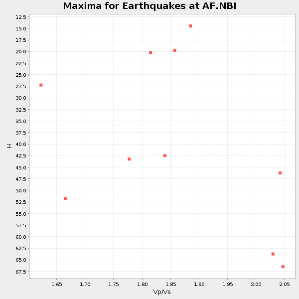
Prior Results for this Station
| Study | Thickness | Vp/Vs | Vp | Vs | Poissons Ratio | Extra |
| EARS | 44 km | 1.80 | 6.601 km/s | 3.662 km/s | 0.28 | |
| Crust2.0 | 38 km | 1.77 | 6.601 km/s | 3.729 km/s | 0.27 | X5,thick Rift 0.25 km sediments |
| Global Maxima | 44 km | 1.80 | 6.601 km/s | 3.662 km/s | 0.28 | amp=0.031285215 |
| Local Maxima 1 | 51 km | 1.72 | 6.601 km/s | 3.843 km/s | 0.24 | amp=0.013496319 |
| Local Maxima 2 | 51 km | 1.93 | 6.601 km/s | 3.411 km/s | 0.32 | amp=0.013157494 |
| Local Maxima 3 | 32 km | 1.60 | 6.601 km/s | 4.125 km/s | 0.18 | amp=0.011415893 |
| Local Maxima 4 | 28 km | 1.60 | 6.601 km/s | 4.119 km/s | 0.18 | amp=0.011006471 |
| Predicted Arrivals for vertical incidence (zero ray parameter) | |
| Ps | 5.29 SECOND |
| PpPs | 18.47 SECOND |
| PsPs/PpSs | 23.76 SECOND |
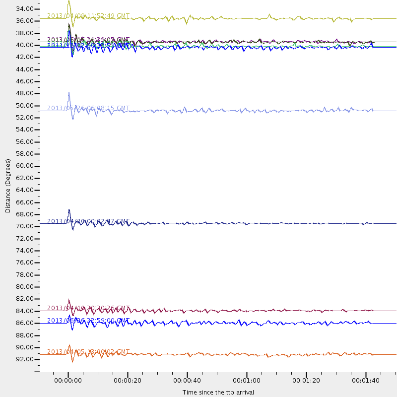
Events Processed for this Station
Download zip of receiver functions as SAC
Plot maxima for each earthquake.
Events Used in the Stack
(10 events)| Radial Match | Distance | Baz | FERegion | Time | Lat/Lon | Depth | Magnitude |
| 97.42074 | 70.2 deg | 57.186 deg | Sichuan, China | 2013/04/20 00:02:47 GMT | (30.3, 102.9) | 14 km | 6.6 MW, 6.5 MB, 6.6 MW, 6.8 MS |
| 95.44973 | 37.9 deg | 37.801 deg | Southern Iran | 2013/04/16 10:44:20 GMT | (28.0, 62.0) | 80 km | 7.7 MW, 7.0 MB, 7.7 MW |
| 94.56171 | 37.1 deg | 343.921 deg | Crete, Greece | 2013/06/16 21:39:05 GMT | (34.3, 25.2) | 19 km | 6.0 MW, 5.7 MS, 5.8 MW, 5.9 MB |
| 93.661316 | 86.0 deg | 69.253 deg | Philippine Islands Region | 2013/04/10 20:20:26 GMT | (20.7, 122.1) | 12 km | 5.8 MW, 5.7 MS, 5.9 MW, 6.0 MB |
| 92.95707 | 49.6 deg | 30.819 deg | Southeastern Uzbekistan | 2013/05/26 06:08:15 GMT | (40.0, 67.3) | 18 km | 5.7 MW, 5.6 MW, 5.9 MS, 6.2 MB |
| 91.10906 | 37.2 deg | 343.771 deg | Crete, Greece | 2013/06/15 16:11:02 GMT | (34.4, 25.0) | 10 km | 6.2 MW, 6.0 MB, 6.0 MS, 6.1 MW |
| 88.76378 | 93.9 deg | 47.436 deg | E. Russia-N.E. China Border Reg. | 2013/04/05 13:00:02 GMT | (42.7, 131.0) | 563 km | 6.3 MW, 6.2 MB, 6.4 MW |
| 88.72464 | 32.8 deg | 24.546 deg | Southern Iran | 2013/04/09 11:52:49 GMT | (28.4, 51.6) | 12 km | 6.4 MW, 5.9 MB, 6.2 MW, 6.3 MS |
| 85.000534 | 38.2 deg | 150.802 deg | South Indian Ocean | 2011/12/02 00:22:51 GMT | (-34.0, 58.1) | 10 km | 5.7 MB, 5.1 MS, 5.6 MW, 5.4 MW |
| 81.094536 | 88.2 deg | 90.101 deg | Southern Molucca Sea | 2013/06/26 22:59:00 GMT | (-0.1, 125.1) | 33 km | 5.5 MW, 5.9 MB |
Losers
(2 events)| Radial Match | Distance | Baz | FERegion | Time | Lat/Lon | Depth | Magnitude | Reason |
| 74.27721 | 38.2 deg | 38.079 deg | Southwestern Pakistan | 2013/04/17 03:15:52 GMT | (28.1, 62.4) | 56 km | 5.6 MW, 5.6 MW, 5.7 MB | |
| 73.500626 | 93.3 deg | 96.334 deg | Banda Sea | 2013/04/20 04:51:12 GMT | (-6.3, 130.2) | 108 km | 6.0 MW, 5.9 MW, 6.0 MB |
