
Station AF SVMA - Madeiral, Sao Vicente, Cape Verde
Network: AF - Africa Array
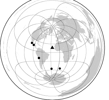
Nearby stations (2 deg radius)
| Station | Name | (Lat, Lon) | Start / End | Elevation |
| SVMA | Madeiral, Sao Vicente, Cape Verde | (16.84, -24.92) | 2013-01-01 / 2599-12-31 | 195 m |
| Crust2 Type: | B1,melt affected o.c. and oceanic plateaus, 0.5 km seds. |
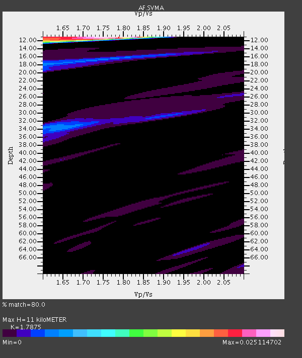
| Thickness Estimate: | 11 km |
| Thickness StdDev: | 7.1 km |
| Vp/Vs Estimate: | 1.79 |
| Vp/Vs StdDev: | 0.08 |
| Vs Estimate: | 2.646 km/s |
| Poisson's Ratio: | 0.27 |
| Peak Value: | 0.03 |
| Assumed Vp: | 4.73 km/s |
| Ps Weight: | 0.33333334 |
| PpPs Weight: | 0.33333334 |
| PsPs Weight: | 0.33333328 |
| Residual Complexity: | 0.398 |
| Nearby stations H: | +- |
| (2.0 deg) Vp/Vs: | +- |
2 with match > 90% ( 5.714286 %) and 7 with match > 80% ( 20.0 %) out of 35.
Download stack as xyz text file.
Azimuth Distribution of Events:
Prior Results for this Station
| Study | Thickness | Vp/Vs | Vp | Vs | Poissons Ratio | Extra |
| EARS | 11 km | 1.79 | 4.73 km/s | 2.646 km/s | 0.27 | |
| Crust2.0 | 16 km | 2.06 | 4.73 km/s | 2.3 km/s | 0.35 | B1,melt affected o.c. and oceanic plateaus, 0.5 km seds. |
| Global Maxima | 11 km | 1.79 | 4.73 km/s | 2.646 km/s | 0.27 | amp=0.025114702 |
| Local Maxima 1 | 11 km | 1.60 | 4.73 km/s | 2.956 km/s | 0.18 | amp=0.01572205 |
| Local Maxima 2 | 34 km | 1.65 | 4.73 km/s | 2.858 km/s | 0.21 | amp=0.0044900393 |
| Local Maxima 3 | 16 km | 1.75 | 4.73 km/s | 2.703 km/s | 0.26 | amp=0.003916533 |
| Local Maxima 4 | 33 km | 1.61 | 4.73 km/s | 2.933 km/s | 0.19 | amp=0.002946794 |
| Predicted Arrivals for vertical incidence (zero ray parameter) | |
| Ps | 1.83 SECOND |
| PpPs | 6.48 SECOND |
| PsPs/PpSs | 8.31 SECOND |
Events Processed for this Station
Download zip of receiver functions as SAC
Plot maxima for each earthquake.
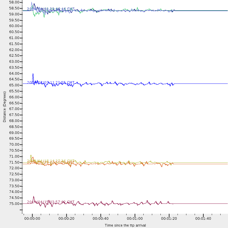
Events Used in the Stack
(7 events)| Radial Match | Distance | Baz | FERegion | Time | Lat/Lon | Depth | Magnitude |
| 98.378716 | 57.9 deg | 233.06 deg | Near Coast Of Northern Chile | 2014/04/01 23:46:46 GMT | (-19.6, -70.8) | 20 km | 8.2 MWW, 8.0 MI, 8.1 MWC |
| 92.126434 | 64.7 deg | 278.62 deg | Near Coast Of Chiapas, Mexico | 2014/07/07 11:23:55 GMT | (14.7, -92.4) | 60 km | 6.9 MWW, 6.9 MWC, 7.1 MI |
| 89.891556 | 72.0 deg | 283.38 deg | Guerrero, Mexico | 2014/04/18 14:27:26 GMT | (17.6, -100.8) | 24 km | 7.2 MWW, 7.0 MWB, 7.3 MWC, 7.5 MI |
| 88.97009 | 57.9 deg | 232.667 deg | Near Coast Of Northern Chile | 2014/03/16 21:16:30 GMT | (-19.9, -70.6) | 20 km | 6.7 MWW, 6.7 MWC, 7.0 MI |
| 88.69372 | 72.1 deg | 182.107 deg | South Sandwich Islands Region | 2014/06/29 07:52:56 GMT | (-55.5, -28.5) | 16 km | 6.9 MWW, 7.2 MI |
| 87.53248 | 57.8 deg | 233.07 deg | Near Coast Of Northern Chile | 2014/04/02 00:06:44 GMT | (-19.6, -70.8) | 10 km | 5.7 MB |
| 87.30021 | 75.8 deg | 160.06 deg | Bouvet Island Region | 2014/04/15 03:57:02 GMT | (-53.5, 8.7) | 12 km | 6.9 MWP, 6.8 MI, 6.9 MI |
Losers
(28 events)| Radial Match | Distance | Baz | FERegion | Time | Lat/Lon | Depth | Magnitude | Reason |
| 88.58847 | 58.1 deg | 232.02 deg | Near Coast Of Northern Chile | 2014/04/03 02:43:14 GMT | (-20.5, -70.5) | 31 km | 7.7 MWW, 7.4 MI, 7.7 MWC | |
| 78.29396 | 58.5 deg | 232.214 deg | Near Coast Of Northern Chile | 2014/04/11 08:39:43 GMT | (-20.6, -71.0) | 13 km | 4.9 mb | |
| 76.66212 | 58.0 deg | 232.981 deg | Near Coast Of Northern Chile | 2014/03/22 12:59:59 GMT | (-19.8, -70.9) | 20 km | 6.2 MWW, 6.2 MWB, 6.3 MWC, 6.4 MWC | |
| 73.52089 | 58.3 deg | 232.092 deg | Near Coast Of Northern Chile | 2014/04/03 04:17:57 GMT | (-20.6, -70.7) | 18 km | 5.2 mb | |
| 73.13289 | 59.7 deg | 252.984 deg | Near Coast Of Northern Peru | 2014/03/15 23:51:33 GMT | (-5.6, -81.0) | 29 km | 6.3 MWW, 6.2 MWB, 6.3 MWC | |
| 71.13344 | 59.3 deg | 241.822 deg | Near Coast Of Peru | 2014/03/15 08:59:21 GMT | (-14.1, -76.3) | 20 km | 6.1 MWW, 6.0 MWB, 6.2 MWC | |
| 70.89933 | 71.9 deg | 283.174 deg | Guerrero, Mexico | 2014/05/08 17:00:17 GMT | (17.4, -100.7) | 24 km | 6.4 MWW, 6.8 MI | |
| 70.61034 | 58.4 deg | 232.08 deg | Near Coast Of Northern Chile | 2014/04/04 01:37:51 GMT | (-20.6, -70.7) | 20 km | 6.1 MWP, 6.1 MWB, 6.1 MWW, 6.3 MWC | |
| 68.00576 | 57.9 deg | 232.958 deg | Near Coast Of Northern Chile | 2014/03/23 18:20:03 GMT | (-19.7, -70.8) | 35 km | 6.0 MB, 6.2 MWB, 6.2 MWW, 6.3 MWC | |
| 66.55727 | 59.3 deg | 273.661 deg | Near Coast Of Nicaragua | 2014/04/11 20:29:13 GMT | (11.6, -86.0) | 135 km | 6.6 MWW, 6.6 MWC, 6.6 MWB, 6.6 MI | |
| 64.99055 | 57.9 deg | 232.477 deg | Near Coast Of Northern Chile | 2014/04/11 12:00:51 GMT | (-20.1, -70.5) | 22 km | 5.5 MB | |
| 64.655174 | 58.0 deg | 232.726 deg | Near Coast Of Northern Chile | 2014/03/18 21:26:45 GMT | (-20.0, -70.8) | 3.8 km | 5.8 MWW, 5.9 MWC, 6.0 MWR, 6.0 MWB | |
| 62.416237 | 73.6 deg | 180.127 deg | South Sandwich Islands Region | 2014/05/19 22:47:12 GMT | (-57.0, -25.1) | 10 km | 5.7 MWW, 5.7 MWC | |
| 62.11918 | 57.3 deg | 232.775 deg | Near Coast Of Northern Chile | 2014/04/01 23:59:57 GMT | (-19.5, -70.2) | 22 km | 5.8 MB | |
| 58.773663 | 72.0 deg | 283.072 deg | Guerrero, Mexico | 2014/05/10 07:36:03 GMT | (17.3, -100.8) | 35 km | 6.0 MB | |
| 58.17512 | 58.3 deg | 231.781 deg | Near Coast Of Northern Chile | 2014/04/03 05:26:16 GMT | (-20.8, -70.5) | 24 km | 6.2 MWP, 6.2 MWR, 6.3 MWW, 6.5 MWC | |
| 56.688133 | 59.8 deg | 273.854 deg | Near Coast Of Nicaragua | 2014/03/28 14:36:08 GMT | (11.6, -86.6) | 46 km | 5.6 MWW, 5.5 MWB, 5.6 MWC | |
| 55.82559 | 58.4 deg | 231.935 deg | Near Coast Of Northern Chile | 2014/04/14 05:56:20 GMT | (-20.7, -70.7) | 30 km | 5.3 MW | |
| 54.56999 | 73.4 deg | 181.384 deg | South Sandwich Islands Region | 2014/02/01 03:58:43 GMT | (-56.8, -27.3) | 130 km | 6.1 MWW, 6.1 MWC, 6.1 MWB, 6.2 MWC | |
| 54.08704 | 67.3 deg | 221.456 deg | Near Coast Of Central Chile | 2014/03/04 10:51:15 GMT | (-33.6, -72.0) | 20 km | 5.7 MWW, 5.7 MWB, 5.8 MWC | |
| 52.779884 | 33.9 deg | 275.697 deg | Leeward Islands | 2014/05/16 11:01:42 GMT | (17.1, -60.4) | 24 km | 6.0 MWP, 6.0 MI | |
| 52.12341 | 58.3 deg | 231.882 deg | Near Coast Of Northern Chile | 2014/04/03 02:56:06 GMT | (-20.7, -70.6) | 17 km | 5.6 MB | |
| 51.93112 | 57.8 deg | 233.092 deg | Near Coast Of Northern Chile | 2014/03/24 15:45:31 GMT | (-19.6, -70.8) | 18 km | 5.6 MWB, 5.5 MWR, 5.7 MWC, 5.7 MWW | |
| 50.57125 | 66.5 deg | 221.895 deg | Near Coast Of Central Chile | 2014/04/05 02:22:38 GMT | (-32.8, -71.6) | 40 km | 5.6 MWC, 5.6 MWC | |
| 48.41324 | 58.0 deg | 232.933 deg | Near Coast Of Northern Chile | 2014/03/22 13:14:55 GMT | (-19.8, -70.9) | 4.6 km | 5.2 Mww | |
| 46.12005 | 66.6 deg | 281.764 deg | Chiapas, Mexico | 2014/05/21 10:06:14 GMT | (17.2, -94.9) | 128 km | 5.6 MWP | |
| 45.681286 | 57.9 deg | 232.186 deg | Near Coast Of Northern Chile | 2014/07/13 20:54:14 GMT | (-20.2, -70.4) | 36 km | 6.1 M | |
| 35.855595 | 63.4 deg | 171.401 deg | Southern Mid-Atlantic Ridge | 2014/06/13 19:30:30 GMT | (-46.0, -13.9) | 10 km | 5.7 MB, 5.6 MWB, 5.8 MWC |

