
Station AF TEZI - Itezhi-tezhi, Zambia
Network: AF - Africa Array
Nearby stations (2 deg radius)
| Station | Name | (Lat, Lon) | Start / End | Elevation |
| TEZI | Itezhi-tezhi, Zambia | (-15.75, 26.02) | 2006-01-10 / 2599-12-31 | 1116 m |
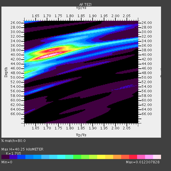
| Crust2 Type: | I1,late Proter., no seds. |
| Thickness Estimate: | 40 km |
| Thickness StdDev: | 2.0 km |
| Vp/Vs Estimate: | 1.71 |
| Vp/Vs StdDev: | 0.02 |
| Vs Estimate: | 3.896 km/s |
| Poisson's Ratio: | 0.24 |
| Peak Value: | 0.01 |
| Assumed Vp: | 6.642 km/s |
| Ps Weight: | 0.33333334 |
| PpPs Weight: | 0.33333334 |
| PsPs Weight: | 0.33333328 |
| Residual Complexity: | 0.639 |
| Nearby stations H: | +- |
| (2.0 deg) Vp/Vs: | +- |
5 with match > 90% ( 50.0 %) and 5 with match > 80% ( 50.0 %) out of 10.
Download stack as xyz text file.
Azimuth Distribution of Events:

Prior Results for this Station
| Study | Thickness | Vp/Vs | Vp | Vs | Poissons Ratio | Extra |
| EARS | 40 km | 1.71 | 6.642 km/s | 3.896 km/s | 0.24 | |
| Crust2.0 | 43 km | 1.77 | 6.642 km/s | 3.756 km/s | 0.26 | I1,late Proter., no seds. |
| Global Maxima | 40 km | 1.71 | 6.642 km/s | 3.896 km/s | 0.24 | amp=0.012307828 |
| Local Maxima 1 | 38 km | 1.72 | 6.642 km/s | 3.873 km/s | 0.24 | amp=0.008811929 |
| Local Maxima 2 | 50 km | 1.60 | 6.642 km/s | 4.151 km/s | 0.18 | amp=0.0055470765 |
| Local Maxima 3 | 48 km | 1.60 | 6.642 km/s | 4.151 km/s | 0.18 | amp=0.004174152 |
| Local Maxima 4 | 38 km | 1.81 | 6.642 km/s | 3.67 km/s | 0.28 | amp=0.0040120995 |
| Predicted Arrivals for vertical incidence (zero ray parameter) | |
| Ps | 4.27 SECOND |
| PpPs | 16.39 SECOND |
| PsPs/PpSs | 20.66 SECOND |
Events Processed for this Station
Download zip of receiver functions as SAC
Plot maxima for each earthquake.
Events Used in the Stack
(5 events)| Radial Match | Distance | Baz | FERegion | Time | Lat/Lon | Depth | Magnitude |
| 98.21809 | 72.5 deg | 53.565 deg | Nepal | 2015/05/12 07:05:19 GMT | (27.8, 86.1) | 15 km | 7.3 MWW |
| 94.665565 | 88.5 deg | 232.744 deg | Near Coast Of Central Chile | 2015/06/20 02:10:06 GMT | (-36.3, -73.8) | 10 km | 6.4 MO |
| 94.0234 | 72.1 deg | 41.29 deg | Southern Xinjiang, China | 2015/07/03 01:07:45 GMT | (37.5, 78.1) | 10 km | 6.1 MB |
| 93.8355 | 38.6 deg | 262.644 deg | Southern Mid-Atlantic Ridge | 2015/05/24 04:53:22 GMT | (-16.8, -14.2) | 10 km | 6.3 MWP |
| 91.6659 | 88.0 deg | 247.409 deg | Northern Chile | 2015/06/10 13:52:08 GMT | (-22.4, -68.3) | 122 km | 6.0 MO |
Losers
(5 events)| Radial Match | Distance | Baz | FERegion | Time | Lat/Lon | Depth | Magnitude | Reason |
| 73.29742 | 67.4 deg | 38.205 deg | Afghanistan-Tajikistan Bord Reg. | 2015/06/29 22:07:48 GMT | (36.7, 71.3) | 190 km | 5.5 MB | |
| 71.64243 | 41.6 deg | 83.99 deg | Mid-Indian Ridge | 2015/05/11 17:42:03 GMT | (-7.8, 67.8) | 15 km | 5.3 MW, 4.7 MS, 5.2 mb | |
| 68.728294 | 58.0 deg | 208.428 deg | South Sandwich Islands Region | 2015/06/20 05:32:16 GMT | (-59.6, -26.6) | 117 km | 5.6 MB | |
| 66.71869 | 57.9 deg | 208.34 deg | South Sandwich Islands Region | 2015/05/24 21:06:41 GMT | (-59.6, -26.4) | 37 km | 5.8 MB | |
| 60.41553 | 67.8 deg | 135.224 deg | Southeast Indian Ridge | 2015/05/29 08:40:13 GMT | (-47.5, 100.1) | 11 km | 5.9 MW, 5.1 mb, 5.7 MS |

