
Station AF WDLM - Western deep levels CMG-3T Earth data Low gain
Network: AF - Africa Array
Nearby stations (2 deg radius)
| Station | Name | (Lat, Lon) | Start / End | Elevation |
| WDLM | Western deep levels CMG-3T Earth data Low gain | (-26.42, 27.42) | 2009-12-08 / 2599-12-31 | 1680 m |
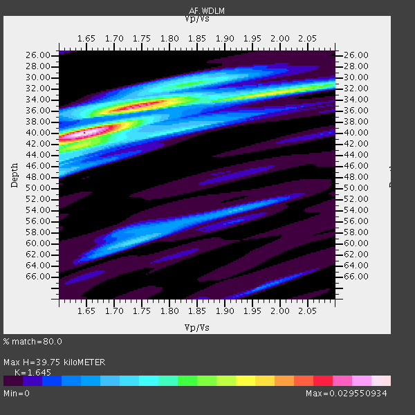
| Crust2 Type: | G1,Archean, no seds. |
| Thickness Estimate: | 40 km |
| Thickness StdDev: | 6.5 km |
| Vp/Vs Estimate: | 1.64 |
| Vp/Vs StdDev: | 0.09 |
| Vs Estimate: | 3.927 km/s |
| Poisson's Ratio: | 0.21 |
| Peak Value: | 0.03 |
| Assumed Vp: | 6.459 km/s |
| Ps Weight: | 0.33333334 |
| PpPs Weight: | 0.33333334 |
| PsPs Weight: | 0.33333328 |
| Residual Complexity: | 0.712 |
| Nearby stations H: | +- |
| (2.0 deg) Vp/Vs: | +- |
2 with match > 90% ( 12.5 %) and 4 with match > 80% ( 25.0 %) out of 16.
Download stack as xyz text file.
Azimuth Distribution of Events:

Prior Results for this Station
| Study | Thickness | Vp/Vs | Vp | Vs | Poissons Ratio | Extra |
| EARS | 40 km | 1.64 | 6.459 km/s | 3.927 km/s | 0.21 | |
| Crust2.0 | 37 km | 1.76 | 6.459 km/s | 3.665 km/s | 0.26 | G1,Archean, no seds. |
| Global Maxima | 40 km | 1.64 | 6.459 km/s | 3.927 km/s | 0.21 | amp=0.029550934 |
| Local Maxima 1 | 35 km | 1.75 | 6.459 km/s | 3.691 km/s | 0.26 | amp=0.023034438 |
| Local Maxima 2 | 33 km | 1.96 | 6.459 km/s | 3.291 km/s | 0.32 | amp=0.013878416 |
| Local Maxima 3 | 42 km | 1.69 | 6.459 km/s | 3.834 km/s | 0.23 | amp=0.009746196 |
| Local Maxima 4 | 60 km | 1.73 | 6.459 km/s | 3.728 km/s | 0.25 | amp=0.009616923 |
| Predicted Arrivals for vertical incidence (zero ray parameter) | |
| Ps | 3.97 SECOND |
| PpPs | 16.28 SECOND |
| PsPs/PpSs | 20.25 SECOND |
Events Processed for this Station
Download zip of receiver functions as SAC
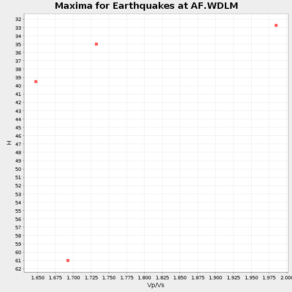
Plot maxima for each earthquake.
Events Used in the Stack
(4 events)| Radial Match | Distance | Baz | FERegion | Time | Lat/Lon | Depth | Magnitude |
| 95.84072 | 92.7 deg | 256.857 deg | Peru-Brazil Border Region | 2015/11/24 22:45:38 GMT | (-10.6, -71.0) | 602 km | 7.5 MWW, 6.9 MI |
| 95.41272 | 85.0 deg | 239.715 deg | Off Coast Of Central Chile | 2015/11/11 01:54:37 GMT | (-29.4, -72.1) | 10 km | 6.9 MWW, 6.6 MI |
| 87.46846 | 83.8 deg | 238.771 deg | Near Coast Of Central Chile | 2015/09/26 02:51:18 GMT | (-30.8, -71.4) | 38 km | 6.2 MO |
| 83.14956 | 83.9 deg | 238.632 deg | Near Coast Of Central Chile | 2015/11/07 07:31:42 GMT | (-30.9, -71.5) | 36 km | 6.8 MWP, 6.8 MI |
Losers
(12 events)| Radial Match | Distance | Baz | FERegion | Time | Lat/Lon | Depth | Magnitude | Reason |
| 97.9145 | 49.5 deg | 131.34 deg | Southeast Indian Ridge | 2015/12/04 22:24:54 GMT | (-47.7, 85.2) | 10 km | 7.1 MWP | |
| 95.47916 | 74.7 deg | 34.987 deg | Hindu Kush Region, Afghanistan | 2015/10/26 09:09:32 GMT | (36.4, 70.7) | 212 km | 7.5 MWW, 7.5 MWB | |
| 79.996315 | 84.0 deg | 238.308 deg | Near Coast Of Central Chile | 2015/09/16 23:23:26 GMT | (-31.2, -71.8) | 37 km | 5.6 MB | |
| 75.342834 | 74.9 deg | 35.207 deg | Afghanistan-Tajikistan Bord Reg. | 2015/12/25 19:14:48 GMT | (36.5, 71.1) | 204 km | 6.2 MO | |
| 73.55484 | 93.0 deg | 100.758 deg | Timor Region | 2015/11/04 03:44:15 GMT | (-8.4, 124.9) | 14 km | 6.3 MWP | |
| 71.940346 | 83.7 deg | 238.645 deg | Near Coast Of Central Chile | 2015/09/17 03:55:07 GMT | (-31.0, -71.4) | 35 km | 6.2 MO | |
| 67.25774 | 83.9 deg | 238.934 deg | Near Coast Of Central Chile | 2015/12/19 19:25:04 GMT | (-30.6, -71.4) | 46 km | 5.8 MWR | |
| 65.78552 | 44.1 deg | 116.63 deg | Mid-Indian Ridge | 2015/08/13 11:28:15 GMT | (-36.9, 78.3) | 10 km | 5.6 MWC, 5.6 MWC | |
| 63.987568 | 83.8 deg | 238.388 deg | Near Coast Of Central Chile | 2015/09/17 01:41:09 GMT | (-31.2, -71.6) | 37 km | 5.6 MB | |
| 61.36808 | 93.6 deg | 257.917 deg | Peru-Brazil Border Region | 2015/11/26 05:45:18 GMT | (-9.2, -71.3) | 604 km | 6.4 MWP | |
| 60.561554 | 84.1 deg | 238.198 deg | Near Coast Of Central Chile | 2015/09/17 04:02:10 GMT | (-31.2, -71.9) | 16 km | 5.7 mwr | |
| 58.511047 | 83.4 deg | 238.256 deg | Near Coast Of Central Chile | 2015/09/22 07:12:59 GMT | (-31.5, -71.2) | 54 km | 6.1 MWB |

