
Station AG BAT2 - Batesvile test site 2
Network: AG - Arkansas Seismic Network
Nearby stations (2 deg radius)
| Station | Name | (Lat, Lon) | Start / End | Elevation |
| BAT2 | Batesvile test site 2 | (35.89, -91.56) | 2024-01-31 / 2499-01-01 | 233 m |
| Crust2 Type: | DD,Platform 5.0 km seds. |
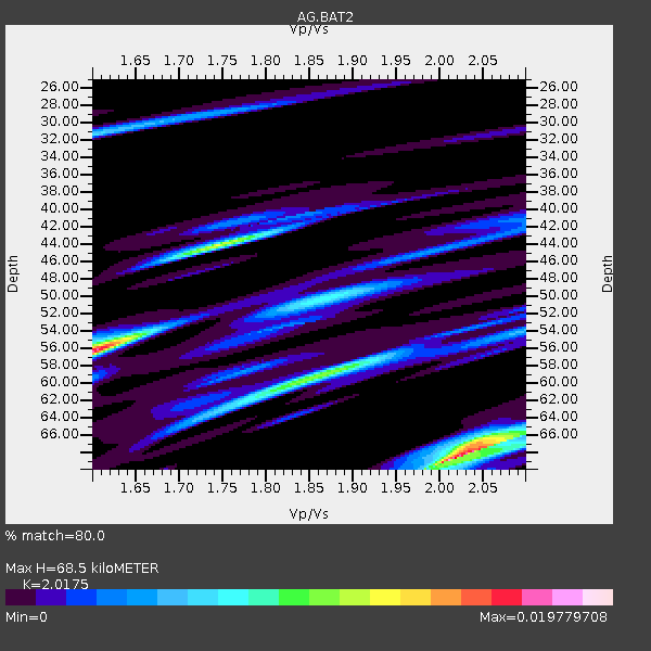
| Thickness Estimate: | 68 km |
| Thickness StdDev: | 6.9 km |
| Vp/Vs Estimate: | 2.02 |
| Vp/Vs StdDev: | 0.03 |
| Vs Estimate: | 3.109 km/s |
| Poisson's Ratio: | 0.34 |
| Peak Value: | 0.02 |
| Assumed Vp: | 6.273 km/s |
| Ps Weight: | 0.33333334 |
| PpPs Weight: | 0.33333334 |
| PsPs Weight: | 0.33333328 |
| Residual Complexity: | 0.805 |
| Nearby stations H: | +- |
| (2.0 deg) Vp/Vs: | +- |
1 with match > 90% ( 25.0 %) and 2 with match > 80% ( 50.0 %) out of 4.
Download stack as xyz text file.
Azimuth Distribution of Events:

Prior Results for this Station
| Study | Thickness | Vp/Vs | Vp | Vs | Poissons Ratio | Extra |
| EARS | 68 km | 2.02 | 6.273 km/s | 3.109 km/s | 0.34 | |
| Crust2.0 | 41 km | 1.78 | 6.273 km/s | 3.524 km/s | 0.27 | DD,Platform 5.0 km seds. |
| Global Maxima | 68 km | 2.02 | 6.273 km/s | 3.109 km/s | 0.34 | amp=0.019779708 |
| Local Maxima 1 | 56 km | 1.60 | 6.273 km/s | 3.921 km/s | 0.18 | amp=0.017055653 |
| Local Maxima 2 | 44 km | 1.75 | 6.273 km/s | 3.595 km/s | 0.26 | amp=0.011553434 |
| Local Maxima 3 | 59 km | 1.86 | 6.273 km/s | 3.368 km/s | 0.30 | amp=0.010691258 |
| Local Maxima 4 | 67 km | 2.04 | 6.273 km/s | 3.075 km/s | 0.34 | amp=0.008354634 |
| Predicted Arrivals for vertical incidence (zero ray parameter) | |
| Ps | 11.11 SECOND |
| PpPs | 32.95 SECOND |
| PsPs/PpSs | 44.06 SECOND |
Events Processed for this Station
Download zip of receiver functions as SAC
Plot maxima for each earthquake.
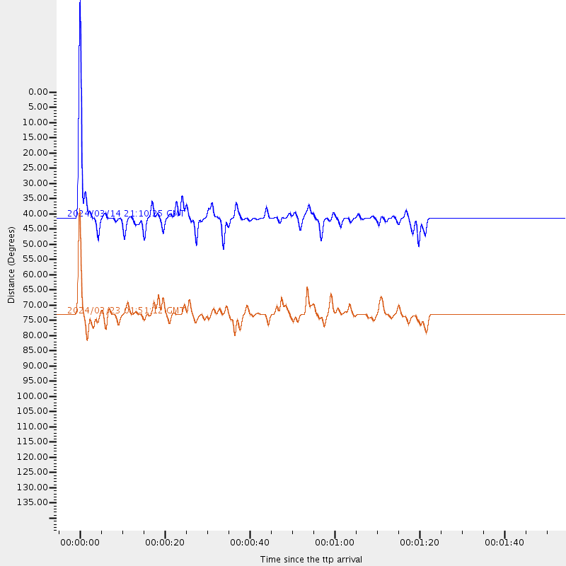
Events Used in the Stack
(2 events)| Radial Match | Distance | Baz | FERegion | Time | Lat/Lon | Depth | Magnitude |
| 91.06752 | 41.2 deg | 84.027 deg | Northern Mid-Atlantic Ridge | 2024/03/14 21:10:25 UTC | (29.8, -42.7) | 10 km | 6.0 mww |
| 88.029434 | 72.9 deg | 196.405 deg | Southern East Pacific Rise | 2024/02/23 01:51:12 UTC | (-35.1, -110.8) | 2.0 km | 6.3 Mww |
Losers
(2 events)| Radial Match | Distance | Baz | FERegion | Time | Lat/Lon | Depth | Magnitude | Reason |
| 54.74306 | 67.2 deg | 160.981 deg | Near Coast Of Central Chile | 2024/02/14 01:31:41 UTC | (-28.9, -71.5) | 22 km | 6.0 mww | |
| 46.35248 | 62.1 deg | 315.531 deg | Rat Islands, Aleutian Islands | 2024/02/28 15:50:21 UTC | (51.9, 179.6) | 119 km | 5.5 mww |

