
Station AK THY - Trims Highway
Network: AK - Alaska Regional Network
Nearby stations (2 deg radius)
| Station | Name | (Lat, Lon) | Start / End | Elevation |
| THY | Trims Highway | (63.42, -145.75) | 1986-01-01 / 2499-01-01 | 732 m |
| Crust2 Type: | L8,thin continental arc, Cordilleras, 0.5 km seds. |
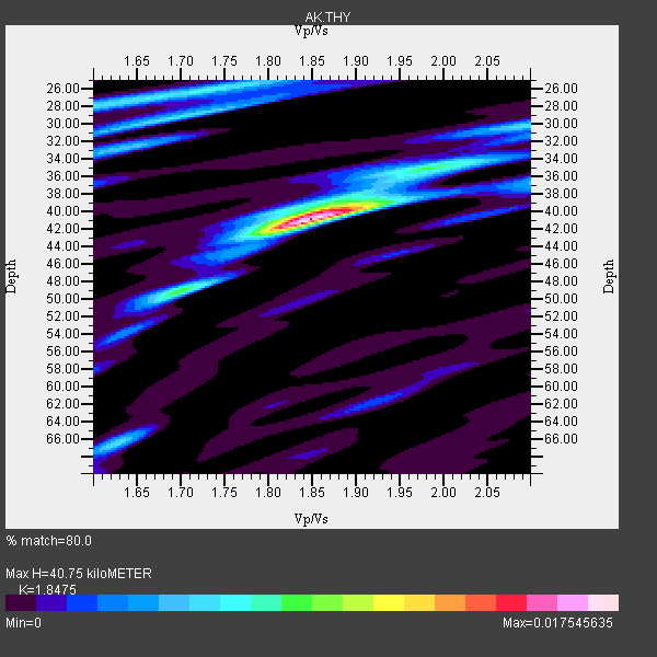
| Thickness Estimate: | 41 km |
| Thickness StdDev: | 5.2 km |
| Vp/Vs Estimate: | 1.85 |
| Vp/Vs StdDev: | 0.09 |
| Vs Estimate: | 3.554 km/s |
| Poisson's Ratio: | 0.29 |
| Peak Value: | 0.02 |
| Assumed Vp: | 6.566 km/s |
| Ps Weight: | 0.33333334 |
| PpPs Weight: | 0.33333334 |
| PsPs Weight: | 0.33333328 |
| Residual Complexity: | 0.518 |
| Nearby stations H: | +- |
| (2.0 deg) Vp/Vs: | +- |
3 with match > 90% ( 18.75 %) and 16 with match > 80% ( 100.0 %) out of 16.
Download stack as xyz text file.
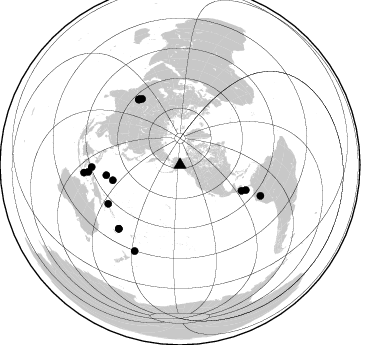
Azimuth Distribution of Events:
Prior Results for this Station
| Study | Thickness | Vp/Vs | Vp | Vs | Poissons Ratio | Extra |
| EARS | 41 km | 1.85 | 6.566 km/s | 3.554 km/s | 0.29 | |
| Crust2.0 | 34 km | 1.77 | 6.566 km/s | 3.707 km/s | 0.27 | L8,thin continental arc, Cordilleras, 0.5 km seds. |
| Global Maxima | 41 km | 1.85 | 6.566 km/s | 3.554 km/s | 0.29 | amp=0.017545635 |
| Local Maxima 1 | 26 km | 1.73 | 6.566 km/s | 3.801 km/s | 0.25 | amp=0.006528343 |
| Local Maxima 2 | 66 km | 1.62 | 6.566 km/s | 4.047 km/s | 0.19 | amp=0.005739065 |
| Local Maxima 3 | 30 km | 2.10 | 6.566 km/s | 3.13 km/s | 0.35 | amp=0.005660441 |
| Local Maxima 4 | 39 km | 1.88 | 6.566 km/s | 3.488 km/s | 0.30 | amp=0.0055029797 |
| Predicted Arrivals for vertical incidence (zero ray parameter) | |
| Ps | 5.26 SECOND |
| PpPs | 17.67 SECOND |
| PsPs/PpSs | 22.93 SECOND |
Events Processed for this Station
Download zip of receiver functions as SAC
Plot maxima for each earthquake.
Events Used in the Stack
(16 events)| Radial Match | Distance | Baz | FERegion | Time | Lat/Lon | Depth | Magnitude |
| 93.546684 | 88.2 deg | 223.741 deg | Vanuatu Islands | 2005/09/25 20:28:40 GMT | (-17.4, 167.9) | 30 km | 5.3 MB, 5.3 MS, 5.6 MW, 5.6 MW |
| 92.79876 | 77.5 deg | 327.585 deg | Pakistan | 2005/10/08 03:50:40 GMT | (34.5, 73.6) | 26 km | 6.9 MB, 7.7 MS, 7.6 MW, 7.3 MW |
| 90.64285 | 88.4 deg | 268.527 deg | Northern Molucca Sea | 2005/09/08 04:10:10 GMT | (0.8, 126.3) | 49 km | 5.6 MB, 5.2 MS, 5.7 MW, 5.6 MW |
| 89.682304 | 77.4 deg | 328.037 deg | Pakistan | 2005/10/08 10:46:28 GMT | (34.7, 73.1) | 8.0 km | 6.0 MB, 6.3 MS, 6.4 MW, 6.2 MW |
| 89.090294 | 97.0 deg | 207.819 deg | Kermadec Islands, New Zealand | 2005/11/02 03:09:18 GMT | (-30.4, -178.2) | 36 km | 5.8 MB, 5.3 MS, 5.8 MW, 5.7 MW |
| 88.01534 | 96.2 deg | 265.444 deg | Banda Sea | 2005/09/12 21:51:06 GMT | (-7.7, 125.5) | 30 km | 5.5 MB, 4.5 MS |
| 87.69185 | 66.6 deg | 112.849 deg | Near Coast Of Nicaragua | 2005/07/02 02:16:43 GMT | (11.2, -86.2) | 27 km | 5.6 MB, 6.4 MS, 6.6 MW, 6.6 MW |
| 87.63293 | 86.0 deg | 111.007 deg | Northern Peru | 2005/09/26 01:55:37 GMT | (-5.7, -76.4) | 115 km | 6.7 MB, 7.5 MW, 7.5 MW |
| 87.541176 | 76.3 deg | 330.12 deg | Afghanistan-Tajikistan Bord Reg. | 2005/12/12 21:47:46 GMT | (36.4, 71.1) | 225 km | 6.0 MB, 6.5 MW, 6.5 MW |
| 87.3982 | 88.3 deg | 223.811 deg | Vanuatu Islands | 2005/09/25 22:58:54 GMT | (-17.5, 167.8) | 30 km | 5.2 MB, 5.2 MS, 5.6 MW, 5.6 MW |
| 86.69421 | 77.5 deg | 327.952 deg | Pakistan | 2005/10/09 08:30:01 GMT | (34.7, 73.2) | 7.0 km | 5.7 MB, 5.3 MS, 5.7 MW, 5.6 MW |
| 85.1006 | 69.0 deg | 257.187 deg | Mariana Islands | 2005/04/21 21:31:48 GMT | (13.2, 145.1) | 50 km | 5.6 MB, 4.9 MS, 5.5 MW, 5.4 MW |
| 84.77934 | 81.4 deg | 241.618 deg | New Ireland Region, P.N.G. | 2005/09/09 07:26:43 GMT | (-4.5, 153.5) | 90 km | 6.3 MB, 7.7 MW, 7.5 MW |
| 82.6751 | 91.8 deg | 265.649 deg | Seram, Indonesia | 2005/11/01 21:13:32 GMT | (-3.6, 127.3) | 13 km | 5.5 MB, 5.3 MS, 5.7 MW, 5.7 MW |
| 80.55849 | 74.5 deg | 262.05 deg | W. Caroline Islands, Micronesia | 2005/09/02 18:35:12 GMT | (10.4, 138.3) | 10 km | 5.7 MB, 5.1 MS, 5.7 MW, 5.6 MW |
| 80.28016 | 70.5 deg | 110.951 deg | Panama-Costa Rica Border Region | 2005/06/30 21:26:36 GMT | (8.4, -82.9) | 38 km | 5.3 MB, 5.6 MS, 6.0 MW, 5.8 MW |
Losers
(0 events)| Radial Match | Distance | Baz | FERegion | Time | Lat/Lon | Depth | Magnitude | Reason |
