
Station AT MENT - Mentasta, Alaska
Network: AT - Alaska Tsunami Warning Seismic System
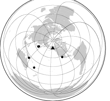
Nearby stations (2 deg radius)

| Station | Name | (Lat, Lon) | Start / End | Elevation |
| MENT | Mentasta, Alaska | (62.94, -143.72) | 2010-12-02 / 2599-12-31 | 702 m |
| Crust2 Type: | L8,thin continental arc, Cordilleras, 0.5 km seds. |
| Thickness Estimate: | 36 km |
| Thickness StdDev: | 4.9 km |
| Vp/Vs Estimate: | 1.74 |
| Vp/Vs StdDev: | 0.09 |
| Vs Estimate: | 3.785 km/s |
| Poisson's Ratio: | 0.25 |
| Peak Value: | 0.07 |
| Assumed Vp: | 6.566 km/s |
| Ps Weight: | 0.33333334 |
| PpPs Weight: | 0.33333334 |
| PsPs Weight: | 0.33333328 |
| Residual Complexity: | 0.646 |
| Nearby stations H: | +- |
| (2.0 deg) Vp/Vs: | +- |
3 with match > 90% ( 7.3170733 %) and 6 with match > 80% ( 14.634147 %) out of 41.
Download stack as xyz text file.
Azimuth Distribution of Events:
Prior Results for this Station
| Study | Thickness | Vp/Vs | Vp | Vs | Poissons Ratio | Extra |
| EARS | 36 km | 1.74 | 6.566 km/s | 3.785 km/s | 0.25 | |
| Crust2.0 | 34 km | 1.77 | 6.566 km/s | 3.707 km/s | 0.27 | L8,thin continental arc, Cordilleras, 0.5 km seds. |
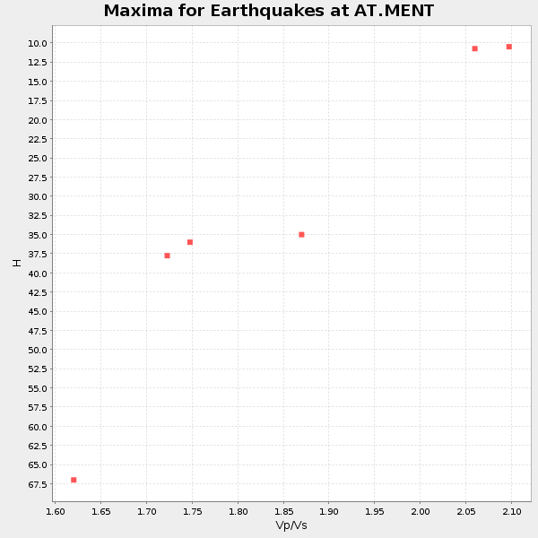
| Global Maxima | 36 km | 1.74 | 6.566 km/s | 3.785 km/s | 0.25 | amp=0.0654306 |
| Local Maxima 1 | 47 km | 1.60 | 6.566 km/s | 4.104 km/s | 0.18 | amp=0.061549798 |
| Local Maxima 2 | 44 km | 1.64 | 6.566 km/s | 4.004 km/s | 0.20 | amp=0.029275894 |
| Local Maxima 3 | 34 km | 2.00 | 6.566 km/s | 3.279 km/s | 0.33 | amp=0.015335191 |
| Local Maxima 4 | 28 km | 1.68 | 6.566 km/s | 3.92 km/s | 0.22 | amp=0.014088081 |
| Predicted Arrivals for vertical incidence (zero ray parameter) | |
| Ps | 4.06 SECOND |
| PpPs | 15.10 SECOND |
| PsPs/PpSs | 19.16 SECOND |
Events Processed for this Station
Download zip of receiver functions as SAC
Plot maxima for each earthquake.
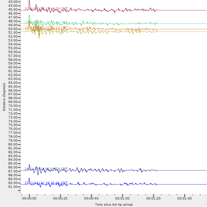
Events Used in the Stack
(6 events)| Radial Match | Distance | Baz | FERegion | Time | Lat/Lon | Depth | Magnitude |
| 94.00463 | 49.2 deg | 276.373 deg | Near East Coast Of Honshu, Japan | 2011/03/09 02:45:20 GMT | (38.4, 142.8) | 32 km | 6.4 MB, 7.3 MS, 7.5 MW, 7.3 MW |
| 91.72269 | 47.8 deg | 277.858 deg | Near East Coast Of Honshu, Japan | 2011/09/16 19:26:40 GMT | (40.3, 142.8) | 35 km | 6.0 MB, 6.5 MS, 6.7 MW, 6.7 MW |
| 90.53985 | 49.9 deg | 277.31 deg | Near East Coast Of Honshu, Japan | 2011/04/07 14:32:43 GMT | (38.3, 141.6) | 42 km | 6.9 MB, 7.0 MS, 7.1 MW, 7.1 MW |
| 85.717834 | 91.4 deg | 223.962 deg | Loyalty Islands | 2011/01/13 16:16:41 GMT | (-20.6, 168.5) | 9.0 km | 6.6 MB, 7.1 MS, 7.0 MW, 6.9 MW |
| 84.071655 | 87.6 deg | 248.333 deg | Eastern New Guinea Reg., P.N.G. | 2011/12/14 05:04:59 GMT | (-7.6, 146.8) | 141 km | 6.6 MB, 7.1 MW, 7.1 MW |
| 82.154945 | 44.1 deg | 132.926 deg | Gulf Of California | 2011/07/26 17:44:20 GMT | (25.1, -109.5) | 12 km | 5.6 MB, 5.8 MS, 6.0 MW, 6.0 MW |
Losers
(35 events)| Radial Match | Distance | Baz | FERegion | Time | Lat/Lon | Depth | Magnitude | Reason |
| 80.95457 | 49.9 deg | 275.703 deg | Off East Coast Of Honshu, Japan | 2011/03/11 06:55:33 GMT | (37.6, 142.9) | 40 km | 5.9 MB | |
| 76.6922 | 52.0 deg | 275.53 deg | Near East Coast Of Honshu, Japan | 2011/03/22 15:03:49 GMT | (35.8, 141.6) | 35 km | 6.0 MB, 5.6 MS, 5.6 MW | |
| 76.22644 | 43.1 deg | 19.123 deg | Jan Mayen Island Region | 2011/01/29 06:55:26 GMT | (70.9, -6.7) | 6.0 km | 6.1 MB, 6.1 MS, 6.2 MW, 6.2 MW | |
| 76.08771 | 59.3 deg | 121.691 deg | Off Coast Of Chiapas, Mexico | 2011/08/13 07:33:06 GMT | (14.4, -94.7) | 6.0 km | 5.7 MB, 5.2 MS, 5.8 MW, 5.6 MW | |
| 74.69398 | 60.2 deg | 271.316 deg | Bonin Islands, Japan Region | 2011/01/12 21:32:55 GMT | (27.0, 139.9) | 528 km | 6.2 MB, 6.5 MW, 6.5 MW | |
| 73.81418 | 45.0 deg | 281.134 deg | Hokkaido, Japan Region | 2011/10/21 08:02:37 GMT | (43.9, 142.5) | 187 km | 5.9 MB, 6.1 MW, 6.1 MW | |
| 71.4366 | 49.0 deg | 277.318 deg | Near East Coast Of Honshu, Japan | 2011/03/12 10:53:30 GMT | (39.0, 142.3) | 27 km | 6.0 MB, 5.4 MS, 5.7 MW, 5.7 MW | |
| 70.54443 | 49.8 deg | 274.167 deg | Off East Coast Of Honshu, Japan | 2011/03/11 17:16:56 GMT | (37.0, 144.2) | 9.3 km | 5.5 MB, 5.6 MS | |
| 69.65839 | 48.6 deg | 277.535 deg | Near East Coast Of Honshu, Japan | 2011/03/12 14:43:10 GMT | (39.5, 142.4) | 35 km | 5.7 MB, 5.5 MS, 5.8 MW | |
| 68.896835 | 48.6 deg | 276.811 deg | Near East Coast Of Honshu, Japan | 2011/03/11 08:33:00 GMT | (39.1, 143.0) | 28 km | 6.0 MB | |
| 65.98297 | 93.0 deg | 116.111 deg | Near Coast Of Peru | 2011/10/28 18:54:34 GMT | (-14.4, -76.0) | 24 km | 6.5 MB, 6.9 MS, 6.9 MW, 6.9 MW | |
| 63.45854 | 88.3 deg | 209.382 deg | Tonga Islands Region | 2011/01/31 06:03:27 GMT | (-22.0, -175.6) | 76 km | 6.0 MB, 6.0 MW, 6.0 MW | |
| 61.380352 | 64.3 deg | 260.996 deg | Mariana Islands | 2011/06/26 09:19:48 GMT | (18.9, 146.3) | 99 km | 5.6 MB, 5.5 MW, 5.5 MW | |
| 60.71969 | 97.4 deg | 209.39 deg | Kermadec Islands, New Zealand | 2011/05/21 21:17:02 GMT | (-30.8, -178.2) | 34 km | 5.5 MB, 5.4 MS, 5.8 MW, 5.8 MW | |
| 59.862167 | 51.6 deg | 275.544 deg | Near East Coast Of Honshu, Japan | 2011/03/11 13:34:30 GMT | (36.2, 141.8) | 4.7 km | 5.5 MB | |
| 58.96402 | 55.6 deg | 124.71 deg | Near Coast Of Guerrero, Mexico | 2011/05/05 13:24:07 GMT | (16.8, -98.6) | 24 km | 5.7 MW, 5.4 MS, 5.4 MB, 5.5 MW | |
| 58.11828 | 50.8 deg | 277.057 deg | Near East Coast Of Honshu, Japan | 2011/03/11 08:31:09 GMT | (37.5, 141.2) | 37 km | 6.0 MB | |
| 55.59992 | 83.1 deg | 229.231 deg | Santa Cruz Islands | 2011/01/26 17:03:30 GMT | (-11.0, 166.3) | 148 km | 5.8 MB, 5.7 MW | |
| 54.535877 | 51.7 deg | 275.737 deg | Near East Coast Of Honshu, Japan | 2011/03/11 12:49:02 GMT | (36.1, 141.6) | 35 km | 5.6 MB | |
| 53.224075 | 51.9 deg | 275.57 deg | Near East Coast Of Honshu, Japan | 2011/03/11 09:37:04 GMT | (35.9, 141.6) | 5.8 km | 5.5 MB | |
| 53.001617 | 60.3 deg | 119.317 deg | Near Coast Of Chiapas, Mexico | 2011/03/27 06:20:56 GMT | (14.4, -92.3) | 35 km | 5.7 MW, 5.3 MS, 5.3 MB, 5.7 MW | |
| 51.671005 | 97.1 deg | 302.562 deg | Nicobar Islands, India Region | 2011/11/30 19:42:34 GMT | (7.8, 93.9) | 17 km | 5.5 MB, 5.2 MS, 5.6 MW, 5.5 MW | |
| 51.281025 | 87.2 deg | 248.396 deg | Eastern New Guinea Reg., P.N.G. | 2011/05/20 19:43:16 GMT | (-7.2, 146.9) | 7.0 km | 6.2 MB, 5.5 MS, 5.7 MW, 5.7 MW | |
| 50.93834 | 50.4 deg | 275.359 deg | Off East Coast Of Honshu, Japan | 2011/03/11 07:59:48 GMT | (37.0, 142.8) | 0.7 km | 5.7 MB | |
| 50.2264 | 71.7 deg | 257.018 deg | E. Caroline Islands, Micronesia | 2011/11/09 21:52:20 GMT | (10.5, 146.1) | 10 km | 5.6 MB, 5.4 MS, 5.7 MW, 5.5 MW | |
| 48.780132 | 51.4 deg | 275.693 deg | Near East Coast Of Honshu, Japan | 2011/03/11 15:20:08 GMT | (36.4, 141.9) | 53 km | 6.0 MB | |
| 39.359966 | 87.5 deg | 212.43 deg | Fiji Islands Region | 2011/05/04 16:13:28 GMT | (-20.4, -178.5) | 584 km | 5.6 MW, 5.2 MB, 5.6 MW | |
| 35.461575 | 50.5 deg | 277.063 deg | Near East Coast Of Honshu, Japan | 2011/07/24 18:51:24 GMT | (37.7, 141.4) | 35 km | 6.3 MB, 5.9 MS, 6.3 MW, 6.3 MW | |
| 34.585503 | 47.4 deg | 277.273 deg | Off East Coast Of Honshu, Japan | 2011/04/21 00:39:03 GMT | (40.3, 143.5) | 10 km | 5.7 MW, 5.2 MS, 5.4 MB, 5.6 MW | |
| 34.423313 | 52.4 deg | 277.554 deg | Eastern Honshu, Japan | 2011/04/16 02:19:30 GMT | (36.4, 139.7) | 77 km | 5.9 MB, 5.8 MW, 5.8 MW | |
| 29.373072 | 67.5 deg | 113.42 deg | Costa Rica | 2011/05/13 22:47:54 GMT | (10.0, -84.3) | 73 km | 5.6 MB, 5.9 MW, 6.0 MW | |
| 25.669973 | 71.2 deg | 112.926 deg | South Of Panama | 2011/04/30 08:19:16 GMT | (6.9, -82.3) | 8.0 km | 5.8 MB, 5.7 MS, 6.2 MW, 6.0 MW | |
| 25.134422 | 83.4 deg | 212.003 deg | Fiji Islands Region | 2011/08/19 03:54:26 GMT | (-16.5, -177.0) | 408 km | 5.5 MB, 6.2 MW, 6.2 MW | |
| 22.675743 | 85.2 deg | 252.389 deg | Near N Coast Of New Guinea, P.N.G. | 2011/09/12 22:44:28 GMT | (-3.6, 144.2) | 14 km | 5.8 MB, 5.7 MS, 6.0 MW, 6.0 MW | |
| 20.0217 | 83.8 deg | 229.76 deg | Santa Cruz Islands | 2011/06/21 02:04:15 GMT | (-11.5, 165.6) | 14 km | 5.8 MB, 5.8 MS, 6.0 MW, 6.0 MW |
