
Station AV EDNW - Edgecumbe Northwest Ridge, Edgecumbe Volcano, Alaska
Network: AV - Alaska Volcano Observatory
Nearby stations (2 deg radius)
| Station | Name | (Lat, Lon) | Start / End | Elevation |
| EDNW | Edgecumbe Northwest Ridge, Edgecumbe Volcano, Alaska | (57.06, -135.78) | 2023-07-21 / 2499-01-01 | 380 m |
| Crust2 Type: | T6,Margin /shield transition, 1 km seds. |
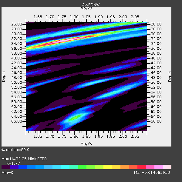
| Thickness Estimate: | 27 km |
| Thickness StdDev: | 12 km |
| Vp/Vs Estimate: | 2.10 |
| Vp/Vs StdDev: | 0.21 |
| Vs Estimate: | 3.086 km/s |
| Poisson's Ratio: | 0.35 |
| Peak Value: | 0.02 |
| Assumed Vp: | 6.472 km/s |
| Ps Weight: | 0.33333334 |
| PpPs Weight: | 0.33333334 |
| PsPs Weight: | 0.33333328 |
| Residual Complexity: | 0.572 |
| Nearby stations H: | +- |
| (2.0 deg) Vp/Vs: | +- |
8 with match > 90% ( 23.529411 %) and 10 with match > 80% ( 29.411764 %) out of 34.
Download stack as xyz text file.
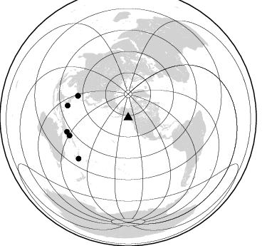
Azimuth Distribution of Events:
Prior Results for this Station
| Study | Thickness | Vp/Vs | Vp | Vs | Poissons Ratio | Extra |
| EARS | 27 km | 2.10 | 6.472 km/s | 3.086 km/s | 0.35 | |
| Crust2.0 | 32 km | 1.79 | 6.472 km/s | 3.622 km/s | 0.27 | T6,Margin /shield transition, 1 km seds. |
| Global Maxima | 27 km | 2.10 | 6.472 km/s | 3.086 km/s | 0.35 | amp=0.015450928 |
| Local Maxima 1 | 33 km | 1.60 | 6.472 km/s | 4.045 km/s | 0.18 | amp=0.008600319 |
| Local Maxima 2 | 50 km | 1.89 | 6.472 km/s | 3.424 km/s | 0.31 | amp=0.0052040154 |
| Local Maxima 3 | 46 km | 1.67 | 6.472 km/s | 3.875 km/s | 0.22 | amp=0.0047567617 |
| Local Maxima 4 | 36 km | 1.60 | 6.472 km/s | 4.045 km/s | 0.18 | amp=0.0037417272 |
| Predicted Arrivals for vertical incidence (zero ray parameter) | |
| Ps | 4.62 SECOND |
| PpPs | 13.04 SECOND |
| PsPs/PpSs | 17.66 SECOND |
Events Processed for this Station
Download zip of receiver functions as SAC
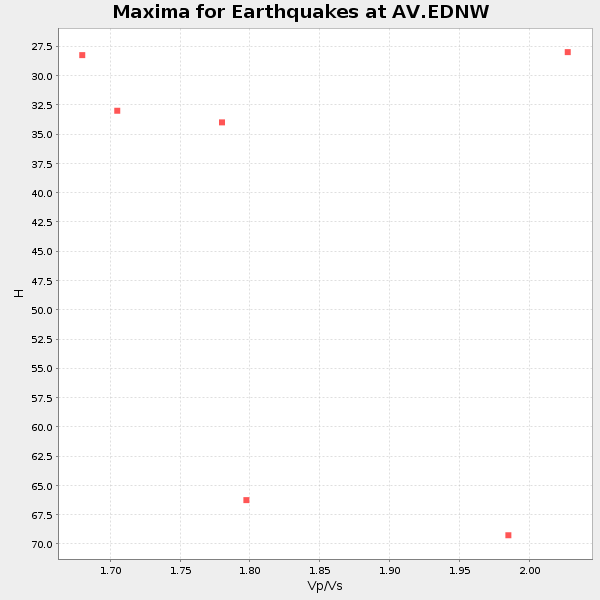
Plot maxima for each earthquake.
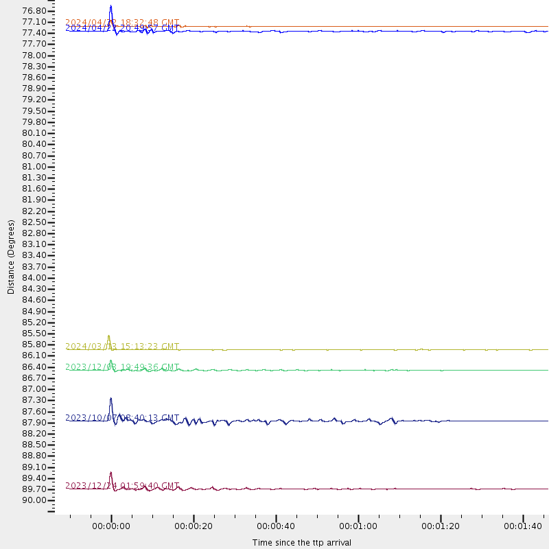
Events Used in the Stack
(10 events)| Radial Match | Distance | Baz | FERegion | Time | Lat/Lon | Depth | Magnitude |
| 99.794975 | 83.2 deg | 217.757 deg | Tonga Islands | 2024/05/05 07:13:39 UTC | (-19.4, -175.9) | 10 km | 5.7 mww |
| 99.52847 | 85.6 deg | 233.612 deg | Vanuatu Islands | 2024/05/08 08:17:15 UTC | (-15.1, 168.0) | 12 km | 6.1 mww |
| 98.166595 | 86.1 deg | 253.04 deg | New Britain Region, P.N.G. | 2024/03/13 15:13:23 UTC | (-5.9, 150.6) | 50 km | 6.0 mww |
| 97.20175 | 77.0 deg | 293.312 deg | Taiwan | 2024/04/22 20:49:57 UTC | (23.7, 121.6) | 17 km | 5.5 Mww |
| 96.377815 | 90.0 deg | 230.41 deg | Loyalty Islands | 2023/12/24 01:59:40 UTC | (-20.5, 168.9) | 10 km | 5.8 mww |
| 96.08403 | 86.7 deg | 281.199 deg | Mindanao, Philippines | 2023/12/03 19:49:36 UTC | (9.0, 126.6) | 29 km | 6.9 Mww |
| 95.217155 | 76.9 deg | 293.464 deg | Taiwan | 2024/04/22 18:32:48 UTC | (23.9, 121.6) | 10 km | 6.1 Mww |
| 90.98074 | 71.9 deg | 98.304 deg | Near Coast Of Venezuela | 2024/06/23 03:58:00 UTC | (10.8, -62.6) | 87 km | 6.0 mww |
| 87.30143 | 88.1 deg | 257.007 deg | Eastern New Guinea Reg., P.N.G. | 2023/10/07 08:40:13 UTC | (-5.5, 146.2) | 74 km | 6.7 Mww |
| 84.18871 | 88.5 deg | 122.332 deg | Near Coast Of Peru | 2024/06/28 05:36:37 UTC | (-15.8, -74.4) | 28 km | 7.2 mww |
Losers
(24 events)| Radial Match | Distance | Baz | FERegion | Time | Lat/Lon | Depth | Magnitude | Reason |
| 99.62039 | 86.9 deg | 253.748 deg | New Britain Region, P.N.G. | 2023/09/14 19:58:44 UTC | (-6.2, 149.6) | 62 km | 5.6 mww | |
| 97.35959 | 82.6 deg | 115.682 deg | Western Brazil | 2024/01/20 21:31:07 UTC | (-7.3, -71.5) | 629 km | 6.5 Mww | |
| 93.88845 | 84.3 deg | 329.139 deg | Xizang | 2024/04/13 05:44:39 UTC | (33.5, 81.9) | 10 km | 5.5 mb | |
| 85.77076 | 98.2 deg | 122.976 deg | Near Coast Of Northern Chile | 2023/11/27 10:08:25 UTC | (-24.6, -70.0) | 61 km | 5.0 Mwr | |
| 82.54988 | 88.4 deg | 257.162 deg | Eastern New Guinea Reg., P.N.G. | 2023/10/07 14:13:36 UTC | (-5.6, 145.9) | 62 km | 5.5 mb | |
| 74.54716 | 88.2 deg | 257.198 deg | Eastern New Guinea Reg., P.N.G. | 2023/10/07 09:18:50 UTC | (-5.5, 146.0) | 69 km | 5.6 mb | |
| 60.456818 | 58.0 deg | 290.41 deg | Near West Coast Of Honshu, Japan | 2024/06/02 21:31:38 UTC | (37.5, 137.2) | 4.8 km | 5.8 mww | |
| 57.545277 | 82.9 deg | 216.859 deg | Tonga Islands | 2024/05/26 20:47:09 UTC | (-19.4, -174.9) | 112 km | 6.6 mww | |
| 56.730553 | 64.3 deg | 282.797 deg | Bonin Islands, Japan Region | 2023/10/03 19:16:58 UTC | (28.4, 138.8) | 517 km | 5.3 Mww | |
| 55.481224 | 62.3 deg | 283.028 deg | Southeast Of Honshu, Japan | 2023/10/05 06:22:12 UTC | (30.1, 140.0) | 10 km | 5.6 Mww | |
| 52.54693 | 85.0 deg | 234.828 deg | Vanuatu Islands | 2023/09/21 21:11:49 UTC | (-14.0, 167.2) | 188 km | 6.1 mww | |
| 51.758457 | 62.4 deg | 282.968 deg | Southeast Of Honshu, Japan | 2023/10/05 01:59:58 UTC | (30.0, 139.9) | 10 km | 6.1 mww | |
| 51.627113 | 96.9 deg | 214.675 deg | South Of Kermadec Islands | 2023/09/08 09:09:50 UTC | (-33.3, -178.2) | 84 km | 6.6 Mi | |
| 51.566055 | 80.9 deg | 291.208 deg | Philippine Islands Region | 2023/09/12 11:03:18 UTC | (19.3, 121.2) | 41 km | 6.3 Mww | |
| 51.27343 | 66.1 deg | 147.131 deg | Central East Pacific Rise | 2023/09/20 15:03:36 UTC | (-4.7, -105.9) | 10 km | 5.7 mww | |
| 49.865738 | 84.4 deg | 251.554 deg | New Britain Region, P.N.G. | 2023/09/28 19:21:17 UTC | (-5.3, 152.8) | 49 km | 5.7 Mww | |
| 49.744896 | 96.7 deg | 215.767 deg | South Of Kermadec Islands | 2023/09/08 09:09:58 UTC | (-32.7, -179.3) | 90 km | 6.6 mww | |
| 49.407288 | 62.4 deg | 282.918 deg | Southeast Of Honshu, Japan | 2023/10/05 02:06:32 UTC | (29.9, 139.9) | 10 km | 5.4 Mww | |
| 48.111866 | 43.7 deg | 295.083 deg | Sea Of Okhotsk | 2024/06/06 11:07:53 UTC | (50.1, 147.6) | 622 km | 5.9 mww | |
| 47.408443 | 94.9 deg | 349.464 deg | Southern Iran | 2023/10/17 16:26:49 UTC | (27.7, 56.1) | 10 km | 5.4 Mww | |
| 47.156437 | 87.5 deg | 345.331 deg | Northwestern Afghanistan | 2023/10/11 00:41:56 UTC | (34.6, 62.1) | 10 km | 6.3 Mww | |
| 46.607853 | 90.0 deg | 279.721 deg | Mindanao, Philippines | 2023/10/04 11:21:48 UTC | (5.3, 126.1) | 122 km | 6.4 mww | |
| 46.399803 | 77.1 deg | 118.54 deg | Northern Peru | 2024/06/18 02:22:09 UTC | (-3.9, -76.7) | 100 km | 5.5 Mww | |
| 40.23541 | 44.0 deg | 136.142 deg | Near Coast Of Jalisco, Mexico | 2023/09/08 15:53:17 UTC | (19.3, -105.1) | 5.4 km | 5.6 mww |

