
Station AV VNWF - West Flank, Mount Veniaminof, Alaska
Network: AV - Alaska Volcano Observatory
Nearby stations (2 deg radius)
| Station | Name | (Lat, Lon) | Start / End | Elevation |
| VNWF | West Flank, Mount Veniaminof, Alaska | (56.15, -159.56) | 2002-02-06 / 2499-01-01 | 1095 m |
| Crust2 Type: | C3,continental shelf, 2 km seds. |
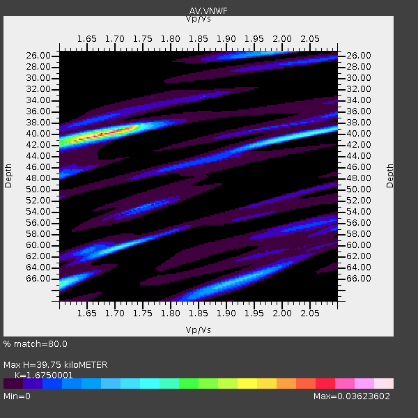
| Thickness Estimate: | 40 km |
| Thickness StdDev: | 7.7 km |
| Vp/Vs Estimate: | 1.68 |
| Vp/Vs StdDev: | 0.05 |
| Vs Estimate: | 3.662 km/s |
| Poisson's Ratio: | 0.22 |
| Peak Value: | 0.04 |
| Assumed Vp: | 6.134 km/s |
| Ps Weight: | 0.33333334 |
| PpPs Weight: | 0.33333334 |
| PsPs Weight: | 0.33333328 |
| Residual Complexity: | 0.626 |
| Nearby stations H: | +- |
| (2.0 deg) Vp/Vs: | +- |
2 with match > 90% ( 1.6949153 %) and 4 with match > 80% ( 3.3898306 %) out of 118.
Download stack as xyz text file.
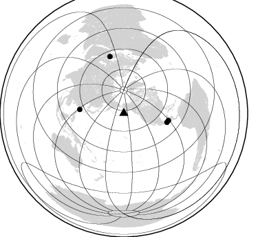
Azimuth Distribution of Events:
Prior Results for this Station
| Study | Thickness | Vp/Vs | Vp | Vs | Poissons Ratio | Extra |
| EARS | 40 km | 1.68 | 6.134 km/s | 3.662 km/s | 0.22 | |
| Crust2.0 | 31 km | 1.80 | 6.134 km/s | 3.406 km/s | 0.28 | C3,continental shelf, 2 km seds. |
| Global Maxima | 40 km | 1.68 | 6.134 km/s | 3.662 km/s | 0.22 | amp=0.03623602 |
| Local Maxima 1 | 67 km | 1.60 | 6.134 km/s | 3.834 km/s | 0.18 | amp=0.015304914 |
| Local Maxima 2 | 60 km | 1.71 | 6.134 km/s | 3.587 km/s | 0.24 | amp=0.013231129 |
| Local Maxima 3 | 40 km | 2.05 | 6.134 km/s | 2.996 km/s | 0.34 | amp=0.011945009 |
| Local Maxima 4 | 66 km | 1.93 | 6.134 km/s | 3.178 km/s | 0.32 | amp=0.010541457 |
| Predicted Arrivals for vertical incidence (zero ray parameter) | |
| Ps | 4.37 SECOND |
| PpPs | 17.34 SECOND |
| PsPs/PpSs | 21.71 SECOND |
Events Processed for this Station
Download zip of receiver functions as SAC
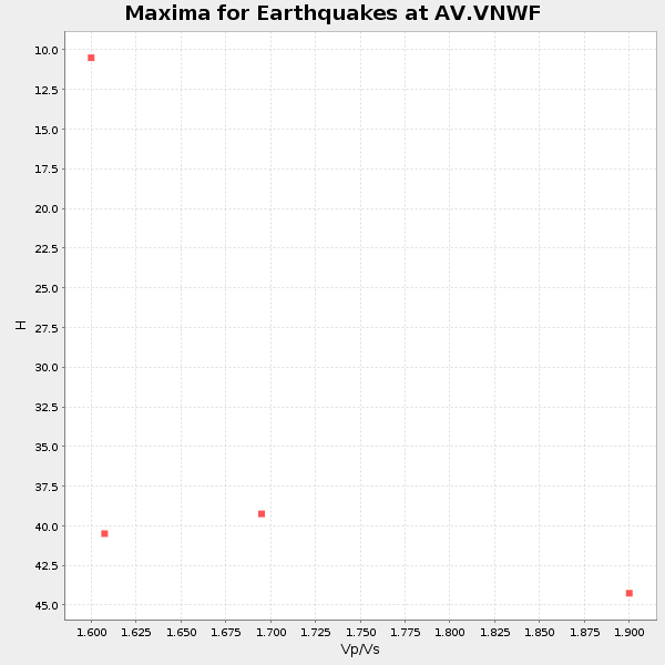
Plot maxima for each earthquake.
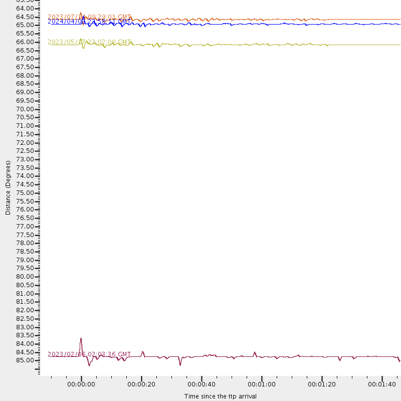
Events Used in the Stack
(4 events)| Radial Match | Distance | Baz | FERegion | Time | Lat/Lon | Depth | Magnitude |
| 94.154915 | 85.3 deg | 346.179 deg | Turkey | 2023/02/06 02:03:36 UTC | (37.8, 37.9) | 10 km | 5.5 mb |
| 91.31973 | 64.4 deg | 274.977 deg | Taiwan | 2024/04/02 23:58:11 UTC | (23.8, 121.6) | 35 km | 7.4 mww |
| 84.39822 | 64.1 deg | 101.893 deg | Near Coast Of Chiapas, Mexico | 2023/07/14 09:29:01 UTC | (15.0, -93.9) | 35 km | 6.3 mww |
| 82.92525 | 65.7 deg | 99.189 deg | Guatemala | 2023/05/17 23:02:00 UTC | (15.1, -90.9) | 256 km | 6.4 mww |
Losers
(114 events)| Radial Match | Distance | Baz | FERegion | Time | Lat/Lon | Depth | Magnitude | Reason |
| 95.51327 | 82.9 deg | 207.671 deg | Southeast Of Loyalty Islands | 2023/05/20 01:51:01 UTC | (-23.1, 170.4) | 45 km | 7.4 Mi | |
| 94.518326 | 92.2 deg | 261.173 deg | Bali Sea | 2023/08/28 19:55:31 UTC | (-6.8, 116.5) | 514 km | 7.1 Mww | |
| 94.23044 | 83.0 deg | 207.42 deg | Southeast Of Loyalty Islands | 2023/05/19 02:57:07 UTC | (-23.2, 170.7) | 10 km | 7.7 Mi | |
| 93.5713 | 76.1 deg | 239.736 deg | New Guinea, Papua New Guinea | 2023/04/02 18:04:12 UTC | (-4.3, 143.2) | 74 km | 7.3 Mi | |
| 93.34946 | 78.5 deg | 257.607 deg | Northern Molucca Sea | 2023/01/18 06:06:11 UTC | (2.7, 127.1) | 29 km | 7.0 mwc | |
| 92.920586 | 75.9 deg | 192.2 deg | Tonga Islands Region | 2022/11/11 10:48:45 UTC | (-19.3, -172.1) | 25 km | 7.3 Mww | |
| 92.597435 | 74.1 deg | 261.405 deg | Mindanao, Philippines | 2023/12/02 14:37:03 UTC | (8.5, 126.4) | 33 km | 7.6 mww | |
| 90.80913 | 77.3 deg | 260.937 deg | Mindanao, Philippines | 2023/11/17 08:14:11 UTC | (5.6, 125.0) | 64 km | 6.7 Mww | |
| 90.05559 | 87.2 deg | 195.849 deg | Kermadec Islands, New Zealand | 2023/04/24 00:41:54 UTC | (-30.0, -177.9) | 34 km | 7.3 mww | |
| 89.821724 | 74.0 deg | 222.21 deg | Solomon Islands | 2022/11/22 02:37:57 UTC | (-9.9, 159.5) | 10 km | 6.0 Mww | |
| 89.69992 | 85.1 deg | 249.771 deg | Tanimbar Islands Reg., Indonesia | 2023/01/09 17:47:34 UTC | (-7.1, 130.0) | 95 km | 7.6 mww | |
| 88.43141 | 55.1 deg | 250.997 deg | Mariana Islands | 2024/04/05 11:03:16 UTC | (19.1, 145.4) | 222 km | 6.8 mww | |
| 88.423904 | 75.7 deg | 236.486 deg | Eastern New Guinea Reg., P.N.G. | 2023/10/07 08:40:13 UTC | (-5.5, 146.2) | 74 km | 6.7 Mww | |
| 87.46302 | 72.6 deg | 195.196 deg | Tonga Islands | 2023/05/10 16:02:00 UTC | (-15.6, -174.6) | 210 km | 7.6 mww | |
| 86.99806 | 75.8 deg | 236.474 deg | Eastern New Guinea Reg., P.N.G. | 2023/10/07 08:34:26 UTC | (-5.6, 146.1) | 53 km | 6.7 mww | |
| 85.68808 | 58.7 deg | 245.242 deg | South Of Mariana Islands | 2023/08/14 13:51:54 UTC | (13.4, 147.5) | 10 km | 6.1 mww | |
| 83.795815 | 86.8 deg | 196.71 deg | Kermadec Islands, New Zealand | 2023/03/04 06:41:22 UTC | (-29.5, -178.8) | 206 km | 6.9 mww | |
| 83.533195 | 75.7 deg | 212.454 deg | Vanuatu Islands | 2023/07/26 12:44:35 UTC | (-14.8, 167.9) | 13 km | 6.4 mww | |
| 82.29567 | 80.2 deg | 196.465 deg | South Of Fiji Islands | 2023/06/15 18:06:27 UTC | (-23.0, -177.2) | 167 km | 7.2 Mww | |
| 81.98853 | 87.2 deg | 194.063 deg | Kermadec Islands Region | 2023/03/16 00:55:58 UTC | (-30.2, -175.9) | 10 km | 7.1 Mi | |
| 81.56578 | 75.3 deg | 235.91 deg | Eastern New Guinea Reg., P.N.G. | 2023/03/14 00:49:08 UTC | (-5.4, 146.9) | 213 km | 6.3 mww | |
| 80.80902 | 73.9 deg | 222.133 deg | Solomon Islands | 2022/11/22 02:03:07 UTC | (-9.8, 159.6) | 14 km | 7.0 Mww | |
| 80.71797 | 76.6 deg | 258.343 deg | Talaud Islands, Indonesia | 2023/09/26 01:39:44 UTC | (4.7, 127.5) | 100 km | 5.9 mww | |
| 79.71256 | 77.2 deg | 259.421 deg | Talaud Islands, Indonesia | 2024/01/08 20:48:46 UTC | (4.9, 126.3) | 91 km | 7.0 Mi | |
| 79.60976 | 72.9 deg | 269.337 deg | Mindoro, Philippines | 2023/06/15 02:19:25 UTC | (13.8, 120.7) | 124 km | 6.2 mww | |
| 78.57825 | 57.0 deg | 247.413 deg | Mariana Islands | 2024/04/02 09:54:09 UTC | (15.8, 146.9) | 10 km | 6.2 mww | |
| 78.56357 | 77.1 deg | 239.549 deg | New Guinea, Papua New Guinea | 2023/09/05 15:03:17 UTC | (-5.3, 142.9) | 52 km | 5.8 mww | |
| 77.77947 | 76.6 deg | 96.382 deg | South Of Panama | 2023/04/04 22:18:12 UTC | (7.6, -82.3) | 10 km | 6.3 mww | |
| 77.5398 | 67.7 deg | 100.674 deg | Off Coast Of Central America | 2023/07/30 01:10:29 UTC | (12.7, -90.9) | 10 km | 5.7 Mww | |
| 77.06845 | 71.1 deg | 317.35 deg | Kyrgyzstan-Xinjiang Border Reg. | 2024/01/22 18:42:33 UTC | (41.3, 78.8) | 10 km | 5.5 mb | |
| 76.4497 | 71.8 deg | 193.674 deg | Tonga Islands | 2023/08/08 18:38:56 UTC | (-15.0, -173.0) | 120 km | 6.2 Mi | |
| 76.3893 | 78.3 deg | 320.742 deg | Hindu Kush Region, Afghanistan | 2023/01/05 14:25:52 UTC | (36.5, 70.7) | 194 km | 5.9 mww | |
| 75.37952 | 82.9 deg | 259.359 deg | Minahassa Peninsula, Sulawesi | 2023/01/18 00:34:43 UTC | (-0.0, 123.2) | 147 km | 6.1 mww | |
| 75.309006 | 44.8 deg | 268.725 deg | Near East Coast Of Honshu, Japan | 2023/05/26 10:03:24 UTC | (35.6, 140.7) | 44 km | 6.2 mww | |
| 75.24065 | 78.2 deg | 320.551 deg | Hindu Kush Region, Afghanistan | 2023/03/21 16:47:23 UTC | (36.5, 71.0) | 188 km | 6.5 Mww | |
| 74.85106 | 81.9 deg | 257.606 deg | Southern Molucca Sea | 2024/03/13 18:56:13 UTC | (-0.1, 125.2) | 26 km | 5.8 mww | |
| 74.81511 | 76.0 deg | 240.003 deg | New Guinea, Papua New Guinea | 2024/03/23 20:22:07 UTC | (-4.1, 143.0) | 64 km | 7.0 Mi | |
| 74.16535 | 70.3 deg | 265.268 deg | Philippine Islands Region | 2023/04/04 12:54:32 UTC | (13.8, 125.5) | 15 km | 6.2 mww | |
| 73.773834 | 74.0 deg | 261.077 deg | Mindanao, Philippines | 2023/12/02 20:52:15 UTC | (8.4, 126.8) | 9.0 km | 6.0 Mww | |
| 73.546455 | 54.1 deg | 251.565 deg | Mariana Islands | 2023/11/24 09:05:03 UTC | (20.2, 145.5) | 16 km | 6.9 mww | |
| 73.330185 | 79.2 deg | 198.617 deg | Fiji Islands Region | 2023/08/02 01:32:35 UTC | (-21.6, -179.3) | 632 km | 5.8 mww | |
| 72.4471 | 79.6 deg | 256.361 deg | Halmahera, Indonesia | 2023/09/11 12:51:34 UTC | (1.1, 127.5) | 163 km | 6.0 mww | |
| 72.170525 | 50.5 deg | 263.94 deg | Bonin Islands, Japan Region | 2023/01/16 04:49:52 UTC | (29.0, 139.4) | 405 km | 6.3 mww | |
| 71.697205 | 85.1 deg | 346.781 deg | Turkey | 2023/02/06 10:24:49 UTC | (38.0, 37.2) | 10 km | 7.5 mww | |
| 71.48045 | 78.5 deg | 91.251 deg | Panama-Colombia Border Region | 2023/05/25 03:05:34 UTC | (8.9, -77.1) | 10 km | 6.6 Mi | |
| 71.11669 | 83.1 deg | 199.983 deg | South Of Fiji Islands | 2023/04/28 03:13:43 UTC | (-25.1, 178.5) | 577 km | 6.2 mb | |
| 70.51056 | 56.6 deg | 249.582 deg | Mariana Islands | 2023/07/25 10:35:18 UTC | (17.1, 145.5) | 373 km | 5.6 mww | |
| 70.15414 | 69.1 deg | 98.247 deg | Off Coast Of Central America | 2023/07/19 00:22:07 UTC | (12.8, -88.1) | 70 km | 6.5 mww | |
| 69.98313 | 75.1 deg | 239.357 deg | Near N Coast Of New Guinea, P.N.G. | 2023/11/27 21:46:41 UTC | (-3.6, 144.0) | 8.0 km | 6.5 Mww | |
| 69.54211 | 68.2 deg | 272.289 deg | Philippine Islands Region | 2023/09/12 11:03:18 UTC | (19.3, 121.2) | 41 km | 6.3 Mww | |
| 69.17482 | 74.9 deg | 194.926 deg | Tonga Islands | 2023/07/02 10:27:45 UTC | (-17.9, -174.7) | 247 km | 6.7 Mi | |
| 68.68031 | 60.3 deg | 273.769 deg | Northeast Of Taiwan | 2023/09/18 13:21:23 UTC | (26.4, 125.3) | 183 km | 6.3 mww | |
| 68.37025 | 74.0 deg | 261.063 deg | Mindanao, Philippines | 2023/12/02 17:40:16 UTC | (8.4, 126.7) | 51 km | 6.1 mb | |
| 68.35237 | 73.8 deg | 231.813 deg | New Britain Region, P.N.G. | 2024/04/14 20:56:28 UTC | (-5.8, 151.1) | 49 km | 6.5 mww | |
| 67.79323 | 83.9 deg | 250.644 deg | Banda Sea | 2023/08/29 04:34:42 UTC | (-5.6, 130.0) | 203 km | 5.9 mww | |
| 67.41555 | 90.1 deg | 196.543 deg | South Of Kermadec Islands | 2023/09/08 09:09:58 UTC | (-32.7, -179.3) | 90 km | 6.6 mww | |
| 67.21323 | 45.3 deg | 273.372 deg | Near West Coast Of Honshu, Japan | 2023/05/05 05:42:04 UTC | (37.5, 137.3) | 8.7 km | 6.2 mww | |
| 66.28678 | 85.3 deg | 250.256 deg | Banda Sea | 2023/05/24 15:49:34 UTC | (-7.0, 129.5) | 166 km | 6.2 Mww | |
| 64.99982 | 74.5 deg | 233.11 deg | New Britain Region, P.N.G. | 2023/04/19 09:06:03 UTC | (-5.9, 149.6) | 40 km | 6.3 mww | |
| 64.62916 | 76.9 deg | 259.918 deg | Mindanao, Philippines | 2023/10/04 11:21:48 UTC | (5.3, 126.1) | 122 km | 6.4 mww | |
| 64.47285 | 77.6 deg | 198.061 deg | Fiji Islands Region | 2022/11/12 07:09:14 UTC | (-20.1, -178.4) | 587 km | 7.0 mww | |
| 64.357376 | 55.3 deg | 250.91 deg | Mariana Islands | 2023/11/19 04:01:36 UTC | (18.8, 145.3) | 598 km | 5.9 mww | |
| 64.224205 | 76.2 deg | 213.381 deg | Vanuatu Islands | 2023/01/08 12:32:42 UTC | (-14.9, 166.9) | 28 km | 7.0 mww | |
| 64.21635 | 39.7 deg | 272.786 deg | Hokkaido, Japan Region | 2023/08/11 00:14:32 UTC | (41.1, 142.8) | 30 km | 5.9 mww | |
| 64.1597 | 49.7 deg | 109.769 deg | Gulf Of California | 2023/06/18 20:30:30 UTC | (23.2, -108.3) | 33 km | 6.6 Mi | |
| 63.402054 | 80.7 deg | 194.463 deg | Tonga Islands Region | 2023/06/16 19:10:52 UTC | (-23.8, -175.2) | 10 km | 6.5 Mi | |
| 62.436253 | 73.8 deg | 215.347 deg | Santa Cruz Islands | 2023/03/12 07:43:20 UTC | (-12.1, 165.8) | 10 km | 5.7 mww | |
| 61.41819 | 80.9 deg | 209.45 deg | Vanuatu Islands | 2023/12/07 12:56:30 UTC | (-20.7, 169.2) | 48 km | 7.1 Mww | |
| 60.91194 | 56.9 deg | 247.432 deg | Mariana Islands | 2024/04/02 22:16:44 UTC | (15.9, 146.9) | 10 km | 5.2 Mww | |
| 60.72801 | 76.0 deg | 236.67 deg | Eastern New Guinea Reg., P.N.G. | 2023/10/07 16:20:34 UTC | (-5.7, 145.9) | 36 km | 5.7 mww | |
| 60.660675 | 83.9 deg | 199.889 deg | South Of Fiji Islands | 2022/11/09 09:38:42 UTC | (-26.0, 178.4) | 629 km | 6.8 mww | |
| 60.445293 | 72.6 deg | 230.518 deg | New Britain Region, P.N.G. | 2023/09/28 19:21:17 UTC | (-5.3, 152.8) | 49 km | 5.7 Mww | |
| 60.338326 | 75.5 deg | 195.323 deg | Tonga Islands | 2023/05/27 00:11:00 UTC | (-18.5, -175.2) | 215 km | 6.0 mww | |
| 60.26223 | 77.4 deg | 257.002 deg | North Of Halmahera, Indonesia | 2023/02/23 20:02:48 UTC | (3.3, 128.1) | 97 km | 6.3 mww | |
| 60.140476 | 60.4 deg | 248.428 deg | Mariana Islands | 2023/08/09 09:20:31 UTC | (13.4, 144.3) | 494 km | 5.7 Mi | |
| 60.11325 | 71.7 deg | 238.819 deg | Admiralty Islands Region, P.N.G. | 2024/02/21 12:11:31 UTC | (-0.9, 146.1) | 10 km | 5.5 Mww | |
| 59.86837 | 82.1 deg | 257.739 deg | Southern Molucca Sea | 2023/08/04 11:48:37 UTC | (-0.2, 125.0) | 25 km | 5.6 mww | |
| 59.580795 | 74.9 deg | 261.272 deg | Mindanao, Philippines | 2023/02/01 10:44:44 UTC | (7.7, 126.1) | 9.4 km | 6.0 mww | |
| 59.12341 | 97.4 deg | 265.478 deg | Java, Indonesia | 2023/06/30 12:57:42 UTC | (-8.7, 110.0) | 86 km | 5.8 mww | |
| 58.8448 | 78.3 deg | 320.824 deg | Hindu Kush Region, Afghanistan | 2024/01/11 09:20:26 UTC | (36.5, 70.6) | 207 km | 6.4 Mww | |
| 58.53946 | 76.6 deg | 212.39 deg | Vanuatu Islands | 2023/09/28 14:40:26 UTC | (-15.6, 167.7) | 126 km | 6.0 mww | |
| 58.443466 | 54.1 deg | 255.533 deg | Volcano Islands, Japan Region | 2024/02/12 11:19:36 UTC | (22.0, 142.7) | 250 km | 6.1 mww | |
| 57.965706 | 75.9 deg | 322.618 deg | Tajikistan | 2023/03/22 20:07:44 UTC | (39.5, 70.0) | 5.6 km | 5.9 mb | |
| 57.946766 | 75.1 deg | 213.46 deg | Vanuatu Islands | 2023/08/16 12:47:40 UTC | (-13.9, 167.2) | 193 km | 6.5 Mww | |
| 57.473293 | 82.9 deg | 326.468 deg | Northwestern Afghanistan | 2023/10/11 00:41:56 UTC | (34.6, 62.1) | 10 km | 6.3 Mww | |
| 57.121307 | 63.4 deg | 100.904 deg | Chiapas, Mexico | 2023/08/09 09:33:26 UTC | (16.2, -93.6) | 111 km | 5.8 mww | |
| 57.026165 | 82.9 deg | 207.835 deg | Southeast Of Loyalty Islands | 2023/05/23 06:42:00 UTC | (-23.0, 170.2) | 18 km | 5.9 mww | |
| 56.75933 | 79.6 deg | 194.519 deg | Tonga Islands Region | 2023/07/21 19:01:43 UTC | (-22.6, -175.0) | 11 km | 5.5 Mww | |
| 55.84105 | 78.1 deg | 97.74 deg | South Of Panama | 2023/08/03 01:25:21 UTC | (5.6, -82.6) | 8.0 km | 5.9 mww | |
| 55.440933 | 42.5 deg | 269.8 deg | Near East Coast Of Honshu, Japan | 2024/04/04 03:16:31 UTC | (37.7, 141.9) | 40 km | 6.1 Mww | |
| 55.41816 | 73.5 deg | 233.674 deg | Bismarck Sea | 2023/03/01 05:36:14 UTC | (-4.8, 149.6) | 583 km | 6.5 Mi | |
| 55.30084 | 79.0 deg | 52.12 deg | Northern Mid-Atlantic Ridge | 2024/03/14 21:10:25 UTC | (29.8, -42.7) | 10 km | 6.0 mww | |
| 55.20806 | 75.9 deg | 195.197 deg | Tonga Islands | 2024/01/18 22:12:20 UTC | (-18.9, -175.1) | 218 km | 6.4 Mww | |
| 54.91314 | 87.1 deg | 195.539 deg | Kermadec Islands, New Zealand | 2023/10/23 10:10:15 UTC | (-29.9, -177.5) | 23 km | 6.0 Mww | |
| 54.88512 | 80.4 deg | 308.424 deg | Nepal | 2023/11/03 18:02:54 UTC | (28.9, 82.2) | 18 km | 5.6 Mww | |
| 54.588394 | 81.7 deg | 269.093 deg | South China Sea | 2023/04/02 19:32:24 UTC | (6.4, 115.8) | 601 km | 5.5 mb | |
| 54.272236 | 72.2 deg | 193.585 deg | Samoa Islands Region | 2022/12/04 19:24:15 UTC | (-15.4, -173.0) | 36 km | 6.7 Mww | |
| 54.22093 | 72.4 deg | 193.074 deg | Samoa Islands Region | 2022/12/04 19:24:27 UTC | (-15.7, -172.5) | 148 km | 6.9 Mi | |
| 52.87604 | 87.9 deg | 195.813 deg | Kermadec Islands, New Zealand | 2023/09/21 15:20:26 UTC | (-30.7, -178.0) | 4.1 km | 5.7 Mww | |
| 52.416565 | 72.7 deg | 223.4 deg | Solomon Islands | 2023/03/27 22:19:15 UTC | (-8.2, 158.9) | 86 km | 6.1 mww | |
| 52.3378 | 75.7 deg | 195.561 deg | Tonga Islands | 2023/12/11 06:33:31 UTC | (-18.7, -175.5) | 238 km | 6.1 Mww | |
| 50.951756 | 48.0 deg | 269.885 deg | Near S. Coast Of Honshu, Japan | 2022/11/14 08:08:26 UTC | (33.8, 137.3) | 357 km | 6.1 mww | |
| 50.90137 | 75.9 deg | 212.333 deg | Vanuatu Islands | 2023/11/22 04:47:31 UTC | (-15.0, 168.0) | 13 km | 6.7 mww | |
| 50.203724 | 75.2 deg | 199.18 deg | Fiji Islands Region | 2023/10/31 11:10:56 UTC | (-17.5, -179.0) | 548 km | 6.4 mww | |
| 50.01778 | 79.5 deg | 100.851 deg | Off Coast Of Central America | 2023/04/20 10:55:32 UTC | (2.7, -84.4) | 10 km | 5.5 mww | |
| 49.194744 | 82.5 deg | 202.919 deg | South Of Fiji Islands | 2023/09/05 00:55:24 UTC | (-23.9, 175.5) | 12 km | 5.7 Mww | |
| 46.42497 | 76.5 deg | 236.046 deg | Eastern New Guinea Reg., P.N.G. | 2023/02/04 12:22:36 UTC | (-6.4, 146.2) | 102 km | 5.7 mww | |
| 44.09247 | 81.2 deg | 247.626 deg | Irian Jaya Region, Indonesia | 2023/04/28 18:12:51 UTC | (-4.9, 133.9) | 10 km | 5.5 Mww | |
| 43.53129 | 73.6 deg | 220.473 deg | Solomon Islands | 2023/05/28 03:29:55 UTC | (-10.1, 161.2) | 104 km | 5.6 mww | |
| 43.329277 | 86.9 deg | 195.643 deg | Kermadec Islands, New Zealand | 2023/04/24 01:05:20 UTC | (-29.7, -177.6) | 35 km | 5.5 mb | |
| 41.57323 | 55.5 deg | 250.397 deg | Mariana Islands | 2024/01/20 15:48:41 UTC | (18.5, 145.6) | 195 km | 6.1 mww | |
| 39.00808 | 90.5 deg | 253.629 deg | Timor Region | 2023/08/31 10:29:29 UTC | (-9.5, 123.9) | 55 km | 5.4 mww | |
| 36.675514 | 68.1 deg | 99.404 deg | El Salvador | 2024/02/06 13:53:18 UTC | (13.1, -89.6) | 56 km | 5.5 mb | |
| 28.408419 | 75.4 deg | 238.165 deg | Near N Coast Of New Guinea, P.N.G. | 2023/06/19 11:18:11 UTC | (-4.5, 144.9) | 21 km | 5.9 Mww |

