
Station AY MSNH - Mole Saint-Nicolas, OU, HT
Network: AY - Haitian Seismic Network
Nearby stations (2 deg radius)
| Station | Name | (Lat, Lon) | Start / End | Elevation |
| MSNH | Mole Saint-Nicolas, OU, HT | (19.82, -73.36) | 2022-11-25 / 2499-01-01 | 23 m |
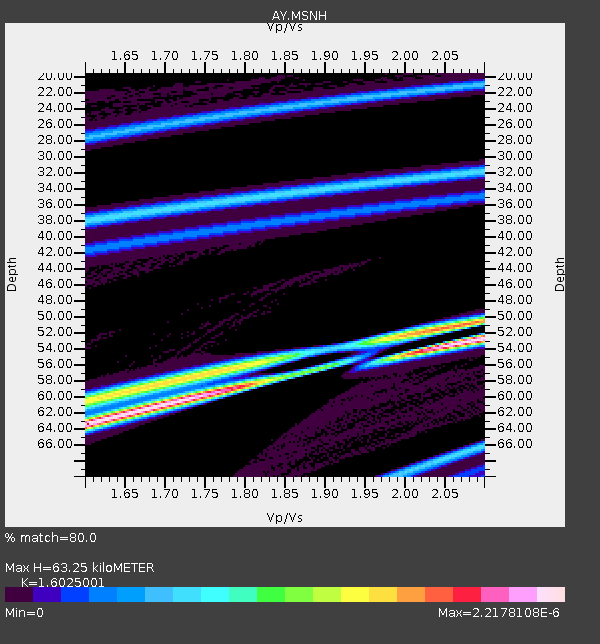
| Crust2 Type: | B7,thick melt affected o.c., 1 km seds. |
| Thickness Estimate: | 63 km |
| Thickness StdDev: | 7.9 km |
| Vp/Vs Estimate: | 1.60 |
| Vp/Vs StdDev: | 0.21 |
| Vs Estimate: | 3.207 km/s |
| Poisson's Ratio: | 0.18 |
| Peak Value: | 0.00 |
| Assumed Vp: | 5.14 km/s |
| Ps Weight: | 0.33333334 |
| PpPs Weight: | 0.33333334 |
| PsPs Weight: | 0.33333328 |
| Residual Complexity: | 0.836 |
| Nearby stations H: | +- |
| (2.0 deg) Vp/Vs: | +- |
21 with match > 90% ( 61.764706 %) and 21 with match > 80% ( 61.764706 %) out of 34.
Download stack as xyz text file.
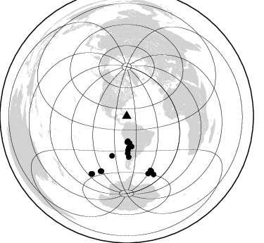
Azimuth Distribution of Events:
Prior Results for this Station
| Study | Thickness | Vp/Vs | Vp | Vs | Poissons Ratio | Extra |
| EARS | 63 km | 1.60 | 5.14 km/s | 3.207 km/s | 0.18 | |
| Crust2.0 | 24 km | 1.98 | 5.14 km/s | 2.6 km/s | 0.33 | B7,thick melt affected o.c., 1 km seds. |
| Global Maxima | 63 km | 1.60 | 5.14 km/s | 3.207 km/s | 0.18 | amp=2.2178108E-6 |
| Local Maxima 1 | 52 km | 2.10 | 5.14 km/s | 2.451 km/s | 0.35 | amp=2.016418E-6 |
| Local Maxima 2 | 52 km | 2.04 | 5.14 km/s | 2.526 km/s | 0.34 | amp=1.6771787E-6 |
| Local Maxima 3 | 61 km | 1.70 | 5.14 km/s | 3.019 km/s | 0.24 | amp=1.5788373E-6 |
| Local Maxima 4 | 56 km | 1.78 | 5.14 km/s | 2.888 km/s | 0.27 | amp=1.0457036E-6 |
| Predicted Arrivals for vertical incidence (zero ray parameter) | |
| Ps | 7.41 SECOND |
| PpPs | 32.02 SECOND |
| PsPs/PpSs | 39.44 SECOND |
Events Processed for this Station
Download zip of receiver functions as SAC
Plot maxima for each earthquake.
Events Used in the Stack
(21 events)| Radial Match | Distance | Baz | FERegion | Time | Lat/Lon | Depth | Magnitude |
| 100.0 | 52.6 deg | 178.539 deg | Near Coast Of Central Chile | 2023/11/06 13:51:10 UTC | (-33.1, -72.0) | 29 km | 5.2 Mww |
| 100.0 | 44.2 deg | 175.615 deg | Near Coast Of Northern Chile | 2023/11/27 10:08:25 UTC | (-24.6, -70.0) | 61 km | 5.0 Mwr |
| 100.0 | 86.3 deg | 205.558 deg | Southern East Pacific Rise | 2024/05/18 23:57:41 UTC | (-55.9, -123.2) | 10 km | 5.9 Mww |
| 99.99999 | 85.0 deg | 155.825 deg | South Sandwich Islands Region | 2024/05/02 06:36:32 UTC | (-55.9, -27.0) | 19 km | 5.4 Mwb |
| 99.999985 | 45.0 deg | 176.345 deg | Near Coast Of Northern Chile | 2023/05/07 06:29:00 UTC | (-25.4, -70.5) | 40 km | 5.2 Mww |
| 99.999985 | 59.8 deg | 200.36 deg | West Chile Rise | 2024/06/04 18:32:56 UTC | (-36.6, -95.3) | 10 km | 5.5 Mwb |
| 99.99998 | 35.4 deg | 177.294 deg | Southern Peru | 2023/06/03 01:49:15 UTC | (-15.7, -71.7) | 10 km | 5.5 Mww |
| 99.99998 | 36.7 deg | 178.968 deg | Near Coast Of Peru | 2024/01/12 13:00:49 UTC | (-17.1, -72.7) | 78 km | 5.3 Mww |
| 99.99998 | 86.9 deg | 159.417 deg | South Sandwich Islands Region | 2024/06/05 10:39:14 UTC | (-59.7, -29.6) | 7.0 km | 5.5 Mww |
| 99.99997 | 85.8 deg | 204.72 deg | Southern East Pacific Rise | 2023/05/08 06:02:16 UTC | (-56.1, -121.4) | 10 km | 5.8 Mww |
| 99.99997 | 84.8 deg | 156.143 deg | South Sandwich Islands Region | 2023/08/20 19:59:48 UTC | (-56.0, -27.6) | 75 km | 5.7 mww |
| 99.99996 | 38.4 deg | 173.757 deg | Northern Chile | 2024/03/13 09:30:05 UTC | (-18.6, -69.3) | 110 km | 5.3 Mww |
| 99.99996 | 85.1 deg | 156.266 deg | South Sandwich Islands Region | 2024/03/20 05:48:21 UTC | (-56.3, -27.4) | 118 km | 5.6 mww |
| 99.999954 | 90.9 deg | 155.108 deg | East Of South Sandwich Islands | 2024/05/07 14:34:58 UTC | (-59.4, -18.0) | 10 km | 5.6 mww |
| 99.99993 | 84.0 deg | 156.182 deg | South Sandwich Islands Region | 2024/01/18 12:46:14 UTC | (-55.4, -28.6) | 23 km | 5.7 mww |
| 99.99991 | 95.9 deg | 211.681 deg | Pacific-Antarctic Ridge | 2024/03/19 18:07:02 UTC | (-56.4, -143.5) | 10 km | 5.5 Mww |
| 99.9999 | 57.8 deg | 177.216 deg | Southern Argentina | 2023/07/17 03:05:10 UTC | (-38.2, -70.4) | 171 km | 6.6 mww |
| 99.99986 | 48.3 deg | 177.896 deg | Near Coast Of Central Chile | 2023/10/31 12:33:44 UTC | (-28.7, -71.6) | 41 km | 6.7 mww |
| 99.999756 | 95.1 deg | 211.077 deg | Pacific-Antarctic Ridge | 2023/03/14 04:24:47 UTC | (-56.6, -141.8) | 10 km | 5.5 Mww |
| 99.99934 | 43.6 deg | 170.854 deg | Jujuy Province, Argentina | 2023/03/22 16:00:31 UTC | (-23.5, -66.5) | 210 km | 6.5 mww |
| 99.998505 | 43.0 deg | 172.926 deg | Northern Chile | 2022/12/10 06:41:28 UTC | (-23.1, -68.1) | 114 km | 5.6 mww |
Losers
(13 events)| Radial Match | Distance | Baz | FERegion | Time | Lat/Lon | Depth | Magnitude | Reason |
| 99.999985 | 70.1 deg | 323.82 deg | Alaska Peninsula | 2023/04/29 16:32:26 UTC | (56.2, -156.7) | 77 km | 6.2 mb | |
| 99.99997 | 45.4 deg | 307.293 deg | Northern California | 2023/05/11 23:19:41 UTC | (40.2, -121.1) | 5.9 km | 5.5 Mw | |
| 99.99996 | 85.5 deg | 324.128 deg | Rat Islands, Aleutian Islands | 2023/06/08 20:31:45 UTC | (52.1, 177.8) | 5.3 km | 5.6 Mww | |
| 99.99996 | 85.2 deg | 323.985 deg | Rat Islands, Aleutian Islands | 2024/03/30 16:28:57 UTC | (52.1, 178.4) | 115 km | 5.8 mww | |
| 99.999954 | 48.8 deg | 306.734 deg | Off Coast Of Northern California | 2023/05/21 18:44:01 UTC | (40.4, -125.5) | 2.1 km | 5.6 Mww | |
| 99.99995 | 68.0 deg | 324.34 deg | Kodiak Island Region, Alaska | 2023/02/21 05:35:23 UTC | (56.8, -153.1) | 9.2 km | 5.4 mww | |
| 99.999794 | 76.7 deg | 285.612 deg | Hawaii | 2024/02/09 20:06:30 UTC | (19.0, -155.5) | 10 km | 6.3 Mi | |
| 99.99966 | 47.1 deg | 108.172 deg | Central Mid-Atlantic Ridge | 2023/01/03 18:19:25 UTC | (0.8, -29.2) | 10 km | 5.5 Mww | |
| 99.99963 | 85.3 deg | 323.498 deg | Rat Islands, Aleutian Islands | 2022/12/14 18:40:26 UTC | (51.6, 178.6) | 73 km | 6.3 Mww | |
| 99.99917 | 73.2 deg | 121.29 deg | Southern Mid-Atlantic Ridge | 2023/02/16 15:55:33 UTC | (-21.9, -11.6) | 10 km | 5.3 Mww | |
| 99.95146 | 93.5 deg | 48.677 deg | Turkey | 2023/02/06 01:26:49 UTC | (37.1, 37.1) | 17 km | 5.6 mb | |
| 99.884995 | 79.1 deg | 321.532 deg | Fox Islands, Aleutian Islands | 2024/05/19 09:35:24 UTC | (52.2, -170.9) | 28 km | 6.0 mww | |
| 99.7707 | 93.5 deg | 48.569 deg | Turkey | 2023/02/06 01:28:13 UTC | (37.1, 37.2) | 12 km | 6.7 Mww |

