
Station BK BDM - Black Diamond Mines Park, Antioch, CA
Network: BK - Berkeley Digital Seismograph Network
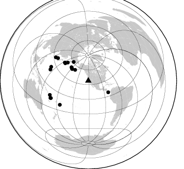
Nearby stations (2 deg radius)
| Station | Name | (Lat, Lon) | Start / End | Elevation |
| BDM | Black Diamond Mines Park, Antioch, CA | (37.95, -121.87) | 1998-11-12 / 2499-01-01 | 220 m |
| Crust2 Type: | T4,Margin /shield transition, East Siberia, 2 km seds. |
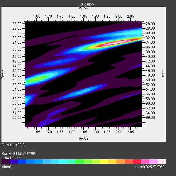
| Thickness Estimate: | 34 km |
| Thickness StdDev: | 5.1 km |
| Vp/Vs Estimate: | 1.99 |
| Vp/Vs StdDev: | 0.12 |
| Vs Estimate: | 3.215 km/s |
| Poisson's Ratio: | 0.33 |
| Peak Value: | 0.03 |
| Assumed Vp: | 6.391 km/s |
| Ps Weight: | 0.33333334 |
| PpPs Weight: | 0.33333334 |
| PsPs Weight: | 0.33333328 |
| Residual Complexity: | 0.510 |
| Nearby stations H: | +- |
| (2.0 deg) Vp/Vs: | +- |
4 with match > 90% ( 20.0 %) and 18 with match > 80% ( 90.0 %) out of 20.
Download stack as xyz text file.
Azimuth Distribution of Events:
Prior Results for this Station
| Study | Thickness | Vp/Vs | Vp | Vs | Poissons Ratio | Extra |
| EARS | 34 km | 1.99 | 6.391 km/s | 3.215 km/s | 0.33 | |
| Crust2.0 | 32 km | 1.79 | 6.391 km/s | 3.572 km/s | 0.27 | T4,Margin /shield transition, East Siberia, 2 km seds. |
| Global Maxima | 34 km | 1.99 | 6.391 km/s | 3.215 km/s | 0.33 | amp=0.025272762 |
| Local Maxima 1 | 50 km | 1.64 | 6.391 km/s | 3.885 km/s | 0.21 | amp=0.013304252 |
| Local Maxima 2 | 58 km | 1.60 | 6.391 km/s | 3.994 km/s | 0.18 | amp=0.008415877 |
| Local Maxima 3 | 55 km | 1.85 | 6.391 km/s | 3.459 km/s | 0.29 | amp=0.0073888027 |
| Local Maxima 4 | 32 km | 2.05 | 6.391 km/s | 3.117 km/s | 0.34 | amp=0.0072345044 |
| Predicted Arrivals for vertical incidence (zero ray parameter) | |
| Ps | 5.25 SECOND |
| PpPs | 15.89 SECOND |
| PsPs/PpSs | 21.15 SECOND |
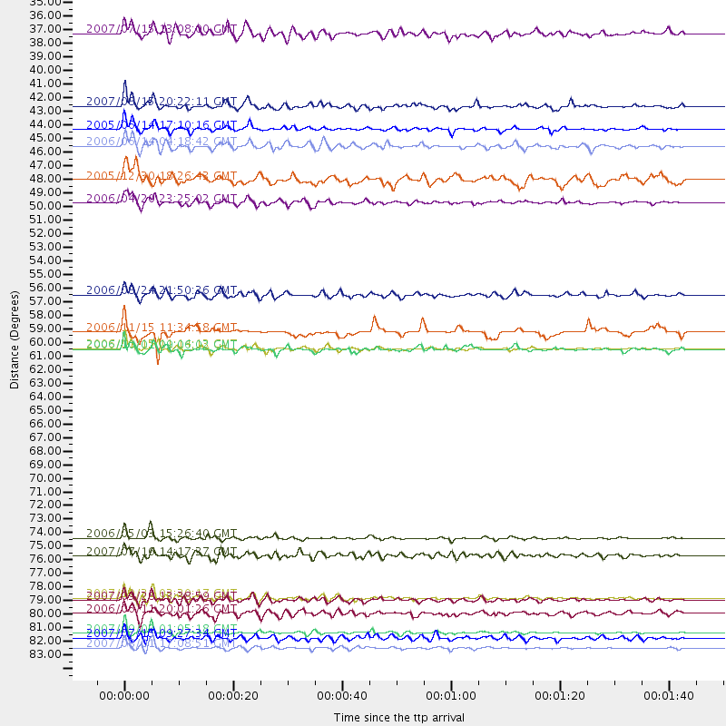
Events Processed for this Station
Download zip of receiver functions as SAC
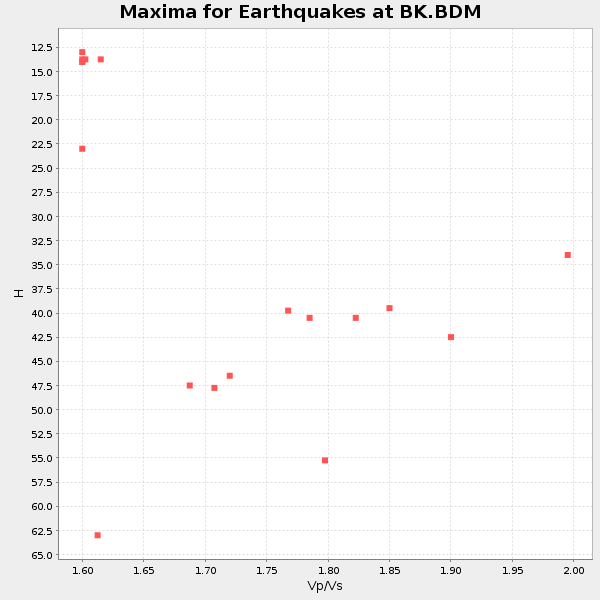
Plot maxima for each earthquake.
Events Used in the Stack
(18 events)| Radial Match | Distance | Baz | FERegion | Time | Lat/Lon | Depth | Magnitude |
| 94.2852 | 83.6 deg | 250.005 deg | Santa Cruz Islands | 2007/09/02 01:05:18 GMT | (-11.6, 165.8) | 35 km | 5.9 MB, 7.3 MS, 7.2 MW, 6.9 ME |
| 94.089516 | 75.9 deg | 229.997 deg | Tonga Islands | 2006/05/03 15:26:40 GMT | (-20.2, -174.1) | 55 km | 7.2 MB, 7.8 MS, 7.9 MW, 7.9 MW |
| 93.65296 | 60.5 deg | 307.899 deg | Kuril Islands | 2006/11/15 11:14:13 GMT | (46.6, 153.3) | 10 km | 6.5 MB, 7.8 MS, 8.3 MW, 7.9 MW |
| 90.862236 | 84.8 deg | 245.773 deg | Vanuatu Islands | 2007/08/01 17:08:51 GMT | (-15.6, 167.7) | 120 km | 6.2 MB, 7.2 MW, 7.2 MW |
| 89.97629 | 48.7 deg | 322.094 deg | Eastern Siberia, Russia | 2006/04/20 23:25:02 GMT | (60.9, 167.1) | 22 km | 6.8 MB, 7.6 MS, 7.6 MW, 7.3 MW |
| 89.63951 | 46.9 deg | 120.008 deg | South Of Panama | 2005/12/30 18:26:43 GMT | (7.5, -82.3) | 10 km | 5.8 MB, 5.4 MS, 6.1 MW, 6.1 MW |
| 89.54217 | 42.8 deg | 307.666 deg | Rat Islands, Aleutian Islands | 2005/06/14 17:10:16 GMT | (51.2, 179.4) | 51 km | 6.0 MB, 6.8 MW, 6.6 MW |
| 88.65159 | 59.2 deg | 307.284 deg | East Of Kuril Islands | 2006/11/15 11:34:58 GMT | (46.7, 155.3) | 10 km | 6.4 MB |
| 86.61527 | 80.9 deg | 290.685 deg | Volcano Islands, Japan Region | 2007/09/28 13:38:59 GMT | (22.0, 142.7) | 276 km | 6.7 MB, 7.4 MW, 7.4 MW |
| 85.97228 | 40.9 deg | 306.053 deg | Andreanof Islands, Aleutian Is. | 2007/08/15 20:22:11 GMT | (50.3, -177.5) | 9.0 km | 6.3 MB, 6.2 MS, 6.4 MW, 5.9 ML |
| 84.94007 | 56.2 deg | 311.566 deg | Near East Coast Of Kamchatka | 2006/08/24 21:50:36 GMT | (51.1, 157.5) | 43 km | 5.9 MB, 6.2 MS, 6.5 MW, 6.5 MW |
| 84.347115 | 84.0 deg | 245.339 deg | Vanuatu Islands | 2007/07/15 09:27:34 GMT | (-15.4, 168.6) | 8.0 km | 6.0 MB, 5.8 MS, 6.1 MW, 6.0 MW |
| 84.08085 | 80.7 deg | 286.633 deg | Mariana Islands | 2007/10/31 03:30:17 GMT | (18.9, 145.4) | 223 km | 6.2 MB, 7.2 MW, 7.2 MW |
| 83.92014 | 44.1 deg | 308.645 deg | Rat Islands, Aleutian Islands | 2006/06/14 04:18:42 GMT | (51.8, 177.1) | 14 km | 5.9 MB, 6.4 MS, 6.4 MW, 6.4 MW |
| 82.58625 | 82.0 deg | 305.867 deg | Kyushu, Japan | 2006/06/11 20:01:26 GMT | (33.1, 131.1) | 140 km | 5.9 MB, 6.3 MW, 6.3 MW |
| 82.27665 | 35.0 deg | 309.674 deg | Fox Islands, Aleutian Islands | 2007/07/15 13:08:00 GMT | (52.5, -168.0) | 10 km | 5.8 MB, 5.9 MS, 6.1 MW, 6.0 MW |
| 80.25042 | 77.3 deg | 306.809 deg | Sea Of Japan | 2007/07/16 14:17:37 GMT | (36.8, 134.9) | 350 km | 6.2 MB, 6.8 MW, 6.8 MW |
| 80.20074 | 60.6 deg | 307.781 deg | Kuril Islands | 2006/10/01 09:06:02 GMT | (46.5, 153.2) | 19 km | 6.1 MB, 6.4 MS, 6.6 MW, 6.5 MW |
Losers
(2 events)| Radial Match | Distance | Baz | FERegion | Time | Lat/Lon | Depth | Magnitude | Reason |
| 87.33038 | 41.5 deg | 120.326 deg | Near Coast Of Nicaragua | 2005/07/02 02:16:43 GMT | (11.2, -86.2) | 27 km | 5.6 MB, 6.4 MS, 6.6 MW, 6.6 MW | |
| 47.990803 | 41.4 deg | 120.241 deg | Near Coast Of Nicaragua | 2005/07/02 04:11:04 GMT | (11.4, -86.3) | 40 km | 5.4 MB, 5.4 MS, 5.8 MW, 5.0 MD |
