
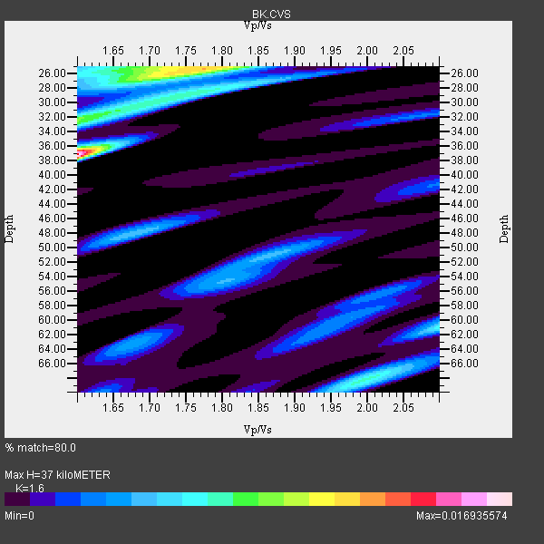
Station BK CVS - Carmenet Vineyards, Sonoma, CA
Network: BK - Berkeley Digital Seismograph Network
Nearby stations (2 deg radius)
| Station | Name | (Lat, Lon) | Start / End | Elevation |
| CVS | Carmenet Vineyards, Sonoma, CA | (38.35, -122.46) | 1998-05-06 / 2499-01-01 | 295 m |
| Crust2 Type: | T6,Margin /shield transition, 1 km seds. |
| Thickness Estimate: | 37 km |
| Thickness StdDev: | 4.3 km |
| Vp/Vs Estimate: | 1.60 |
| Vp/Vs StdDev: | 0.06 |
| Vs Estimate: | 4.045 km/s |
| Poisson's Ratio: | 0.18 |
| Peak Value: | 0.02 |
| Assumed Vp: | 6.472 km/s |
| Ps Weight: | 0.33333334 |
| PpPs Weight: | 0.33333334 |
| PsPs Weight: | 0.33333328 |
| Residual Complexity: | 0.922 |
| Nearby stations H: | +- |
| (2.0 deg) Vp/Vs: | +- |
22 with match > 90% ( 36.065575 %) and 59 with match > 80% ( 96.72131 %) out of 61.
Download stack as xyz text file.
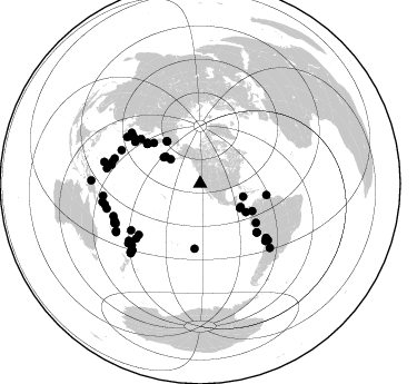
Azimuth Distribution of Events:
Prior Results for this Station
| Study | Thickness | Vp/Vs | Vp | Vs | Poissons Ratio | Extra |
| EARS | 37 km | 1.60 | 6.472 km/s | 4.045 km/s | 0.18 | |
| Crust2.0 | 32 km | 1.79 | 6.472 km/s | 3.622 km/s | 0.27 | T6,Margin /shield transition, 1 km seds. |
| Global Maxima | 37 km | 1.60 | 6.472 km/s | 4.045 km/s | 0.18 | amp=0.016935574 |
| Local Maxima 1 | 26 km | 1.76 | 6.472 km/s | 3.682 km/s | 0.26 | amp=0.011434374 |
| Local Maxima 2 | 32 km | 1.60 | 6.472 km/s | 4.045 km/s | 0.18 | amp=0.008013779 |
| Local Maxima 3 | 68 km | 2.00 | 6.472 km/s | 3.236 km/s | 0.33 | amp=0.006849691 |
| Local Maxima 4 | 25 km | 1.70 | 6.472 km/s | 3.807 km/s | 0.24 | amp=0.00617276 |
| Predicted Arrivals for vertical incidence (zero ray parameter) | |
| Ps | 3.43 SECOND |
| PpPs | 14.86 SECOND |
| PsPs/PpSs | 18.29 SECOND |
Events Processed for this Station
Download zip of receiver functions as SAC
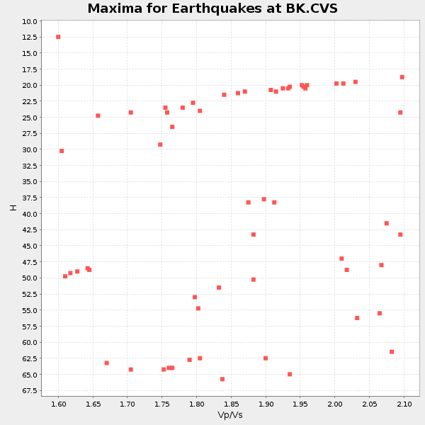
Plot maxima for each earthquake.
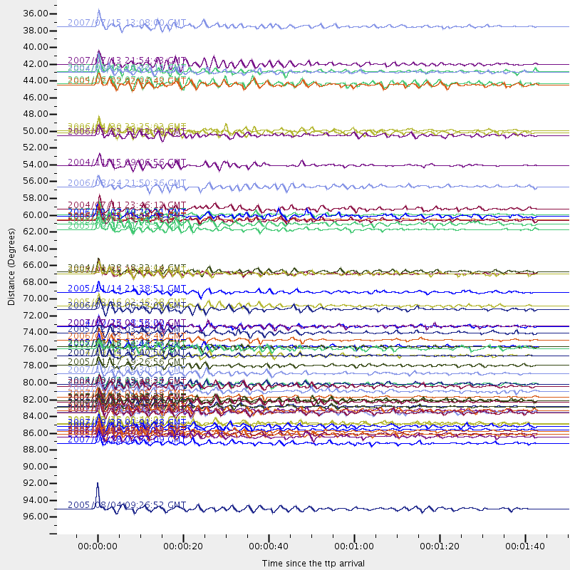
Events Used in the Stack
(59 events)| Radial Match | Distance | Baz | FERegion | Time | Lat/Lon | Depth | Magnitude |
| 97.004135 | 59.9 deg | 307.521 deg | Kuril Islands | 2006/11/15 11:14:13 GMT | (46.6, 153.3) | 10 km | 6.5 MB, 7.8 MS, 8.3 MW, 7.9 MW |
| 96.4177 | 76.6 deg | 129.203 deg | Northern Chile | 2005/06/13 22:44:33 GMT | (-20.0, -69.2) | 116 km | 6.8 MB, 7.8 MW, 7.8 MW |
| 96.109436 | 87.8 deg | 257.527 deg | Solomon Islands | 2007/04/01 20:39:56 GMT | (-8.5, 157.0) | 10 km | 6.8 MB, 7.9 MS, 8.1 MW, 7.7 ME |
| 95.86177 | 77.9 deg | 131.194 deg | Northern Chile | 2007/11/14 15:40:50 GMT | (-22.2, -69.9) | 40 km | 6.7 MB, 7.4 MS, 7.7 MW, 7.4 ME |
| 95.56956 | 83.3 deg | 249.579 deg | Santa Cruz Islands | 2007/09/02 01:05:18 GMT | (-11.6, 165.8) | 35 km | 5.9 MB, 7.3 MS, 7.2 MW, 6.9 ME |
| 95.372025 | 75.7 deg | 229.481 deg | Tonga Islands | 2006/05/03 15:26:40 GMT | (-20.2, -174.1) | 55 km | 7.2 MB, 7.8 MS, 7.9 MW, 7.9 MW |
| 95.051 | 48.1 deg | 321.843 deg | Eastern Siberia, Russia | 2006/04/20 23:25:02 GMT | (60.9, 167.1) | 22 km | 6.8 MB, 7.6 MS, 7.6 MW, 7.3 MW |
| 95.03364 | 59.3 deg | 306.727 deg | East Of Kuril Islands | 2007/01/13 04:23:21 GMT | (46.2, 154.5) | 10 km | 7.3 MB, 8.2 MS, 8.1 MW, 7.9 MW |
| 94.44777 | 87.6 deg | 225.539 deg | Kermadec Islands Region | 2006/05/16 10:39:23 GMT | (-31.8, -179.3) | 152 km | 6.8 MB, 7.4 MW, 7.4 MW |
| 94.008064 | 77.9 deg | 302.505 deg | Near S. Coast Of Western Honshu | 2004/09/05 10:07:07 GMT | (33.1, 136.6) | 14 km | 6.7 MB, 7.0 MS, 7.2 MW, 7.0 MW |
| 93.551956 | 61.2 deg | 125.116 deg | Northern Peru | 2005/09/26 01:55:37 GMT | (-5.7, -76.4) | 115 km | 6.7 MB, 7.5 MW, 7.5 MW |
| 93.3317 | 84.5 deg | 245.356 deg | Vanuatu Islands | 2007/08/01 17:08:51 GMT | (-15.6, 167.7) | 120 km | 6.2 MB, 7.2 MW, 7.2 MW |
| 92.96199 | 71.7 deg | 230.24 deg | Samoa Islands Region | 2006/09/28 06:22:09 GMT | (-16.6, -172.0) | 28 km | 6.5 MB, 6.6 MS, 6.9 MW, 6.7 MW |
| 92.4096 | 74.0 deg | 305.246 deg | Near West Coast Of Honshu, Japan | 2007/07/16 01:13:22 GMT | (37.5, 138.4) | 12 km | 6.5 MB, 6.4 MS, 6.6 MW, 6.5 MW |
| 92.36329 | 34.4 deg | 309.303 deg | Fox Islands, Aleutian Islands | 2007/07/15 13:08:00 GMT | (52.5, -168.0) | 10 km | 5.8 MB, 5.9 MS, 6.1 MW, 6.0 MW |
| 92.30419 | 67.0 deg | 130.652 deg | Near Coast Of Peru | 2007/08/15 23:40:57 GMT | (-13.4, -76.6) | 39 km | 6.7 MB, 7.9 MS, 8.0 MW, 7.5 ME |
| 91.91448 | 85.0 deg | 279.305 deg | South Of Mariana Islands | 2007/09/30 02:08:30 GMT | (10.5, 145.7) | 14 km | 6.4 MB, 7.1 MS, 6.9 MW, 6.9 MW |
| 91.64973 | 52.8 deg | 117.839 deg | Near West Coast Of Colombia | 2004/11/15 09:06:56 GMT | (4.7, -77.5) | 15 km | 6.6 MB, 7.1 MS, 7.2 MW, 7.1 MW |
| 91.61061 | 84.5 deg | 245.144 deg | Vanuatu Islands | 2006/08/07 22:18:54 GMT | (-15.8, 167.8) | 141 km | 6.0 MB, 6.8 MW, 6.8 MW |
| 91.44993 | 86.8 deg | 254.955 deg | Solomon Islands | 2007/08/16 08:39:27 GMT | (-9.8, 159.5) | 10 km | 6.1 MB, 6.7 MS, 6.4 MW |
| 91.33493 | 71.2 deg | 304.164 deg | Near East Coast Of Honshu, Japan | 2005/08/16 02:46:28 GMT | (38.3, 142.0) | 36 km | 6.5 MB, 6.8 MS, 7.2 MW, 7.1 MW |
| 90.92882 | 88.2 deg | 225.032 deg | South Of Kermadec Islands | 2005/05/16 03:54:14 GMT | (-32.6, -179.4) | 34 km | 6.2 MB, 6.4 MS, 6.6 MW, 6.6 MW |
| 89.6475 | 83.8 deg | 230.288 deg | South Of Fiji Islands | 2007/10/16 21:05:43 GMT | (-25.8, 179.5) | 509 km | 6.2 MB, 6.6 MW, 6.5 MW |
| 89.54834 | 69.4 deg | 302.691 deg | Off East Coast Of Honshu, Japan | 2005/11/14 21:38:51 GMT | (38.1, 144.9) | 11 km | 6.7 MB, 6.8 MS, 7.0 MW, 6.9 MW |
| 88.95966 | 88.1 deg | 262.788 deg | New Ireland Region, P.N.G. | 2005/09/09 07:26:43 GMT | (-4.5, 153.5) | 90 km | 6.3 MB, 7.7 MW, 7.5 MW |
| 88.95156 | 89.4 deg | 259.408 deg | Solomon Islands | 2007/06/28 02:52:09 GMT | (-8.0, 154.6) | 10 km | 6.3 MB, 6.7 MS, 6.7 MW, 6.7 MW |
| 88.788345 | 81.5 deg | 283.619 deg | Mariana Islands | 2005/02/05 03:34:25 GMT | (16.0, 145.9) | 143 km | 6.3 MB, 6.6 MW, 6.5 MW |
| 88.75205 | 41.9 deg | 121.52 deg | Off Coast Of Costa Rica | 2004/06/29 07:01:30 GMT | (10.7, -87.0) | 9.0 km | 5.8 MB, 5.8 MS, 6.3 MW, 6.1 MW |
| 88.27996 | 83.7 deg | 244.915 deg | Vanuatu Islands | 2007/07/15 09:27:34 GMT | (-15.4, 168.6) | 8.0 km | 6.0 MB, 5.8 MS, 6.1 MW, 6.0 MW |
| 87.87095 | 60.0 deg | 307.402 deg | Kuril Islands | 2006/10/01 09:06:02 GMT | (46.5, 153.2) | 19 km | 6.1 MB, 6.4 MS, 6.6 MW, 6.5 MW |
| 87.60962 | 73.9 deg | 304.824 deg | Near West Coast Of Honshu, Japan | 2004/10/23 08:56:00 GMT | (37.2, 138.8) | 16 km | 6.4 MB, 6.3 MS, 6.6 MW, 6.4 MW |
| 87.17297 | 58.4 deg | 184.926 deg | South Pacific Ocean | 2004/07/11 23:46:12 GMT | (-20.3, -126.9) | 12 km | 6.1 MB, 5.9 MS, 6.1 MW, 6.1 MW |
| 87.14986 | 87.1 deg | 240.154 deg | Southeast Of Loyalty Islands | 2007/09/28 01:01:48 GMT | (-21.2, 169.4) | 10 km | 5.8 MB, 6.4 MS, 6.3 MW, 6.2 MW |
| 86.90538 | 66.7 deg | 307.063 deg | Hokkaido, Japan Region | 2004/11/28 18:32:14 GMT | (43.0, 145.1) | 39 km | 6.4 MB, 6.7 MS, 7.0 MW, 7.0 MW |
| 86.86899 | 98.0 deg | 271.69 deg | Irian Jaya, Indonesia | 2005/08/04 09:26:52 GMT | (-3.7, 140.2) | 40 km | 5.7 MB, 5.6 MS, 5.8 MW, 5.8 MW |
| 86.793594 | 85.3 deg | 225.994 deg | Kermadec Islands, New Zealand | 2007/01/31 03:15:52 GMT | (-29.8, -178.0) | 34 km | 6.1 MB, 6.3 MS, 6.5 MW, 6.4 MW |
| 86.35649 | 81.9 deg | 231.42 deg | South Of Fiji Islands | 2006/02/26 03:08:27 GMT | (-23.6, -180.0) | 535 km | 5.9 MB, 6.4 MW, 6.4 MW |
| 85.93569 | 81.6 deg | 281.782 deg | Mariana Islands | 2004/10/04 19:20:34 GMT | (14.5, 147.0) | 7.2 km | 5.9 MB, 5.9 MS, 6.0 MW, 5.9 MW |
| 85.761246 | 40.3 deg | 305.638 deg | Andreanof Islands, Aleutian Is. | 2007/08/15 20:22:11 GMT | (50.3, -177.5) | 9.0 km | 6.3 MB, 6.2 MS, 6.4 MW, 5.9 ML |
| 85.19318 | 86.7 deg | 240.585 deg | Vanuatu Islands | 2007/03/25 00:40:01 GMT | (-20.6, 169.4) | 34 km | 6.5 MB, 7.0 MS, 7.1 MW, 7.1 MW |
| 85.08345 | 80.2 deg | 286.228 deg | Mariana Islands | 2007/10/31 03:30:17 GMT | (18.9, 145.4) | 223 km | 6.2 MB, 7.2 MW, 7.2 MW |
| 84.916336 | 76.7 deg | 306.436 deg | Sea Of Japan | 2007/07/16 14:17:37 GMT | (36.8, 134.9) | 350 km | 6.2 MB, 6.8 MW, 6.8 MW |
| 84.74849 | 48.8 deg | 321.699 deg | Eastern Siberia, Russia | 2006/05/22 11:12:00 GMT | (60.8, 165.7) | 16 km | 6.0 MB, 6.7 MS, 6.6 MW, 6.5 MW |
| 84.73387 | 59.4 deg | 306.679 deg | East Of Kuril Islands | 2006/12/07 19:10:21 GMT | (46.2, 154.4) | 16 km | 6.3 MB, 6.1 MS, 6.3 MW, 6.3 MW |
| 84.336555 | 39.4 deg | 307.935 deg | Andreanof Islands, Aleutian Is. | 2007/07/13 21:54:43 GMT | (51.8, -176.3) | 35 km | 5.7 MB, 5.6 MS, 6.0 MW, 5.9 MW |
| 83.95072 | 83.9 deg | 246.627 deg | Vanuatu Islands | 2005/02/08 14:48:21 GMT | (-14.3, 167.3) | 206 km | 6.1 MB, 6.8 MW, 6.7 MW |
| 83.50764 | 88.5 deg | 282.653 deg | W. Caroline Islands, Micronesia | 2005/01/16 20:17:52 GMT | (10.9, 140.8) | 25 km | 6.3 MB, 6.7 MS, 6.6 MW, 6.6 MW |
| 83.36708 | 79.1 deg | 129.795 deg | Chile-Bolivia Border Region | 2005/11/17 19:26:56 GMT | (-22.3, -67.9) | 163 km | 6.0 MB, 6.9 MW, 6.8 MW |
| 83.27715 | 42.1 deg | 120.075 deg | Near Coast Of Nicaragua | 2005/07/02 02:16:43 GMT | (11.2, -86.2) | 27 km | 5.6 MB, 6.4 MS, 6.6 MW, 6.6 MW |
| 83.199295 | 82.5 deg | 228.087 deg | South Of Fiji Islands | 2007/07/18 00:07:35 GMT | (-26.3, -177.7) | 10 km | 5.8 MB, 5.9 MS, 6.1 MW, 6.0 MW |
| 82.96731 | 55.5 deg | 311.212 deg | Near East Coast Of Kamchatka | 2006/08/24 21:50:36 GMT | (51.1, 157.5) | 43 km | 5.9 MB, 6.2 MS, 6.5 MW, 6.5 MW |
| 82.875854 | 40.5 deg | 106.749 deg | Caribbean Sea | 2004/12/14 23:20:13 GMT | (19.0, -81.4) | 10 km | 6.2 MB, 6.7 MS, 6.8 MW, 6.8 MW |
| 82.81733 | 74.8 deg | 236.109 deg | Fiji Islands Region | 2005/12/13 03:16:06 GMT | (-15.3, -178.6) | 10 km | 6.1 MB, 6.8 MS, 6.7 MW, 6.7 MW |
| 82.616974 | 67.0 deg | 130.761 deg | Near Coast Of Peru | 2006/10/20 10:48:56 GMT | (-13.5, -76.7) | 23 km | 5.9 MB, 6.6 MS, 6.7 MW, 6.6 MW |
| 82.23735 | 85.0 deg | 132.505 deg | Santiago Del Estero Prov., Arg. | 2004/09/07 11:53:06 GMT | (-28.6, -65.8) | 22 km | 6.1 MB, 6.1 MS, 6.4 MW, 6.2 MW |
| 81.999954 | 60.4 deg | 99.904 deg | Trinidad | 2006/09/29 13:08:26 GMT | (10.9, -61.8) | 53 km | 5.9 MB, 5.4 MS, 6.1 MW, 6.0 MW |
| 81.632286 | 85.3 deg | 225.599 deg | Kermadec Islands, New Zealand | 2005/12/07 23:32:51 GMT | (-30.0, -177.6) | 21 km | 6.0 MB, 6.4 MS, 6.4 MW, 6.3 MW |
| 81.028496 | 76.9 deg | 292.872 deg | Bonin Islands, Japan Region | 2006/08/06 18:16:40 GMT | (26.1, 144.0) | 23 km | 6.0 MB, 5.6 MS, 5.8 MW, 5.8 MW |
| 80.99086 | 48.4 deg | 121.944 deg | South Of Panama | 2005/05/05 19:12:20 GMT | (5.7, -82.8) | 10 km | 5.9 MB, 5.8 MS, 6.5 MW, 6.4 MW |
Losers
(2 events)| Radial Match | Distance | Baz | FERegion | Time | Lat/Lon | Depth | Magnitude | Reason |
| 91.11307 | 76.6 deg | 234.503 deg | Fiji Islands Region | 2004/07/15 04:27:12 GMT | (-17.6, -178.6) | 560 km | 5.5 MB | |
| 56.637177 | 42.0 deg | 119.993 deg | Near Coast Of Nicaragua | 2005/07/02 04:11:04 GMT | (11.4, -86.3) | 40 km | 5.4 MB, 5.4 MS, 5.8 MW, 5.0 MD |
