
Station BK JRSC - Jasper Ridge Biological Preserve, Stanford, CA
Network: BK - Berkeley Digital Seismograph Network
Nearby stations (2 deg radius)
| Station | Name | (Lat, Lon) | Start / End | Elevation |
| JRSC | Jasper Ridge Biological Preserve, Stanford, CA | (37.40, -122.24) | 1994-06-30 / 2499-01-01 | 70 m |
| Crust2 Type: | S1,continental slope, margin, transition 1 km seds. |
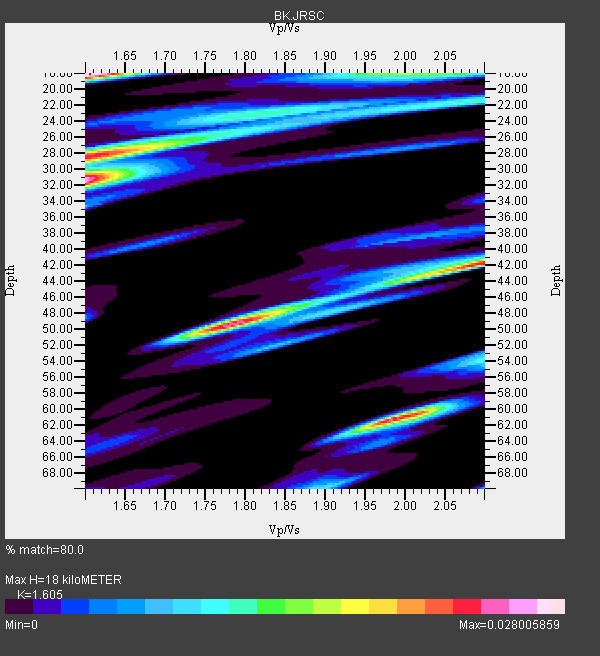
| Thickness Estimate: | 18 km |
| Thickness StdDev: | 8.7 km |
| Vp/Vs Estimate: | 1.61 |
| Vp/Vs StdDev: | 0.09 |
| Vs Estimate: | 3.852 km/s |
| Poisson's Ratio: | 0.18 |
| Peak Value: | 0.03 |
| Assumed Vp: | 6.183 km/s |
| Ps Weight: | 0.33333334 |
| PpPs Weight: | 0.33333334 |
| PsPs Weight: | 0.33333328 |
| Residual Complexity: | 0.959 |
| Nearby stations H: | +- |
| (2.0 deg) Vp/Vs: | +- |
2 with match > 90% ( 40.0 %) and 4 with match > 80% ( 80.0 %) out of 5.
Download stack as xyz text file.
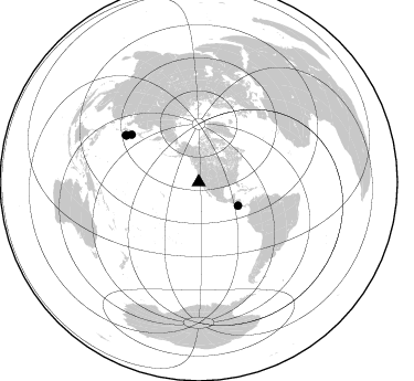
Azimuth Distribution of Events:
Prior Results for this Station
| Study | Thickness | Vp/Vs | Vp | Vs | Poissons Ratio | Extra |
| EARS | 18 km | 1.61 | 6.183 km/s | 3.852 km/s | 0.18 | |
| Crust2.0 | 23 km | 1.81 | 6.183 km/s | 3.422 km/s | 0.28 | S1,continental slope, margin, transition 1 km seds. |
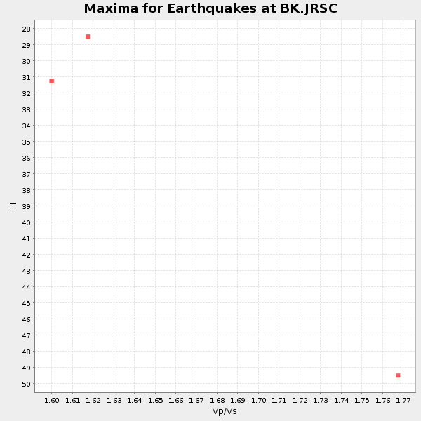
| Global Maxima | 18 km | 1.61 | 6.183 km/s | 3.852 km/s | 0.18 | amp=0.028005859 |
| Local Maxima 1 | 31 km | 1.60 | 6.183 km/s | 3.864 km/s | 0.18 | amp=0.026346423 |
| Local Maxima 2 | 49 km | 1.79 | 6.183 km/s | 3.464 km/s | 0.27 | amp=0.024644924 |
| Local Maxima 3 | 61 km | 1.99 | 6.183 km/s | 3.107 km/s | 0.33 | amp=0.023911886 |
| Local Maxima 4 | 42 km | 2.09 | 6.183 km/s | 2.955 km/s | 0.35 | amp=0.021795414 |
| Predicted Arrivals for vertical incidence (zero ray parameter) | |
| Ps | 1.76 SECOND |
| PpPs | 7.58 SECOND |
| PsPs/PpSs | 9.35 SECOND |
Events Processed for this Station
Download zip of receiver functions as SAC
Plot maxima for each earthquake.
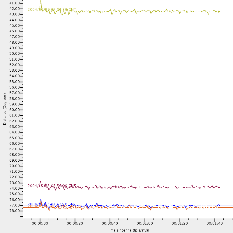
Events Used in the Stack
(4 events)| Radial Match | Distance | Baz | FERegion | Time | Lat/Lon | Depth | Magnitude |
| 96.10512 | 78.1 deg | 302.645 deg | Near S. Coast Of Honshu, Japan | 2004/09/05 14:57:18 GMT | (33.2, 137.1) | 10 km | 6.2 MB, 7.1 MS, 7.4 MW, 7.4 MW |
| 95.46714 | 78.5 deg | 302.786 deg | Near S. Coast Of Western Honshu | 2004/09/05 10:07:07 GMT | (33.1, 136.6) | 14 km | 6.7 MB, 7.0 MS, 7.2 MW, 7.0 MW |
| 86.079994 | 41.3 deg | 120.85 deg | Off Coast Of Costa Rica | 2004/06/29 07:01:30 GMT | (10.7, -87.0) | 9.0 km | 5.8 MB, 5.8 MS, 6.3 MW, 6.1 MW |
| 82.11191 | 74.6 deg | 305.147 deg | Near West Coast Of Honshu, Japan | 2004/10/23 08:56:00 GMT | (37.2, 138.8) | 16 km | 6.4 MB, 6.3 MS, 6.6 MW, 6.4 MW |
Losers
(1 events)| Radial Match | Distance | Baz | FERegion | Time | Lat/Lon | Depth | Magnitude | Reason |
| 93.68619 | 76.2 deg | 234.847 deg | Fiji Islands Region | 2004/07/15 04:27:12 GMT | (-17.6, -178.6) | 560 km | 5.5 MB |
