
Station BK WENL - Wente Vineyards, Livermore, CA
Network: BK - Berkeley Digital Seismograph Network
Nearby stations (2 deg radius)
| Station | Name | (Lat, Lon) | Start / End | Elevation |
| WENL | Wente Vineyards, Livermore, CA | (37.62, -121.76) | 1998-07-15 / 2499-01-01 | 139 m |
| Crust2 Type: | T4,Margin /shield transition, East Siberia, 2 km seds. |
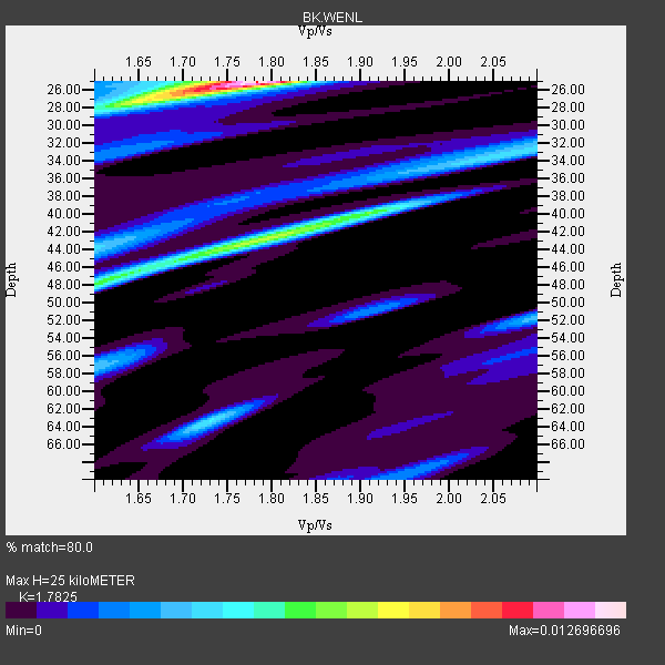
| Thickness Estimate: | 25 km |
| Thickness StdDev: | 5.6 km |
| Vp/Vs Estimate: | 1.78 |
| Vp/Vs StdDev: | 0.04 |
| Vs Estimate: | 3.585 km/s |
| Poisson's Ratio: | 0.27 |
| Peak Value: | 0.01 |
| Assumed Vp: | 6.391 km/s |
| Ps Weight: | 0.33333334 |
| PpPs Weight: | 0.33333334 |
| PsPs Weight: | 0.33333328 |
| Residual Complexity: | 0.713 |
| Nearby stations H: | +- |
| (2.0 deg) Vp/Vs: | +- |
15 with match > 90% ( 50.0 %) and 29 with match > 80% ( 96.666664 %) out of 30.
Download stack as xyz text file.
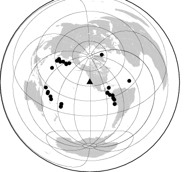
Azimuth Distribution of Events:
Prior Results for this Station
| Study | Thickness | Vp/Vs | Vp | Vs | Poissons Ratio | Extra |
| EARS | 25 km | 1.78 | 6.391 km/s | 3.585 km/s | 0.27 | |
| Crust2.0 | 32 km | 1.79 | 6.391 km/s | 3.572 km/s | 0.27 | T4,Margin /shield transition, East Siberia, 2 km seds. |
| Global Maxima | 25 km | 1.78 | 6.391 km/s | 3.585 km/s | 0.27 | amp=0.012696696 |
| Local Maxima 1 | 43 km | 1.79 | 6.391 km/s | 3.57 km/s | 0.27 | amp=0.007187337 |
| Local Maxima 2 | 48 km | 1.61 | 6.391 km/s | 3.969 km/s | 0.19 | amp=0.005659786 |
| Local Maxima 3 | 40 km | 1.91 | 6.391 km/s | 3.35 km/s | 0.31 | amp=0.004992288 |
| Local Maxima 4 | 63 km | 1.73 | 6.391 km/s | 3.689 km/s | 0.25 | amp=0.0044809873 |
| Predicted Arrivals for vertical incidence (zero ray parameter) | |
| Ps | 3.06 SECOND |
| PpPs | 10.89 SECOND |
| PsPs/PpSs | 13.95 SECOND |
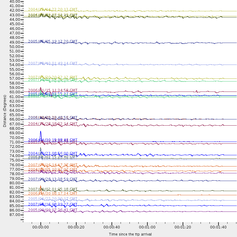
Events Processed for this Station
Download zip of receiver functions as SAC
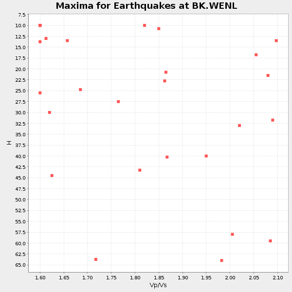
Plot maxima for each earthquake.
Events Used in the Stack
(29 events)| Radial Match | Distance | Baz | FERegion | Time | Lat/Lon | Depth | Magnitude |
| 99.79551 | 84.6 deg | 246.392 deg | Vanuatu Islands | 2006/04/30 08:17:34 GMT | (-15.1, 167.4) | 128 km | 5.4 MB, 6.1 MW, 6.1 MW |
| 99.71802 | 71.6 deg | 232.677 deg | Tonga Islands | 2006/04/30 15:08:41 GMT | (-15.4, -173.2) | 10 km | 5.4 MB, 5.1 MS, 5.5 MW, 5.5 MW |
| 99.717735 | 75.7 deg | 230.142 deg | Tonga Islands | 2006/05/03 15:26:40 GMT | (-20.2, -174.1) | 55 km | 7.2 MB, 7.8 MS, 7.9 MW, 7.9 MW |
| 99.69855 | 71.6 deg | 232.52 deg | Tonga Islands | 2006/04/30 19:33:18 GMT | (-15.5, -173.1) | 10 km | 5.8 MB, 5.9 MS, 5.9 MW |
| 99.68223 | 76.0 deg | 229.817 deg | Tonga Islands | 2006/05/04 11:25:26 GMT | (-20.6, -174.0) | 11 km | 5.7 MB, 5.8 MS, 6.0 MW, 5.8 MW |
| 97.69728 | 60.8 deg | 308.082 deg | Kuril Islands | 2006/11/15 11:14:13 GMT | (46.6, 153.3) | 10 km | 6.5 MB, 7.8 MS, 8.3 MW, 7.9 MW |
| 97.38012 | 60.5 deg | 23.562 deg | Jan Mayen Island Region | 2005/07/06 08:24:41 GMT | (69.0, -16.6) | 10 km | 5.1 MB, 5.2 MS, 5.6 MW, 5.5 MW |
| 96.141975 | 60.3 deg | 125.395 deg | Northern Peru | 2005/09/26 01:55:37 GMT | (-5.7, -76.4) | 115 km | 6.7 MB, 7.5 MW, 7.5 MW |
| 94.603 | 66.1 deg | 131.002 deg | Near Coast Of Peru | 2007/08/15 23:40:57 GMT | (-13.4, -76.6) | 39 km | 6.7 MB, 7.9 MS, 8.0 MW, 7.5 ME |
| 93.7933 | 83.5 deg | 250.109 deg | Santa Cruz Islands | 2007/09/02 01:05:18 GMT | (-11.6, 165.8) | 35 km | 5.9 MB, 7.3 MS, 7.2 MW, 6.9 ME |
| 93.73567 | 78.7 deg | 302.999 deg | Near S. Coast Of Western Honshu | 2004/09/05 10:07:07 GMT | (33.1, 136.6) | 14 km | 6.7 MB, 7.0 MS, 7.2 MW, 7.0 MW |
| 92.706276 | 41.1 deg | 121.583 deg | Off Coast Of Costa Rica | 2004/06/29 07:01:30 GMT | (10.7, -87.0) | 9.0 km | 5.8 MB, 5.8 MS, 6.3 MW, 6.1 MW |
| 91.33024 | 52.9 deg | 119.888 deg | Near West Coast Of Colombia | 2007/09/10 01:49:14 GMT | (3.0, -78.0) | 31 km | 6.1 MB, 6.7 MS, 6.8 MW |
| 91.15479 | 87.2 deg | 255.428 deg | Solomon Islands | 2007/08/16 08:39:27 GMT | (-9.8, 159.5) | 10 km | 6.1 MB, 6.7 MS, 6.4 MW |
| 90.67756 | 88.6 deg | 263.24 deg | New Ireland Region, P.N.G. | 2005/09/09 07:26:43 GMT | (-4.5, 153.5) | 90 km | 6.3 MB, 7.7 MW, 7.5 MW |
| 89.48095 | 74.8 deg | 305.33 deg | Near West Coast Of Honshu, Japan | 2004/10/23 08:56:00 GMT | (37.2, 138.8) | 16 km | 6.4 MB, 6.3 MS, 6.6 MW, 6.4 MW |
| 88.16732 | 81.1 deg | 290.795 deg | Volcano Islands, Japan Region | 2007/09/28 13:38:59 GMT | (22.0, 142.7) | 276 km | 6.7 MB, 7.4 MW, 7.4 MW |
| 87.986176 | 39.7 deg | 106.547 deg | Caribbean Sea | 2004/12/14 23:20:13 GMT | (19.0, -81.4) | 10 km | 6.2 MB, 6.7 MS, 6.8 MW, 6.8 MW |
| 87.89331 | 41.3 deg | 120.116 deg | Near Coast Of Nicaragua | 2005/07/02 02:16:43 GMT | (11.2, -86.2) | 27 km | 5.6 MB, 6.4 MS, 6.6 MW, 6.6 MW |
| 87.8371 | 66.1 deg | 131.112 deg | Near Coast Of Peru | 2006/10/20 10:48:56 GMT | (-13.5, -76.7) | 23 km | 5.9 MB, 6.6 MS, 6.7 MW, 6.6 MW |
| 87.07514 | 59.5 deg | 307.475 deg | East Of Kuril Islands | 2006/11/15 11:34:58 GMT | (46.7, 155.3) | 10 km | 6.4 MB |
| 86.24082 | 72.1 deg | 304.687 deg | Near East Coast Of Honshu, Japan | 2005/08/16 02:46:28 GMT | (38.3, 142.0) | 36 km | 6.5 MB, 6.8 MS, 7.2 MW, 7.1 MW |
| 85.343025 | 67.6 deg | 307.593 deg | Hokkaido, Japan Region | 2004/11/28 18:32:14 GMT | (43.0, 145.1) | 39 km | 6.4 MB, 6.7 MS, 7.0 MW, 7.0 MW |
| 85.30888 | 79.2 deg | 88.144 deg | Central Mid-Atlantic Ridge | 2007/08/20 22:42:29 GMT | (8.0, -39.2) | 10 km | 6.3 MB, 6.4 MS, 6.5 MW |
| 84.83742 | 85.9 deg | 257.057 deg | Solomon Islands | 2005/01/22 20:30:17 GMT | (-7.7, 159.5) | 29 km | 6.2 MB, 6.5 MS, 6.4 MW, 6.4 MW |
| 84.44028 | 56.2 deg | 312.937 deg | Kamchatka Peninsula, Russia | 2007/05/30 20:22:12 GMT | (52.1, 157.3) | 116 km | 6.4 MB, 6.4 MW, 6.4 MW |
| 84.151825 | 77.6 deg | 306.923 deg | Sea Of Japan | 2007/07/16 14:17:37 GMT | (36.8, 134.9) | 350 km | 6.2 MB, 6.8 MW, 6.8 MW |
| 81.8269 | 47.5 deg | 122.087 deg | South Of Panama | 2005/05/05 19:12:20 GMT | (5.7, -82.8) | 10 km | 5.9 MB, 5.8 MS, 6.5 MW, 6.4 MW |
| 80.1241 | 56.8 deg | 124.105 deg | Peru-Ecuador Border Region | 2007/11/16 03:13:00 GMT | (-2.3, -77.8) | 123 km | 6.3 MB, 6.8 MW, 6.7 MW |
Losers
(1 events)| Radial Match | Distance | Baz | FERegion | Time | Lat/Lon | Depth | Magnitude | Reason |
| 65.15478 | 41.1 deg | 120.03 deg | Near Coast Of Nicaragua | 2005/07/02 04:11:04 GMT | (11.4, -86.3) | 40 km | 5.4 MB, 5.4 MS, 5.8 MW, 5.0 MD |
