
Station BX QNGWA - Qangwa
Network: BX - Botswana Seismological Network
Nearby stations (2 deg radius)
| Station | Name | (Lat, Lon) | Start / End | Elevation |
| QNGWA | Qangwa | (-19.53, 21.17) | 2018-02-17 / 2599-12-31 | 1094 m |
| Crust2 Type: | H3,early/mid Proter. shield, Finland, 0.5 km seds. |
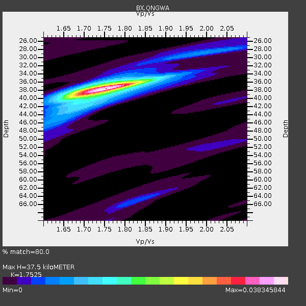
| Thickness Estimate: | 38 km |
| Thickness StdDev: | 0.3 km |
| Vp/Vs Estimate: | 1.75 |
| Vp/Vs StdDev: | 0.01 |
| Vs Estimate: | 3.753 km/s |
| Poisson's Ratio: | 0.26 |
| Peak Value: | 0.04 |
| Assumed Vp: | 6.577 km/s |
| Ps Weight: | 0.33333334 |
| PpPs Weight: | 0.33333334 |
| PsPs Weight: | 0.33333328 |
| Residual Complexity: | 0.304 |
| Nearby stations H: | 38 km +- 0.0 km |
| (2.0 deg) Vp/Vs: | 1.72 +- 0.03 |
7 with match > 90% ( 12.962963 %) and 13 with match > 80% ( 24.074074 %) out of 54.
Download stack as xyz text file.
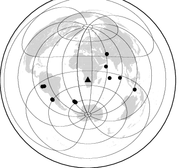
Azimuth Distribution of Events:
Prior Results for this Station
| Study | Thickness | Vp/Vs | Vp | Vs | Poissons Ratio | Extra |
| EARS | 38 km | 1.75 | 6.577 km/s | 3.753 km/s | 0.26 | |
| Crust2.0 | 46 km | 1.78 | 6.577 km/s | 3.701 km/s | 0.27 | H3,early/mid Proter. shield, Finland, 0.5 km seds. |
| Global Maxima | 38 km | 1.75 | 6.577 km/s | 3.753 km/s | 0.26 | amp=0.038345844 |
| Local Maxima 1 | 36 km | 1.76 | 6.577 km/s | 3.737 km/s | 0.26 | amp=0.009791001 |
| Local Maxima 2 | 28 km | 2.02 | 6.577 km/s | 3.264 km/s | 0.34 | amp=0.0061029876 |
| Local Maxima 3 | 39 km | 1.76 | 6.577 km/s | 3.737 km/s | 0.26 | amp=0.0057072495 |
| Local Maxima 4 | 65 km | 1.82 | 6.577 km/s | 3.614 km/s | 0.28 | amp=0.0054095928 |
| Predicted Arrivals for vertical incidence (zero ray parameter) | |
| Ps | 4.29 SECOND |
| PpPs | 15.69 SECOND |
| PsPs/PpSs | 19.98 SECOND |
Events Processed for this Station
Download zip of receiver functions as SAC
Plot maxima for each earthquake.
Events Used in the Stack
(13 events)| Radial Match | Distance | Baz | FERegion | Time | Lat/Lon | Depth | Magnitude |
| 98.6623 | 52.0 deg | 209.411 deg | South Sandwich Islands Region | 2018/12/11 02:26:32 UTC | (-58.6, -26.5) | 165 km | 7.1 mww |
| 97.67752 | 94.1 deg | 262.303 deg | Northern Peru | 2019/05/26 07:41:13 UTC | (-5.9, -75.3) | 105 km | 7.5 Mi |
| 96.90857 | 83.1 deg | 242.058 deg | Near Coast Of Central Chile | 2023/10/31 12:33:44 UTC | (-28.7, -71.6) | 41 km | 6.7 mww |
| 95.988846 | 51.4 deg | 209.04 deg | South Sandwich Islands Region | 2019/04/09 17:53:59 UTC | (-58.6, -25.3) | 46 km | 6.5 Mww |
| 90.8098 | 46.6 deg | 52.693 deg | Carlsberg Ridge | 2019/04/29 14:19:52 UTC | (10.9, 57.2) | 10 km | 6.3 Mww |
| 90.56953 | 66.4 deg | 36.085 deg | Northwestern Afghanistan | 2023/10/15 03:36:00 UTC | (34.6, 62.1) | 8.2 km | 6.3 Mww |
| 90.224205 | 90.1 deg | 262.254 deg | Western Brazil | 2024/01/20 21:31:07 UTC | (-7.3, -71.5) | 629 km | 6.5 Mww |
| 86.2582 | 82.6 deg | 240.832 deg | Near Coast Of Central Chile | 2019/01/20 01:32:51 UTC | (-30.1, -71.4) | 53 km | 6.7 mww |
| 85.781456 | 66.0 deg | 85.646 deg | South Indian Ocean | 2023/11/14 07:00:56 UTC | (-4.0, 87.1) | 10 km | 6.1 mww |
| 84.46486 | 97.8 deg | 101.097 deg | Flores Sea | 2021/12/14 03:20:24 UTC | (-7.8, 122.3) | 76 km | 7.6 Mi |
| 82.43489 | 51.5 deg | 212.888 deg | South Sandwich Islands Region | 2019/04/05 16:14:16 UTC | (-55.9, -27.8) | 58 km | 6.5 mww |
| 81.392914 | 44.8 deg | 84.066 deg | Mid-Indian Ridge | 2019/03/30 06:27:23 UTC | (-9.7, 66.5) | 10 km | 5.9 Mww |
| 80.171265 | 66.3 deg | 35.995 deg | Northwestern Afghanistan | 2023/10/07 06:41:02 UTC | (34.6, 61.9) | 10 km | 6.2 mww |
Losers
(41 events)| Radial Match | Distance | Baz | FERegion | Time | Lat/Lon | Depth | Magnitude | Reason |
| 93.13658 | 66.3 deg | 36.023 deg | Northwestern Afghanistan | 2023/10/07 07:12:50 UTC | (34.5, 61.9) | 11 km | 6.2 mww | |
| 74.94454 | 51.4 deg | 212.322 deg | South Sandwich Islands Region | 2023/11/30 07:54:57 UTC | (-56.3, -27.4) | 99 km | 5.8 mww | |
| 73.67909 | 90.1 deg | 253.499 deg | Near Coast Of Peru | 2021/04/25 23:50:30 UTC | (-15.6, -74.6) | 13 km | 5.5 mww | |
| 72.61578 | 89.9 deg | 261.461 deg | Western Brazil | 2019/01/05 19:25:38 UTC | (-8.1, -71.6) | 575 km | 6.8 Mww | |
| 72.268486 | 83.2 deg | 240.661 deg | Off Coast Of Central Chile | 2019/06/14 00:19:10 UTC | (-30.0, -72.2) | 10 km | 6.5 Mww | |
| 72.137535 | 64.4 deg | 211.023 deg | Scotia Sea | 2019/11/28 00:26:29 UTC | (-60.9, -50.9) | 10 km | 5.6 Mww | |
| 69.86411 | 82.0 deg | 239.176 deg | Near Coast Of Central Chile | 2019/11/04 21:53:24 UTC | (-31.8, -71.4) | 49 km | 6.0 Mww | |
| 69.509224 | 83.1 deg | 241.908 deg | Near Coast Of Central Chile | 2024/02/14 01:31:41 UTC | (-28.9, -71.5) | 22 km | 6.0 mww | |
| 68.16289 | 51.4 deg | 212.376 deg | South Sandwich Islands Region | 2024/03/20 05:48:21 UTC | (-56.3, -27.4) | 118 km | 5.6 mww | |
| 67.69774 | 76.2 deg | 244.72 deg | Santiago Del Estero Prov., Arg. | 2023/08/05 07:20:07 UTC | (-28.2, -63.2) | 598 km | 6.2 Mww | |
| 67.29209 | 51.5 deg | 212.658 deg | South Sandwich Islands Region | 2023/12/20 12:09:14 UTC | (-56.1, -27.8) | 117 km | 5.6 Mww | |
| 66.98081 | 57.8 deg | 28.566 deg | Western Iran | 2019/07/08 07:00:31 UTC | (31.8, 49.5) | 10 km | 5.7 mb | |
| 66.88205 | 83.6 deg | 112.377 deg | Western Australia | 2018/12/16 14:26:19 UTC | (-23.3, 112.5) | 10 km | 5.8 Mww | |
| 65.68641 | 51.4 deg | 212.351 deg | South Sandwich Islands Region | 2019/04/22 14:49:06 UTC | (-56.3, -27.4) | 94 km | 6.0 Mww | |
| 64.03899 | 82.4 deg | 243.711 deg | Near Coast Of Northern Chile | 2019/06/05 16:19:42 UTC | (-27.4, -70.2) | 75 km | 5.3 Mww | |
| 63.659874 | 45.9 deg | 204.35 deg | East Of South Sandwich Islands | 2023/07/04 12:01:02 UTC | (-58.2, -12.8) | 10 km | 5.9 mww | |
| 62.506886 | 87.6 deg | 68.527 deg | Laos | 2019/11/20 23:50:44 UTC | (19.5, 101.3) | 10 km | 6.1 Mww | |
| 61.322098 | 39.0 deg | 28.922 deg | Ethiopia | 2023/08/01 17:15:25 UTC | (15.2, 39.5) | 10 km | 5.6 mww | |
| 60.624527 | 51.2 deg | 209.754 deg | South Sandwich Islands Region | 2019/06/24 19:21:37 UTC | (-58.0, -25.4) | 35 km | 5.5 Mww | |
| 60.493786 | 44.2 deg | 290.71 deg | Central Mid-Atlantic Ridge | 2023/08/17 16:41:02 UTC | (-0.3, -19.6) | 10 km | 6.0 Mww | |
| 60.048035 | 83.2 deg | 246.469 deg | Near Coast Of Northern Chile | 2019/03/28 15:05:32 UTC | (-24.5, -70.1) | 59 km | 5.4 Mww | |
| 58.036465 | 89.2 deg | 95.82 deg | Java Sea | 2024/03/22 04:22:45 UTC | (-5.8, 112.3) | 10 km | 5.6 Mww | |
| 56.67627 | 84.0 deg | 251.846 deg | Northern Chile | 2023/12/02 07:55:40 UTC | (-19.2, -69.1) | 106 km | 5.8 Mww | |
| 54.69674 | 94.4 deg | 159.331 deg | Macquarie Island Region | 2024/03/16 00:14:52 UTC | (-58.9, 158.5) | 10 km | 5.9 mww | |
| 53.896614 | 42.3 deg | 293.225 deg | North Of Ascension Island | 2020/01/06 01:29:20 UTC | (0.2, -17.0) | 10 km | 5.6 Mww | |
| 53.88659 | 56.9 deg | 36.286 deg | Southern Iran | 2019/10/21 10:58:52 UTC | (27.2, 55.0) | 10 km | 5.4 Mww | |
| 53.56625 | 74.6 deg | 45.858 deg | Kashmir-India Border Region | 2023/12/18 10:18:53 UTC | (33.2, 76.8) | 10 km | 5.1 Mww | |
| 52.98653 | 68.1 deg | 134.848 deg | Southeast Indian Ridge | 2019/06/25 06:01:49 UTC | (-48.0, 99.6) | 10 km | 5.8 Mww | |
| 49.568718 | 83.1 deg | 246.478 deg | Near Coast Of Northern Chile | 2023/11/27 10:08:25 UTC | (-24.6, -70.0) | 61 km | 5.0 Mwr | |
| 48.84411 | 38.9 deg | 293.709 deg | North Of Ascension Island | 2024/01/25 23:01:02 UTC | (-1.2, -14.0) | 10 km | 5.5 mww | |
| 48.353016 | 68.8 deg | 82.326 deg | South Indian Ocean | 2023/07/01 07:29:40 UTC | (-0.1, 88.7) | 10 km | 5.8 mww | |
| 48.12109 | 91.0 deg | 146.86 deg | Western Indian-Antarctic Ridge | 2023/10/13 03:44:32 UTC | (-51.8, 139.5) | 4.9 km | 6.0 mww | |
| 47.760406 | 83.2 deg | 242.601 deg | Near Coast Of Central Chile | 2024/02/11 21:14:43 UTC | (-28.2, -71.4) | 34 km | 5.4 Mww | |
| 47.21989 | 86.1 deg | 52.944 deg | Qinghai, China | 2022/08/14 08:20:01 UTC | (33.2, 92.8) | 10 km | 5.5 mww | |
| 46.008816 | 51.1 deg | 209.287 deg | South Sandwich Islands Region | 2024/02/14 04:30:58 UTC | (-58.3, -25.0) | 35 km | 5.7 Mww | |
| 45.63283 | 78.5 deg | 88.504 deg | Southern Sumatra, Indonesia | 2019/10/22 22:11:06 UTC | (-2.4, 99.8) | 12 km | 5.1 Mww | |
| 45.43589 | 36.5 deg | 115.018 deg | Southwest Indian Ridge | 2023/07/28 07:03:06 UTC | (-30.5, 59.8) | 10 km | 5.6 Mww | |
| 45.08439 | 78.2 deg | 85.087 deg | Northern Sumatra, Indonesia | 2019/06/02 03:03:07 UTC | (0.7, 98.5) | 26 km | 5.3 Mww | |
| 43.077446 | 51.6 deg | 212.401 deg | South Sandwich Islands Region | 2019/05/27 23:29:31 UTC | (-56.3, -27.8) | 111 km | 5.7 Mww | |
| 42.77296 | 77.3 deg | 73.915 deg | Andaman Islands, India Region | 2023/07/28 19:23:48 UTC | (10.5, 93.5) | 102 km | 5.9 mww | |
| 39.306526 | 89.6 deg | 291.285 deg | North Atlantic Ocean | 2023/07/10 20:28:25 UTC | (20.0, -61.1) | 10 km | 6.6 mww |

