
Station BX XAUDM - Xaudum
Network: BX - Botswana Seismological Network
Nearby stations (2 deg radius)
| Station | Name | (Lat, Lon) | Start / End | Elevation |
| XAUDM | Xaudum | (-18.54, 21.34) | 2018-02-17 / 2599-12-31 | 1060 m |
| Crust2 Type: | H3,early/mid Proter. shield, Finland, 0.5 km seds. |
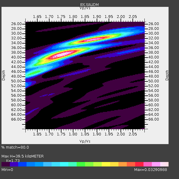
| Thickness Estimate: | 40 km |
| Thickness StdDev: | 3.4 km |
| Vp/Vs Estimate: | 1.73 |
| Vp/Vs StdDev: | 0.07 |
| Vs Estimate: | 3.802 km/s |
| Poisson's Ratio: | 0.25 |
| Peak Value: | 0.03 |
| Assumed Vp: | 6.577 km/s |
| Ps Weight: | 0.33333334 |
| PpPs Weight: | 0.33333334 |
| PsPs Weight: | 0.33333328 |
| Residual Complexity: | 0.646 |
| Nearby stations H: | 40 km +- 0.7 km |
| (2.0 deg) Vp/Vs: | 1.72 +- 0.02 |
7 with match > 90% ( 12.280702 %) and 15 with match > 80% ( 26.31579 %) out of 57.
Download stack as xyz text file.
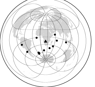
Azimuth Distribution of Events:
Prior Results for this Station
| Study | Thickness | Vp/Vs | Vp | Vs | Poissons Ratio | Extra |
| EARS | 40 km | 1.73 | 6.577 km/s | 3.802 km/s | 0.25 | |
| Crust2.0 | 46 km | 1.78 | 6.577 km/s | 3.701 km/s | 0.27 | H3,early/mid Proter. shield, Finland, 0.5 km seds. |
| Global Maxima | 40 km | 1.73 | 6.577 km/s | 3.802 km/s | 0.25 | amp=0.03290988 |
| Local Maxima 1 | 32 km | 1.89 | 6.577 km/s | 3.471 km/s | 0.31 | amp=0.028989501 |
| Local Maxima 2 | 38 km | 1.77 | 6.577 km/s | 3.716 km/s | 0.27 | amp=0.015202075 |
| Local Maxima 3 | 42 km | 1.67 | 6.577 km/s | 3.944 km/s | 0.22 | amp=0.009991652 |
| Local Maxima 4 | 46 km | 1.64 | 6.577 km/s | 4.01 km/s | 0.20 | amp=0.006690013 |
| Predicted Arrivals for vertical incidence (zero ray parameter) | |
| Ps | 4.38 SECOND |
| PpPs | 16.40 SECOND |
| PsPs/PpSs | 20.78 SECOND |
Events Processed for this Station
Download zip of receiver functions as SAC
Plot maxima for each earthquake.
Events Used in the Stack
(15 events)| Radial Match | Distance | Baz | FERegion | Time | Lat/Lon | Depth | Magnitude |
| 98.24998 | 52.9 deg | 209.092 deg | South Sandwich Islands Region | 2018/12/11 02:26:32 UTC | (-58.6, -26.5) | 165 km | 7.1 mww |
| 98.02484 | 94.4 deg | 262.321 deg | Northern Peru | 2019/05/26 07:41:13 UTC | (-5.9, -75.3) | 105 km | 7.5 Mi |
| 97.075226 | 52.8 deg | 208.861 deg | South Sandwich Islands Region | 2022/10/25 00:13:02 UTC | (-58.7, -26.2) | 82 km | 6.3 Mww |
| 96.57414 | 52.4 deg | 208.721 deg | South Sandwich Islands Region | 2019/04/09 17:53:59 UTC | (-58.6, -25.3) | 46 km | 6.5 Mww |
| 92.378685 | 38.6 deg | 292.709 deg | North Of Ascension Island | 2019/10/23 16:08:14 UTC | (-1.1, -13.8) | 10 km | 6.3 mww |
| 91.361015 | 45.9 deg | 53.303 deg | Carlsberg Ridge | 2019/04/29 14:19:52 UTC | (10.9, 57.2) | 10 km | 6.3 Mww |
| 91.30633 | 30.2 deg | 148.623 deg | Prince Edward Islands Region | 2019/01/22 19:01:43 UTC | (-43.1, 42.3) | 13 km | 6.7 Mww |
| 89.093475 | 44.6 deg | 84.989 deg | Mid-Indian Ridge | 2019/03/30 06:27:23 UTC | (-9.7, 66.5) | 10 km | 5.9 Mww |
| 87.71214 | 54.3 deg | 207.4 deg | South Sandwich Islands Region | 2021/10/04 03:54:06 UTC | (-60.4, -27.5) | 10 km | 6.2 mww |
| 87.07133 | 52.4 deg | 212.52 deg | South Sandwich Islands Region | 2019/04/05 16:14:16 UTC | (-55.9, -27.8) | 58 km | 6.5 mww |
| 86.55428 | 83.2 deg | 240.682 deg | Near Coast Of Central Chile | 2019/01/20 01:32:51 UTC | (-30.1, -71.4) | 53 km | 6.7 mww |
| 83.54789 | 34.6 deg | 123.031 deg | Southwest Indian Ridge | 2019/09/24 21:19:47 UTC | (-33.8, 56.2) | 10 km | 6.1 Mww |
| 82.00578 | 51.5 deg | 212.316 deg | South Sandwich Islands Region | 2019/11/02 18:08:41 UTC | (-55.7, -26.3) | 10 km | 6.1 Mww |
| 81.47697 | 35.1 deg | 190.471 deg | Southwest Of Africa | 2019/12/09 17:59:47 UTC | (-52.8, 11.4) | 10 km | 5.6 Mww |
| 80.594894 | 80.6 deg | 92.223 deg | Southern Sumatra, Indonesia | 2022/08/23 14:31:40 UTC | (-5.1, 103.1) | 59 km | 6.0 Mww |
Losers
(42 events)| Radial Match | Distance | Baz | FERegion | Time | Lat/Lon | Depth | Magnitude | Reason |
| 80.33523 | 77.6 deg | 87.003 deg | Southern Sumatra, Indonesia | 2022/09/10 23:10:44 UTC | (-1.1, 98.6) | 20 km | 6.0 Mww | |
| 79.745735 | 83.0 deg | 228.824 deg | Off Coast Of Southern Chile | 2022/09/23 22:53:26 UTC | (-41.4, -75.6) | 10 km | 6.1 mww | |
| 75.84357 | 37.9 deg | 195.307 deg | Bouvet Island Region | 2020/01/12 02:27:00 UTC | (-54.4, 5.2) | 10 km | 5.6 Mww | |
| 73.717476 | 53.1 deg | 208.332 deg | South Sandwich Islands Region | 2020/01/20 06:51:37 UTC | (-59.2, -26.3) | 91 km | 6.1 Mww | |
| 73.1055 | 51.6 deg | 211.135 deg | South Sandwich Islands Region | 2022/09/06 08:32:40 UTC | (-56.6, -25.8) | 10 km | 6.0 mww | |
| 72.18192 | 52.3 deg | 211.989 deg | South Sandwich Islands Region | 2019/04/22 14:49:06 UTC | (-56.3, -27.4) | 94 km | 6.0 Mww | |
| 72.0008 | 90.2 deg | 261.408 deg | Western Brazil | 2019/01/05 19:25:38 UTC | (-8.1, -71.6) | 575 km | 6.8 Mww | |
| 70.16579 | 81.2 deg | 247.781 deg | Chile-Argentina Border Region | 2021/09/13 05:18:13 UTC | (-23.9, -67.0) | 193 km | 6.2 mww | |
| 68.6798 | 86.9 deg | 48.616 deg | Qinghai, China | 2022/10/19 04:35:35 UTC | (37.7, 92.3) | 8.6 km | 5.5 Mww | |
| 64.8588 | 87.1 deg | 68.514 deg | Laos | 2019/11/20 23:50:44 UTC | (19.5, 101.3) | 10 km | 6.1 Mww | |
| 63.6214 | 86.9 deg | 330.438 deg | Reykjanes Ridge | 2022/09/26 09:59:56 UTC | (54.0, -35.2) | 10 km | 5.7 mww | |
| 63.57574 | 51.5 deg | 208.907 deg | South Sandwich Islands Region | 2021/08/17 03:10:50 UTC | (-58.0, -24.0) | 10 km | 5.7 Mww | |
| 62.15823 | 77.2 deg | 245.659 deg | Santiago Del Estero Prov., Arg. | 2019/12/24 16:43:32 UTC | (-27.0, -63.4) | 560 km | 6.0 Mww | |
| 61.41731 | 56.0 deg | 36.538 deg | Southern Iran | 2019/10/21 10:58:52 UTC | (27.2, 55.0) | 10 km | 5.4 Mww | |
| 61.353317 | 94.6 deg | 288.59 deg | Mona Passage | 2019/09/24 03:23:33 UTC | (19.2, -67.2) | 10 km | 6.3 Mi | |
| 60.74892 | 86.1 deg | 251.862 deg | Near Coast Of Northern Chile | 2019/12/03 08:46:36 UTC | (-18.6, -70.7) | 32 km | 6.0 Mww | |
| 60.336456 | 48.8 deg | 76.691 deg | Carlsberg Ridge | 2019/09/05 09:12:20 UTC | (-2.5, 68.5) | 10 km | 5.6 Mww | |
| 60.276318 | 55.7 deg | 31.009 deg | Southern Iran | 2021/04/18 06:41:50 UTC | (29.8, 50.7) | 10 km | 5.8 mww | |
| 57.80853 | 34.3 deg | 183.162 deg | Southwest Of Africa | 2021/08/03 06:43:00 UTC | (-52.8, 18.4) | 10 km | 5.5 Mww | |
| 56.979855 | 83.8 deg | 240.519 deg | Off Coast Of Central Chile | 2019/06/14 00:19:10 UTC | (-30.0, -72.2) | 10 km | 6.5 Mww | |
| 55.427235 | 52.7 deg | 208.278 deg | South Sandwich Islands Region | 2021/09/01 09:01:11 UTC | (-59.1, -25.6) | 27 km | 5.6 Mww | |
| 54.936913 | 90.6 deg | 253.451 deg | Near Coast Of Peru | 2021/04/25 23:50:30 UTC | (-15.6, -74.6) | 13 km | 5.5 mww | |
| 54.52478 | 88.6 deg | 95.912 deg | Java, Indonesia | 2019/09/19 07:32:00 UTC | (-6.1, 111.9) | 591 km | 6.0 Mww | |
| 53.466217 | 71.8 deg | 39.864 deg | Hindu Kush Region, Afghanistan | 2019/12/20 11:39:52 UTC | (36.5, 70.4) | 210 km | 6.1 Mww | |
| 52.03283 | 93.0 deg | 50.395 deg | Gansu, China | 2019/09/16 12:48:40 UTC | (38.6, 100.2) | 13 km | 5.5 mb | |
| 50.378426 | 86.6 deg | 54.787 deg | Xizang | 2020/01/24 22:56:05 UTC | (32.0, 95.0) | 10 km | 5.5 mb | |
| 49.652733 | 98.1 deg | 94.685 deg | Sulawesi, Indonesia | 2019/03/24 01:31:59 UTC | (-1.8, 120.5) | 10 km | 5.4 Mww | |
| 48.976936 | 88.6 deg | 95.877 deg | Java, Indonesia | 2019/09/19 07:32:58 UTC | (-6.0, 111.9) | 638 km | 5.7 mb | |
| 48.686047 | 83.0 deg | 236.864 deg | Off Coast Of Central Chile | 2019/04/07 10:52:40 UTC | (-33.8, -72.5) | 10 km | 5.7 Mww | |
| 48.007935 | 36.6 deg | 235.35 deg | Tristan Da Cunha Region | 2019/04/16 07:30:38 UTC | (-35.3, -15.5) | 10 km | 5.7 mb | |
| 47.489346 | 35.1 deg | 121.048 deg | Southwest Indian Ridge | 2019/02/08 03:11:05 UTC | (-32.8, 57.1) | 10 km | 5.5 Mww | |
| 47.30231 | 96.2 deg | 271.566 deg | Colombia | 2019/12/24 19:19:03 UTC | (3.5, -74.1) | 10 km | 5.6 Mww | |
| 46.11058 | 54.9 deg | 5.608 deg | Dodecanese Islands, Greece | 2021/06/21 22:14:13 UTC | (36.4, 27.0) | 8.9 km | 5.5 mww | |
| 45.784725 | 63.6 deg | 129.84 deg | Southeast Indian Ridge | 2021/07/03 11:58:07 UTC | (-43.4, 92.1) | 10 km | 5.7 mww | |
| 45.653194 | 98.4 deg | 156.593 deg | Macquarie Island Region | 2022/08/16 07:09:48 UTC | (-54.8, 158.6) | 10 km | 5.5 Mww | |
| 42.583015 | 86.9 deg | 330.099 deg | Reykjanes Ridge | 2022/10/01 01:18:53 UTC | (53.7, -35.5) | 10 km | 6.0 mww | |
| 34.699436 | 93.6 deg | 263.925 deg | Peru-Brazil Border Region | 2019/01/08 10:00:09 UTC | (-4.6, -74.0) | 10 km | 5.1 Mww | |
| 34.165226 | 52.5 deg | 212.041 deg | South Sandwich Islands Region | 2019/05/27 23:29:31 UTC | (-56.3, -27.8) | 111 km | 5.7 Mww | |
| 33.69992 | 34.6 deg | 178.006 deg | South Of Africa | 2020/01/10 20:59:43 UTC | (-53.2, 23.2) | 10 km | 5.4 Mww | |
| 29.315006 | 56.3 deg | 37.272 deg | Southern Iran | 2020/02/16 12:30:47 UTC | (27.1, 55.8) | 10 km | 5.1 Mww | |
| 24.79879 | 97.6 deg | 270.704 deg | Colombia | 2019/01/28 21:07:10 UTC | (3.1, -75.7) | 15 km | 5.5 Mww | |
| 9.808023 | 78.0 deg | 85.237 deg | Northern Sumatra, Indonesia | 2019/06/02 03:03:07 UTC | (0.7, 98.5) | 26 km | 5.3 Mww |

