
Station C8 SV1S - Aquistore NE01, SK, CA
Network: C8 - Canadian Seismic Research Network ()
Nearby stations (2 deg radius)
| Station | Name | (Lat, Lon) | Start / End | Elevation |
| SV1S | Aquistore NE01, SK, CA | (49.10, -103.07) | 2013-10-31 / 2499-01-01 | 553 m |
| Crust2 Type: | H5,early/mid Proter. shield, Africa, 3 km seds. |
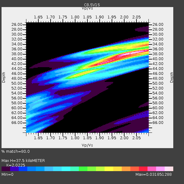
| Thickness Estimate: | 38 km |
| Thickness StdDev: | 7.4 km |
| Vp/Vs Estimate: | 2.02 |
| Vp/Vs StdDev: | 0.13 |
| Vs Estimate: | 3.183 km/s |
| Poisson's Ratio: | 0.34 |
| Peak Value: | 0.03 |
| Assumed Vp: | 6.438 km/s |
| Ps Weight: | 0.33333334 |
| PpPs Weight: | 0.33333334 |
| PsPs Weight: | 0.33333328 |
| Residual Complexity: | 0.746 |
| Nearby stations H: | 43 km +- 7.8 km |
| (2.0 deg) Vp/Vs: | 1.90 +- 0.15 |
3 with match > 90% ( 10.714286 %) and 6 with match > 80% ( 21.428572 %) out of 28.
Download stack as xyz text file.
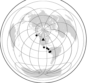
Azimuth Distribution of Events:
Prior Results for this Station
| Study | Thickness | Vp/Vs | Vp | Vs | Poissons Ratio | Extra |
| EARS | 38 km | 2.02 | 6.438 km/s | 3.183 km/s | 0.34 | |
| Crust2.0 | 48 km | 1.78 | 6.438 km/s | 3.613 km/s | 0.27 | H5,early/mid Proter. shield, Africa, 3 km seds. |
| Global Maxima | 38 km | 2.02 | 6.438 km/s | 3.183 km/s | 0.34 | amp=0.031851288 |
| Local Maxima 1 | 42 km | 1.89 | 6.438 km/s | 3.397 km/s | 0.31 | amp=0.023429707 |
| Local Maxima 2 | 36 km | 1.92 | 6.438 km/s | 3.344 km/s | 0.32 | amp=0.01918758 |
| Local Maxima 3 | 44 km | 1.99 | 6.438 km/s | 3.231 km/s | 0.33 | amp=0.014083008 |
| Local Maxima 4 | 38 km | 2.07 | 6.438 km/s | 3.117 km/s | 0.35 | amp=0.012814146 |
| Predicted Arrivals for vertical incidence (zero ray parameter) | |
| Ps | 5.96 SECOND |
| PpPs | 17.61 SECOND |
| PsPs/PpSs | 23.56 SECOND |
Events Processed for this Station
Download zip of receiver functions as SAC
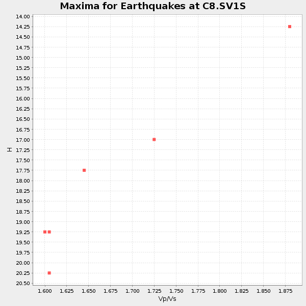
Plot maxima for each earthquake.
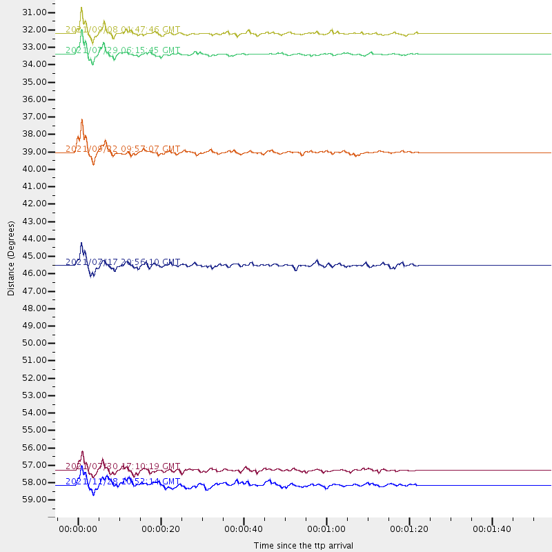
Events Used in the Stack
(6 events)| Radial Match | Distance | Baz | FERegion | Time | Lat/Lon | Depth | Magnitude |
| 96.772865 | 33.4 deg | 301.895 deg | Alaska Peninsula | 2021/07/29 06:15:45 UTC | (55.3, -157.8) | 5.2 km | 7.3 ml |
| 92.16176 | 57.3 deg | 153.083 deg | Peru-Ecuador Border Region | 2021/07/30 17:10:19 UTC | (-4.9, -80.6) | 33 km | 6.2 Mww |
| 91.52819 | 39.0 deg | 155.835 deg | Near Coast Of Nicaragua | 2021/09/22 09:57:07 UTC | (12.1, -87.8) | 10 km | 6.7 Mi |
| 88.726944 | 58.1 deg | 148.561 deg | Northern Peru | 2021/11/28 10:52:14 UTC | (-4.5, -76.7) | 99 km | 7.4 Mi |
| 88.554184 | 32.2 deg | 174.089 deg | Near Coast Of Guerrero, Mexico | 2021/09/08 01:47:46 UTC | (17.0, -99.8) | 13 km | 7.0 mww |
| 87.10765 | 45.5 deg | 150.983 deg | South Of Panama | 2021/07/17 20:56:10 UTC | (6.8, -82.7) | 4.1 km | 6.1 mww |
Losers
(22 events)| Radial Match | Distance | Baz | FERegion | Time | Lat/Lon | Depth | Magnitude | Reason |
| 93.31194 | 32.5 deg | 303.351 deg | Alaska Peninsula | 2021/10/11 09:10:24 UTC | (56.3, -156.6) | 69 km | 6.9 mww | |
| 78.41941 | 46.7 deg | 302.751 deg | Andreanof Islands, Aleutian Is. | 2021/09/24 11:52:31 UTC | (51.1, -178.9) | 50 km | 6.3 Mi | |
| 77.95191 | 79.5 deg | 146.77 deg | Chile-Argentina Border Region | 2021/09/13 05:18:13 UTC | (-23.9, -67.0) | 193 km | 6.2 mww | |
| 76.53397 | 60.7 deg | 153.552 deg | Near Coast Of Northern Peru | 2021/07/29 00:32:13 UTC | (-8.3, -80.0) | 23 km | 5.8 Mww | |
| 74.36504 | 51.6 deg | 253.375 deg | Hawaii | 2021/10/10 21:48:36 UTC | (18.8, -155.5) | 35 km | 6.2 Ml | |
| 74.14783 | 64.8 deg | 144.853 deg | Peru-Brazil Border Region | 2021/10/02 12:52:34 UTC | (-9.6, -71.2) | 589 km | 5.9 mww | |
| 71.03128 | 74.0 deg | 192.236 deg | Southern East Pacific Rise | 2021/09/03 05:22:58 UTC | (-24.3, -116.0) | 10 km | 5.4 Mww | |
| 69.98064 | 39.9 deg | 300.688 deg | Fox Islands, Aleutian Islands | 2021/11/04 08:57:06 UTC | (52.7, -168.0) | 36 km | 5.2 Mww | |
| 63.185543 | 45.0 deg | 14.126 deg | Greenland Sea | 2021/07/23 04:05:40 UTC | (79.7, 3.6) | 10 km | 5.5 mww | |
| 61.99717 | 40.2 deg | 154.328 deg | Near Coast Of Nicaragua | 2021/11/09 06:25:17 UTC | (11.2, -86.5) | 35 km | 6.2 mww | |
| 60.260395 | 84.3 deg | 40.181 deg | Crete, Greece | 2021/09/27 06:17:22 UTC | (35.3, 25.3) | 8.7 km | 6.0 mww | |
| 58.28554 | 32.9 deg | 301.784 deg | South Of Alaska | 2021/07/30 03:52:15 UTC | (55.4, -157.0) | 33 km | 5.5 Mww | |
| 57.376133 | 40.2 deg | 154.608 deg | Near Coast Of Nicaragua | 2021/11/09 02:53:49 UTC | (11.2, -86.7) | 17 km | 5.9 mww | |
| 55.65427 | 32.9 deg | 301.645 deg | South Of Alaska | 2021/07/29 20:32:44 UTC | (55.3, -156.9) | 45 km | 5.5 ml | |
| 55.508907 | 65.1 deg | 312.334 deg | Kuril Islands | 2021/07/13 00:30:16 UTC | (46.2, 151.7) | 33 km | 5.6 Mww | |
| 54.811703 | 78.3 deg | 317.154 deg | Sea Of Japan | 2021/09/29 08:37:05 UTC | (38.9, 135.5) | 368 km | 6.1 Mww | |
| 53.721786 | 63.2 deg | 316.315 deg | Sea Of Okhotsk | 2021/10/09 07:19:27 UTC | (50.0, 149.8) | 448 km | 5.6 Mww | |
| 51.865406 | 46.7 deg | 302.89 deg | Andreanof Islands, Aleutian Is. | 2021/09/24 07:02:28 UTC | (51.1, -179.0) | 18 km | 5.5 Mww | |
| 48.97694 | 95.4 deg | 22.872 deg | Western Iran | 2021/10/04 02:39:27 UTC | (32.3, 49.8) | 10 km | 5.6 mww | |
| 45.61766 | 39.1 deg | 155.665 deg | Near Coast Of Nicaragua | 2021/09/22 12:57:00 UTC | (12.1, -87.7) | 33 km | 5.6 mww | |
| 44.9681 | 64.9 deg | 317.355 deg | Sea Of Okhotsk | 2021/09/03 10:14:26 UTC | (49.5, 147.0) | 582 km | 5.8 Mww | |
| 42.32515 | 66.6 deg | 146.257 deg | Central Peru | 2021/10/10 00:20:41 UTC | (-11.7, -71.7) | 13 km | 5.7 mww |

