
Station C8 TOFB - Tofino, BC, CA
Network: C8 - Canadian Seismic Research Network ()
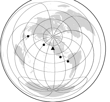
Nearby stations (2 deg radius)
| Station | Name | (Lat, Lon) | Start / End | Elevation |
| TOFB | Tofino, BC, CA | (49.15, -125.91) | 2009-02-14 / 2499-01-01 | 13 m |
| Crust2 Type: | T4,Margin /shield transition, East Siberia, 2 km seds. |
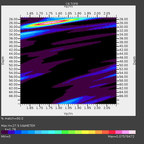
| Thickness Estimate: | 28 km |
| Thickness StdDev: | 1.4 km |
| Vp/Vs Estimate: | 1.76 |
| Vp/Vs StdDev: | 0.03 |
| Vs Estimate: | 3.631 km/s |
| Poisson's Ratio: | 0.26 |
| Peak Value: | 0.08 |
| Assumed Vp: | 6.391 km/s |
| Ps Weight: | 0.33333334 |
| PpPs Weight: | 0.33333334 |
| PsPs Weight: | 0.33333328 |
| Residual Complexity: | 0.295 |
| Nearby stations H: | +- |
| (2.0 deg) Vp/Vs: | +- |
2 with match > 90% ( 6.8965516 %) and 4 with match > 80% ( 13.793103 %) out of 29.
Download stack as xyz text file.
Azimuth Distribution of Events:
Prior Results for this Station
| Study | Thickness | Vp/Vs | Vp | Vs | Poissons Ratio | Extra |
| EARS | 28 km | 1.76 | 6.391 km/s | 3.631 km/s | 0.26 | |
| Crust2.0 | 32 km | 1.79 | 6.391 km/s | 3.572 km/s | 0.27 | T4,Margin /shield transition, East Siberia, 2 km seds. |
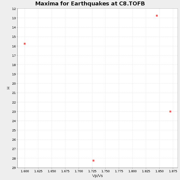
| Global Maxima | 28 km | 1.76 | 6.391 km/s | 3.631 km/s | 0.26 | amp=0.07578472 |
| Local Maxima 1 | 68 km | 1.86 | 6.391 km/s | 3.44 km/s | 0.30 | amp=0.020471226 |
| Local Maxima 2 | 57 km | 1.60 | 6.391 km/s | 3.994 km/s | 0.18 | amp=0.013827831 |
| Local Maxima 3 | 55 km | 2.09 | 6.391 km/s | 3.054 km/s | 0.35 | amp=0.013652283 |
| Local Maxima 4 | 34 km | 1.62 | 6.391 km/s | 3.945 km/s | 0.19 | amp=0.013350423 |
| Predicted Arrivals for vertical incidence (zero ray parameter) | |
| Ps | 3.27 SECOND |
| PpPs | 11.88 SECOND |
| PsPs/PpSs | 15.15 SECOND |
Events Processed for this Station
Download zip of receiver functions as SAC
Plot maxima for each earthquake.
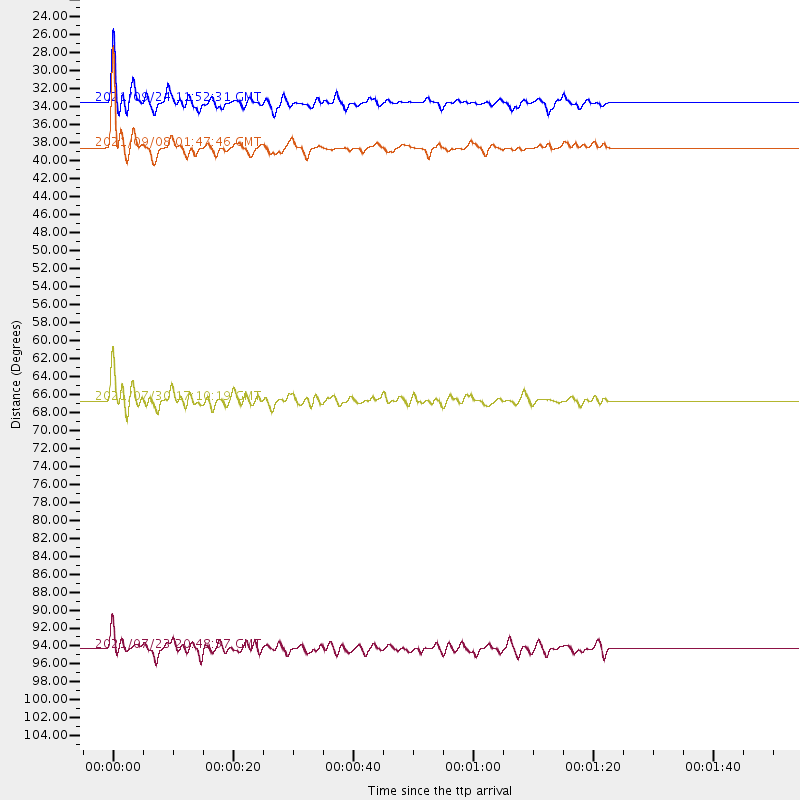
Events Used in the Stack
(4 events)| Radial Match | Distance | Baz | FERegion | Time | Lat/Lon | Depth | Magnitude |
| 91.28963 | 66.7 deg | 129.54 deg | Peru-Ecuador Border Region | 2021/07/30 17:10:19 UTC | (-4.9, -80.6) | 33 km | 6.2 Mww |
| 90.956795 | 38.5 deg | 137.384 deg | Near Coast Of Guerrero, Mexico | 2021/09/08 01:47:46 UTC | (17.0, -99.8) | 13 km | 7.0 mww |
| 89.42604 | 33.5 deg | 293.851 deg | Andreanof Islands, Aleutian Is. | 2021/09/24 11:52:31 UTC | (51.1, -178.9) | 50 km | 6.3 Mi |
| 80.7882 | 94.3 deg | 296.518 deg | Mindoro, Philippines | 2021/07/23 20:48:57 UTC | (13.7, 120.7) | 110 km | 6.7 mww |
Losers
(25 events)| Radial Match | Distance | Baz | FERegion | Time | Lat/Lon | Depth | Magnitude | Reason |
| 76.54226 | 86.8 deg | 243.049 deg | Vanuatu Islands | 2021/08/18 10:10:05 UTC | (-14.9, 167.1) | 91 km | 6.8 mww | |
| 75.993416 | 53.6 deg | 305.966 deg | Sea Of Okhotsk | 2021/09/03 10:14:26 UTC | (49.5, 147.0) | 582 km | 5.8 Mww | |
| 75.629684 | 48.5 deg | 126.323 deg | Near Coast Of Nicaragua | 2021/09/22 09:57:07 UTC | (12.1, -87.8) | 10 km | 6.7 Mi | |
| 74.31073 | 51.6 deg | 107.632 deg | Haiti Region | 2021/08/15 03:20:45 UTC | (18.4, -74.1) | 12 km | 5.8 mww | |
| 69.07128 | 49.6 deg | 301.557 deg | Kuril Islands | 2021/08/24 05:37:51 UTC | (48.8, 155.0) | 31 km | 6.0 mww | |
| 67.98536 | 90.9 deg | 222.115 deg | Kermadec Islands Region | 2021/08/31 02:52:49 UTC | (-30.1, -176.6) | 40 km | 6.5 Mi | |
| 65.70672 | 91.2 deg | 222.869 deg | Kermadec Islands, New Zealand | 2021/08/31 02:52:49 UTC | (-30.0, -177.5) | 10 km | 6.3 mww | |
| 65.05705 | 55.7 deg | 124.544 deg | South Of Panama | 2021/07/17 20:56:10 UTC | (6.8, -82.7) | 4.1 km | 6.1 mww | |
| 64.146996 | 90.7 deg | 222.36 deg | Kermadec Islands Region | 2021/07/25 16:09:50 UTC | (-29.8, -176.7) | 10 km | 5.5 Mww | |
| 62.31318 | 94.4 deg | 260.257 deg | Eastern New Guinea Reg., P.N.G. | 2021/09/18 20:47:06 UTC | (-9.8, 148.6) | 15 km | 5.3 Mww | |
| 61.815483 | 91.1 deg | 347.22 deg | Afghanistan-Tajikistan Bord Reg. | 2021/07/10 02:14:43 UTC | (39.0, 70.6) | 17 km | 5.8 Mww | |
| 60.962036 | 79.8 deg | 277.632 deg | South Of Mariana Islands | 2021/08/24 14:47:25 UTC | (12.7, 145.1) | 10 km | 5.5 Mww | |
| 59.59191 | 84.9 deg | 328.754 deg | Qinghai, China | 2021/08/25 23:38:21 UTC | (38.9, 95.6) | 10 km | 5.6 mb | |
| 59.144665 | 85.2 deg | 225.888 deg | South Of Fiji Islands | 2021/08/17 17:24:47 UTC | (-23.2, -177.0) | 139 km | 5.8 Mww | |
| 57.801907 | 53.0 deg | 300.343 deg | Kuril Islands | 2021/07/13 00:30:16 UTC | (46.2, 151.7) | 33 km | 5.6 Mww | |
| 56.81442 | 73.7 deg | 170.554 deg | Southern East Pacific Rise | 2021/09/03 05:22:58 UTC | (-24.3, -116.0) | 10 km | 5.4 Mww | |
| 55.12796 | 80.0 deg | 225.828 deg | Tonga Islands | 2021/09/01 08:21:09 UTC | (-18.7, -174.1) | 75 km | 5.2 Mww | |
| 53.714928 | 48.2 deg | 10.74 deg | Greenland Sea | 2021/07/23 04:05:40 UTC | (79.7, 3.6) | 10 km | 5.5 mww | |
| 52.816353 | 69.9 deg | 130.792 deg | Near Coast Of Northern Peru | 2021/07/29 00:32:13 UTC | (-8.3, -80.0) | 23 km | 5.8 Mww | |
| 52.266212 | 70.0 deg | 296.496 deg | Southeast Of Honshu, Japan | 2021/09/13 22:46:06 UTC | (32.4, 137.9) | 376 km | 5.9 Mww | |
| 49.65867 | 91.0 deg | 223.03 deg | Kermadec Islands, New Zealand | 2021/08/25 05:58:03 UTC | (-29.7, -177.6) | 30 km | 5.7 mb | |
| 48.29043 | 69.8 deg | 292.13 deg | Southeast Of Honshu, Japan | 2021/08/25 10:18:16 UTC | (29.7, 141.4) | 35 km | 5.3 Mww | |
| 46.136112 | 83.7 deg | 228.368 deg | Fiji Islands Region | 2021/07/17 03:23:47 UTC | (-20.6, -178.4) | 559 km | 5.5 Mww | |
| 45.279037 | 84.7 deg | 302.062 deg | Taiwan Region | 2021/08/04 21:50:46 UTC | (24.8, 122.3) | 11 km | 5.8 mww | |
| 26.411139 | 88.5 deg | 260.657 deg | New Britain Region, P.N.G. | 2021/07/19 23:02:08 UTC | (-5.0, 152.1) | 28 km | 5.4 mww |

