
Station CC SWFL - Southwest Flank, Mt. St. Helens, WA
Network: CC - Cascade Chain Volcano Monitoring
Nearby stations (2 deg radius)
| Station | Name | (Lat, Lon) | Start / End | Elevation |
| SWFL | Southwest Flank, Mt. St. Helens, WA | (46.19, -122.20) | 2006-10-12 / 2599-12-31 | 2268 m |
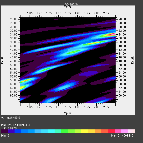
| Crust2 Type: | L8,thin continental arc, Cordilleras, 0.5 km seds. |
| Thickness Estimate: | 34 km |
| Thickness StdDev: | 14 km |
| Vp/Vs Estimate: | 2.10 |
| Vp/Vs StdDev: | 0.21 |
| Vs Estimate: | 3.13 km/s |
| Poisson's Ratio: | 0.35 |
| Peak Value: | 0.14 |
| Assumed Vp: | 6.566 km/s |
| Ps Weight: | 0.33333334 |
| PpPs Weight: | 0.33333334 |
| PsPs Weight: | 0.33333328 |
| Residual Complexity: | 0.675 |
| Nearby stations H: | +- |
| (2.0 deg) Vp/Vs: | +- |
0 with match > 90% ( 0.0 %) and 3 with match > 80% ( 15.789474 %) out of 19.
Download stack as xyz text file.
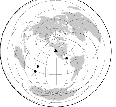
Azimuth Distribution of Events:
Prior Results for this Station
| Study | Thickness | Vp/Vs | Vp | Vs | Poissons Ratio | Extra |
| EARS | 34 km | 2.10 | 6.566 km/s | 3.13 km/s | 0.35 | |
| Crust2.0 | 34 km | 1.77 | 6.566 km/s | 3.707 km/s | 0.27 | L8,thin continental arc, Cordilleras, 0.5 km seds. |
| Global Maxima | 34 km | 2.10 | 6.566 km/s | 3.13 km/s | 0.35 | amp=0.14068885 |
| Local Maxima 1 | 58 km | 1.63 | 6.566 km/s | 4.035 km/s | 0.20 | amp=0.07931348 |
| Local Maxima 2 | 38 km | 1.99 | 6.566 km/s | 3.308 km/s | 0.33 | amp=0.07144631 |
| Local Maxima 3 | 52 km | 1.73 | 6.566 km/s | 3.79 km/s | 0.25 | amp=0.06666567 |
| Local Maxima 4 | 62 km | 1.83 | 6.566 km/s | 3.588 km/s | 0.29 | amp=0.0479344 |
| Predicted Arrivals for vertical incidence (zero ray parameter) | |
| Ps | 5.60 SECOND |
| PpPs | 15.80 SECOND |
| PsPs/PpSs | 21.40 SECOND |
Events Processed for this Station
Download zip of receiver functions as SAC
Plot maxima for each earthquake.
Events Used in the Stack
(3 events)| Radial Match | Distance | Baz | FERegion | Time | Lat/Lon | Depth | Magnitude |
| 88.85474 | 41.9 deg | 122.547 deg | North Of Honduras | 2009/05/28 08:24:45 GMT | (16.7, -86.2) | 10 km | 6.7 MB, 7.2 MS, 7.3 MW, 7.3 MW |
| 85.959076 | 76.1 deg | 229.654 deg | Samoa Islands Region | 2009/10/19 22:49:38 GMT | (-15.4, -172.3) | 18 km | 6.2 MB, 5.7 MS, 6.0 MW, 5.9 MW |
| 81.782974 | 92.7 deg | 225.537 deg | Kermadec Islands Region | 2009/05/16 00:53:52 GMT | (-31.5, -178.8) | 55 km | 6.1 MB, 6.5 MW, 6.3 MW |
Losers
(16 events)| Radial Match | Distance | Baz | FERegion | Time | Lat/Lon | Depth | Magnitude | Reason |
| 87.8768 | 50.8 deg | 306.488 deg | Kuril Islands | 2008/07/24 01:43:16 GMT | (51.0, 157.6) | 27 km | 6.0 MB, 6.0 MS, 6.2 MW, 6.2 MW | |
| 81.67787 | 69.7 deg | 300.213 deg | Near East Coast Of Honshu, Japan | 2009/06/06 05:52:43 GMT | (35.5, 140.9) | 34 km | 5.8 MB, 5.4 MS, 5.8 MW, 5.7 MW | |
| 80.21688 | 91.6 deg | 224.392 deg | Kermadec Islands Region | 2008/12/09 06:23:59 GMT | (-31.2, -176.9) | 18 km | 6.2 MB, 6.7 MS, 6.8 MW, 6.7 MW | |
| 79.49472 | 36.5 deg | 298.939 deg | Andreanof Islands, Aleutian Is. | 2009/06/22 19:55:24 GMT | (51.3, -178.2) | 35 km | 5.6 MB, 5.6 MW, 5.6 MW | |
| 78.39831 | 74.9 deg | 171.476 deg | Easter Island Region | 2008/08/19 10:58:00 GMT | (-28.5, -112.8) | 9.0 km | 5.5 MB, 5.3 MS, 5.7 MW, 5.7 MW | |
| 78.0576 | 35.9 deg | 19.335 deg | Baffin Bay | 2009/07/07 19:11:46 GMT | (75.4, -72.5) | 19 km | 5.9 MB, 5.7 MS, 6.1 MW, 6.0 MW | |
| 76.21666 | 89.8 deg | 330.823 deg | Qinghai, China | 2009/08/28 01:52:06 GMT | (37.7, 95.7) | 13 km | 6.2 MB, 6.2 MS, 6.2 MW, 6.2 MW | |
| 73.03498 | 77.8 deg | 284.839 deg | Mariana Islands | 2008/12/02 12:31:43 GMT | (19.1, 145.8) | 137 km | 5.9 MB, 5.9 MW, 5.9 MW | |
| 71.73939 | 40.9 deg | 130.285 deg | Guatemala | 2009/05/03 16:21:47 GMT | (14.6, -91.2) | 124 km | 5.6 MB, 6.2 MW, 6.2 MW | |
| 71.64555 | 88.6 deg | 243.664 deg | Vanuatu Islands | 2009/05/29 06:20:14 GMT | (-17.0, 168.3) | 13 km | 5.5 MB, 5.5 MS, 5.7 MW, 5.6 MW | |
| 65.96839 | 92.1 deg | 224.788 deg | Kermadec Islands Region | 2009/05/24 00:58:02 GMT | (-31.5, -177.7) | 4.0 km | 5.6 MB, 5.9 MS, 6.0 MW, 5.8 MW | |
| 59.780457 | 93.5 deg | 347.596 deg | Tajikistan-Xinjiang Border Reg. | 2008/10/05 16:11:10 GMT | (39.5, 73.9) | 35 km | 5.6 MB | |
| 56.53046 | 88.7 deg | 303.178 deg | Southwestern Ryukyu Isl., Japan | 2009/08/18 13:17:35 GMT | (23.5, 123.5) | 5.7 km | 5.6 MB, 5.2 MS | |
| 51.801006 | 86.0 deg | 248.113 deg | Santa Cruz Islands | 2009/10/07 22:26:38 GMT | (-12.1, 166.6) | 35 km | 5.6 MB | |
| 51.088062 | 85.6 deg | 231.529 deg | South Of Fiji Islands | 2009/06/08 04:33:19 GMT | (-22.2, -179.6) | 612 km | 5.5 MW, 5.2 MB | |
| 50.996006 | 77.0 deg | 230.446 deg | Tonga Islands | 2009/05/13 21:31:17 GMT | (-15.8, -173.5) | 85 km | 5.8 MW, 5.3 MB, 5.8 MW |
