
Station CD MDJ - Mudanjiang, Heilongjiang Province, China
Network: CD - China Digital Seismograph Network
Nearby stations (2 deg radius)
| Station | Name | (Lat, Lon) | Start / End | Elevation |
| MDJ | Mudanjiang, Heilongjiang Province, China | (44.62, 129.59) | 1986-10-18 / 1996-11-08 | 250 m |
| Crust2 Type: | G1,Archean, no seds. |
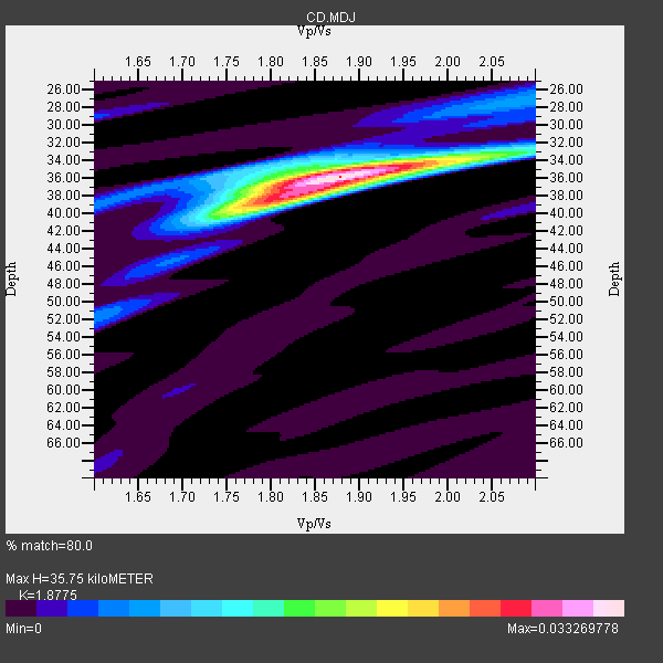
| Thickness Estimate: | 36 km |
| Thickness StdDev: | 1.0 km |
| Vp/Vs Estimate: | 1.88 |
| Vp/Vs StdDev: | 0.03 |
| Vs Estimate: | 3.44 km/s |
| Poisson's Ratio: | 0.30 |
| Peak Value: | 0.03 |
| Assumed Vp: | 6.459 km/s |
| Ps Weight: | 0.33333334 |
| PpPs Weight: | 0.33333334 |
| PsPs Weight: | 0.33333328 |
| Residual Complexity: | 0.465 |
| Nearby stations H: | 36 km +- 0.0 km |
| (2.0 deg) Vp/Vs: | 1.87 +- 0.02 |
10 with match > 90% ( 34.482758 %) and 19 with match > 80% ( 65.51724 %) out of 29.
Download stack as xyz text file.
Azimuth Distribution of Events:

Prior Results for this Station
| Study | Thickness | Vp/Vs | Vp | Vs | Poissons Ratio | Extra |
| EARS | 36 km | 1.88 | 6.459 km/s | 3.44 km/s | 0.30 | |
| Crust2.0 | 37 km | 1.76 | 6.459 km/s | 3.665 km/s | 0.26 | G1,Archean, no seds. |
| Zandt Ammon | 34 km | 1.76 | 6.0 km/s | 3.409 km/s | 0.26 | |
| Zandt Ammon | 35 km | 1.76 | 6.25 km/s | 3.551 km/s | 0.26 | |
| Zandt Ammon | 37 km | 1.75 | 6.5 km/s | 3.714 km/s | 0.26 | |
| Zandt Ammon | 38 km | 1.75 | 6.75 km/s | 3.857 km/s | 0.26 | |
| Global Maxima | 36 km | 1.88 | 6.459 km/s | 3.44 km/s | 0.30 | amp=0.033269778 |
| Local Maxima 1 | 38 km | 1.80 | 6.459 km/s | 3.594 km/s | 0.28 | amp=0.020930393 |
| Local Maxima 2 | 35 km | 1.76 | 6.459 km/s | 3.665 km/s | 0.26 | amp=0.009432332 |
| Local Maxima 3 | 33 km | 2.07 | 6.459 km/s | 3.121 km/s | 0.35 | amp=0.0076761963 |
| Local Maxima 4 | 27 km | 2.09 | 6.459 km/s | 3.094 km/s | 0.35 | amp=0.0068709916 |
| Predicted Arrivals for vertical incidence (zero ray parameter) | |
| Ps | 4.86 SECOND |
| PpPs | 15.93 SECOND |
| PsPs/PpSs | 20.78 SECOND |
Events Processed for this Station
Download zip of receiver functions as SAC
Plot maxima for each earthquake.
Events Used in the Stack
(19 events)| Radial Match | Distance | Baz | FERegion | Time | Lat/Lon | Depth | Magnitude |
| 96.278076 | 80.5 deg | 131.492 deg | Fiji Islands Region | 1996/08/05 22:38:22 GMT | (-20.7, -178.3) | 550 km | 6.4 MB, 7.4 UNKNOWN, 7.3 MW |
| 96.02992 | 51.6 deg | 181.262 deg | Banda Sea | 1993/01/20 17:31:15 GMT | (-7.2, 128.6) | 33 km | 6.0 MB, 6.3 MS |
| 95.95146 | 55.8 deg | 148.974 deg | Solomon Islands | 1996/04/29 14:40:41 GMT | (-6.5, 155.0) | 44 km | 6.3 MB, 7.5 MS, 7.2 UNKNOWN, 6.8 ME |
| 94.568886 | 77.7 deg | 130.206 deg | Fiji Islands Region | 1993/04/16 14:08:38 GMT | (-17.7, -178.9) | 568 km | 6.0 MB, 6.0 UNKNOWN |
| 94.042915 | 88.4 deg | 135.309 deg | Kermadec Islands Region | 1993/06/18 11:52:51 GMT | (-29.4, -176.7) | 21 km | 6.2 MB, 6.8 MS, 6.9 UNKNOWN, 6.8 MW |
| 93.71555 | 38.0 deg | 188.954 deg | Mindanao, Philippines | 1992/10/29 07:29:57 GMT | (6.8, 124.1) | 33 km | 5.5 MB, 5.9 MS |
| 92.64441 | 72.7 deg | 140.805 deg | Vanuatu Islands | 1994/02/11 21:17:31 GMT | (-18.8, 169.2) | 204 km | 6.3 MB, 7.0 UNKNOWN, 6.8 MW |
| 92.63332 | 33.1 deg | 186.638 deg | Samar, Philippines | 1995/05/08 18:08:09 GMT | (11.6, 125.9) | 33 km | 5.6 MB, 6.2 MS, 6.3 UNKNOWN, 6.3 MW |
| 92.47462 | 35.9 deg | 59.908 deg | Andreanof Islands, Aleutian Is. | 1996/06/10 15:36:29 GMT | (51.2, -176.8) | 33 km | 5.5 MB |
| 92.0587 | 31.9 deg | 188.388 deg | Samar, Philippines | 1996/06/14 15:04:40 GMT | (12.8, 125.1) | 29 km | 5.6 MB, 5.8 MS, 6.1 UNKNOWN, 5.9 MW |
| 88.63971 | 32.2 deg | 148.155 deg | Mariana Islands | 1993/06/06 13:23:27 GMT | (15.7, 146.6) | 68 km | 5.8 MB, 6.4 UNKNOWN |
| 88.087616 | 51.8 deg | 181.857 deg | Banda Sea | 1994/06/16 10:12:48 GMT | (-7.4, 128.1) | 119 km | 5.8 MB, 6.0 UNKNOWN, 5.9 MW |
| 87.94803 | 32.7 deg | 187.068 deg | Samar, Philippines | 1995/04/21 00:09:56 GMT | (12.0, 125.7) | 33 km | 6.1 MB, 6.9 MS, 6.9 UNKNOWN, 6.8 MW |
| 87.92694 | 45.8 deg | 183.031 deg | Halmahera, Indonesia | 1995/02/13 08:43:39 GMT | (-1.3, 127.4) | 33 km | 6.1 MB, 6.2 MS, 6.2 UNKNOWN, 6.2 MW |
| 85.78442 | 53.9 deg | 148.267 deg | Solomon Islands | 1996/05/02 13:34:28 GMT | (-4.5, 154.8) | 500 km | 5.6 MB, 6.6 UNKNOWN, 6.5 MW |
| 82.348656 | 81.3 deg | 133.715 deg | South Of Fiji Islands | 1996/08/27 06:24:07 GMT | (-22.6, -179.8) | 575 km | 5.6 MB, 6.0 UNKNOWN, 5.5 MB |
| 82.14453 | 34.9 deg | 185.486 deg | Mindanao, Philippines | 1996/11/04 12:53:36 GMT | (9.7, 126.4) | 33 km | 5.5 MS, 5.4 MB, 5.9 UNKNOWN, 5.8 MW |
| 81.457504 | 54.8 deg | 280.473 deg | Northern And Central Iran | 1994/02/24 00:11:12 GMT | (30.8, 60.5) | 13 km | 6.0 MB, 6.1 MS, 6.3 UNKNOWN, 6.1 MW |
| 81.045364 | 44.8 deg | 280.235 deg | Hindu Kush Region, Afghanistan | 1996/09/14 08:01:03 GMT | (36.0, 70.7) | 120 km | 5.8 UNKNOWN, 5.1 MB, 5.8 MW |
Losers
(10 events)| Radial Match | Distance | Baz | FERegion | Time | Lat/Lon | Depth | Magnitude | Reason |
| 79.74837 | 37.3 deg | 184.788 deg | Mindanao, Philippines | 1993/05/15 01:55:38 GMT | (7.2, 126.7) | 28 km | 5.5 MB, 5.2 MS | |
| 79.04648 | 88.3 deg | 135.704 deg | Kermadec Islands, New Zealand | 1993/09/12 08:22:34 GMT | (-29.5, -177.2) | 33 km | 5.5 MB, 5.8 MS, 6.0 UNKNOWN, 6.2 MW | |
| 74.765335 | 88.9 deg | 139.184 deg | South Of Kermadec Islands | 1994/12/27 17:32:52 GMT | (-32.0, 179.9) | 228 km | 6.0 MB, 6.1 UNKNOWN, 6.4 MW | |
| 74.52552 | 41.2 deg | 182.293 deg | North Of Halmahera, Indonesia | 1993/01/04 01:26:18 GMT | (3.3, 128.1) | 75 km | 5.7 MB | |
| 74.11939 | 78.1 deg | 130.093 deg | Fiji Islands Region | 1996/05/14 12:36:59 GMT | (-18.0, -178.5) | 605 km | 5.5 MB, 5.6 UNKNOWN | |
| 73.60796 | 53.7 deg | 152.112 deg | New Britain Region, P.N.G. | 1994/06/13 21:15:04 GMT | (-5.5, 151.9) | 31 km | 5.8 MB, 6.0 MS, 6.0 UNKNOWN, 6.2 MW | |
| 71.96816 | 72.4 deg | 47.589 deg | Oregon | 1993/09/21 03:28:55 GMT | (42.3, -122.0) | 11 km | 5.8 MB, 5.8 MS, 5.9 UNKNOWN, 5.9 ML | |
| 71.02169 | 68.3 deg | 140.475 deg | Vanuatu Islands | 1993/06/03 09:38:26 GMT | (-14.8, 167.3) | 153 km | 5.6 MB | |
| 67.359406 | 87.7 deg | 136.401 deg | Kermadec Islands, New Zealand | 1993/05/27 08:51:59 GMT | (-29.4, -178.3) | 121 km | 5.9 MB | |
| 61.108383 | 77.8 deg | 313.595 deg | Southern Italy | 1994/01/05 13:24:11 GMT | (39.2, 15.2) | 291 km | 5.9 MB, 6.0 UNKNOWN, 5.9 MW |
