
Station CI BCC - Bear Creek Country Club
Network: CI - Caltech Regional Seismic Network
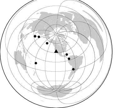
Nearby stations (2 deg radius)
| Station | Name | (Lat, Lon) | Start / End | Elevation |
| BCC | Bear Creek Country Club | (33.58, -117.26) | 2000-07-11 / 2005-08-08 | 391 m |
| Crust2 Type: | MG,very thin extended crust, 0.5 km seds. |
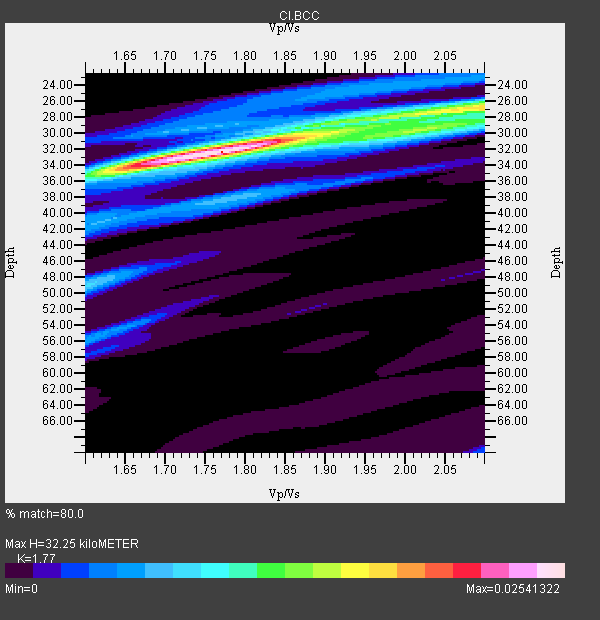
| Thickness Estimate: | 32 km |
| Thickness StdDev: | 4.8 km |
| Vp/Vs Estimate: | 1.77 |
| Vp/Vs StdDev: | 0.13 |
| Vs Estimate: | 3.539 km/s |
| Poisson's Ratio: | 0.27 |
| Peak Value: | 0.03 |
| Assumed Vp: | 6.264 km/s |
| Ps Weight: | 0.33333334 |
| PpPs Weight: | 0.33333334 |
| PsPs Weight: | 0.33333328 |
| Residual Complexity: | 0.573 |
| Nearby stations H: | +- |
| (2.0 deg) Vp/Vs: | +- |
5 with match > 90% ( 55.555557 %) and 8 with match > 80% ( 88.888885 %) out of 9.
Download stack as xyz text file.
Azimuth Distribution of Events:
Prior Results for this Station
| Study | Thickness | Vp/Vs | Vp | Vs | Poissons Ratio | Extra |
| EARS | 32 km | 1.77 | 6.264 km/s | 3.539 km/s | 0.27 | |
| Crust2.0 | 28 km | 1.78 | 6.264 km/s | 3.524 km/s | 0.27 | MG,very thin extended crust, 0.5 km seds. |
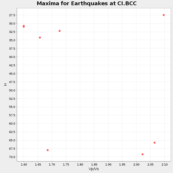
| Global Maxima | 32 km | 1.77 | 6.264 km/s | 3.539 km/s | 0.27 | amp=0.02541322 |
| Local Maxima 1 | 26 km | 2.10 | 6.264 km/s | 2.986 km/s | 0.35 | amp=0.016999815 |
| Local Maxima 2 | 30 km | 1.85 | 6.264 km/s | 3.381 km/s | 0.29 | amp=0.008265495 |
| Local Maxima 3 | 34 km | 1.64 | 6.264 km/s | 3.825 km/s | 0.20 | amp=0.0074055665 |
| Local Maxima 4 | 38 km | 1.79 | 6.264 km/s | 3.504 km/s | 0.27 | amp=0.00689374 |
| Predicted Arrivals for vertical incidence (zero ray parameter) | |
| Ps | 3.96 SECOND |
| PpPs | 14.26 SECOND |
| PsPs/PpSs | 18.23 SECOND |
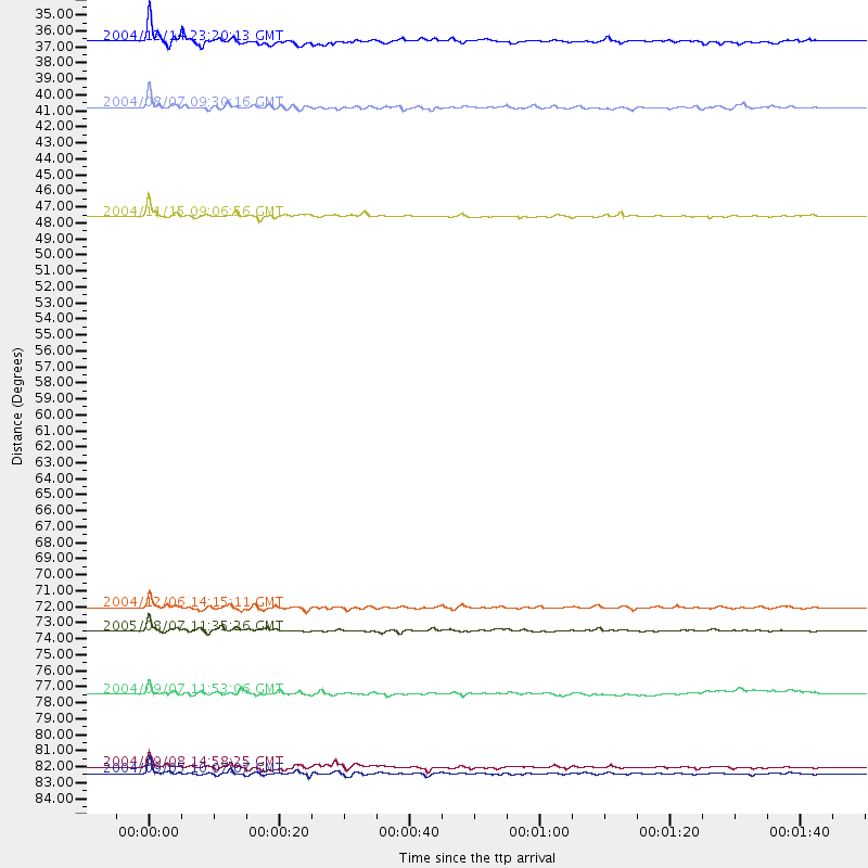
Events Processed for this Station
Download zip of receiver functions as SAC
Plot maxima for each earthquake.
Events Used in the Stack
(8 events)| Radial Match | Distance | Baz | FERegion | Time | Lat/Lon | Depth | Magnitude |
| 95.23474 | 84.0 deg | 305.798 deg | Near S. Coast Of Western Honshu | 2004/09/05 10:07:07 GMT | (33.1, 136.6) | 14 km | 6.7 MB, 7.0 MS, 7.2 MW, 7.0 MW |
| 94.502045 | 46.8 deg | 119.042 deg | Near West Coast Of Colombia | 2004/11/15 09:06:56 GMT | (4.7, -77.5) | 15 km | 6.6 MB, 7.1 MS, 7.2 MW, 7.1 MW |
| 93.24636 | 39.5 deg | 312.466 deg | South Of Aleutian Islands | 2004/08/07 09:30:16 GMT | (51.8, -166.3) | 8.0 km | 6.3 MB, 5.4 MS, 6.0 MW, 6.0 MW |
| 92.303986 | 35.1 deg | 105.397 deg | Caribbean Sea | 2004/12/14 23:20:13 GMT | (19.0, -81.4) | 10 km | 6.2 MB, 6.7 MS, 6.8 MW, 6.8 MW |
| 92.22306 | 74.5 deg | 240.575 deg | Fiji Islands Region | 2005/08/07 11:35:26 GMT | (-14.4, -177.3) | 10 km | 5.7 MB, 5.9 MS, 6.0 MW, 6.0 MW |
| 87.156265 | 83.6 deg | 305.566 deg | Near S. Coast Of Honshu, Japan | 2004/09/08 14:58:25 GMT | (33.1, 137.2) | 21 km | 6.2 MB, 5.8 MS, 6.2 MW, 6.1 MW |
| 86.53609 | 73.0 deg | 310.36 deg | Hokkaido, Japan Region | 2004/12/06 14:15:11 GMT | (42.9, 145.2) | 35 km | 6.5 MB, 6.5 MS, 6.8 MW, 6.8 MW |
| 86.49512 | 78.7 deg | 135.477 deg | Santiago Del Estero Prov., Arg. | 2004/09/07 11:53:06 GMT | (-28.6, -65.8) | 22 km | 6.1 MB, 6.1 MS, 6.4 MW, 6.2 MW |
Losers
(1 events)| Radial Match | Distance | Baz | FERegion | Time | Lat/Lon | Depth | Magnitude | Reason |
| 91.34947 | 77.5 deg | 238.99 deg | Fiji Islands Region | 2004/07/15 04:27:12 GMT | (-17.6, -178.6) | 560 km | 5.5 MB |
