
Station CI SDP - Sudden Peak, Lompoc, CA, USA
Network: CI - Caltech Regional Seismic Network
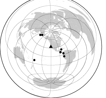
Nearby stations (2 deg radius)
| Station | Name | (Lat, Lon) | Start / End | Elevation |
| SDP | Sudden Peak, Lompoc, CA, USA | (34.57, -120.50) | 2002-01-18 / 2499-01-01 | 0.6 km |
| Crust2 Type: | S1,continental slope, margin, transition 1 km seds. |
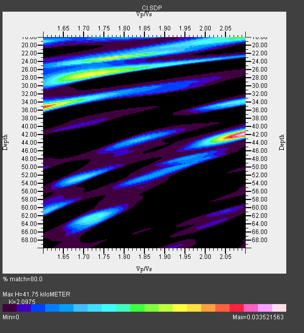
| Thickness Estimate: | 42 km |
| Thickness StdDev: | 12 km |
| Vp/Vs Estimate: | 2.10 |
| Vp/Vs StdDev: | 0.21 |
| Vs Estimate: | 2.948 km/s |
| Poisson's Ratio: | 0.35 |
| Peak Value: | 0.03 |
| Assumed Vp: | 6.183 km/s |
| Ps Weight: | 0.33333334 |
| PpPs Weight: | 0.33333334 |
| PsPs Weight: | 0.33333328 |
| Residual Complexity: | 0.886 |
| Nearby stations H: | +- |
| (2.0 deg) Vp/Vs: | +- |
5 with match > 90% ( 55.555557 %) and 8 with match > 80% ( 88.888885 %) out of 9.
Download stack as xyz text file.
Azimuth Distribution of Events:
Prior Results for this Station
| Study | Thickness | Vp/Vs | Vp | Vs | Poissons Ratio | Extra |
| EARS | 42 km | 2.10 | 6.183 km/s | 2.948 km/s | 0.35 | |
| Crust2.0 | 23 km | 1.81 | 6.183 km/s | 3.422 km/s | 0.28 | S1,continental slope, margin, transition 1 km seds. |
| Global Maxima | 42 km | 2.10 | 6.183 km/s | 2.948 km/s | 0.35 | amp=0.033521563 |
| Local Maxima 1 | 35 km | 1.60 | 6.183 km/s | 3.864 km/s | 0.18 | amp=0.027495079 |
| Local Maxima 2 | 23 km | 1.79 | 6.183 km/s | 3.454 km/s | 0.27 | amp=0.022341581 |
| Local Maxima 3 | 27 km | 1.73 | 6.183 km/s | 3.579 km/s | 0.25 | amp=0.019424736 |
| Local Maxima 4 | 18 km | 2.09 | 6.183 km/s | 2.955 km/s | 0.35 | amp=0.014250792 |
| Predicted Arrivals for vertical incidence (zero ray parameter) | |
| Ps | 7.41 SECOND |
| PpPs | 20.92 SECOND |
| PsPs/PpSs | 28.33 SECOND |
Events Processed for this Station
Download zip of receiver functions as SAC
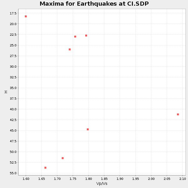
Plot maxima for each earthquake.
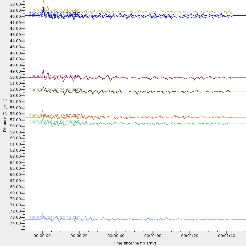
Events Used in the Stack
(8 events)| Radial Match | Distance | Baz | FERegion | Time | Lat/Lon | Depth | Magnitude |
| 93.58186 | 37.9 deg | 103.96 deg | Caribbean Sea | 2004/12/14 23:20:13 GMT | (19.0, -81.4) | 10 km | 6.2 MB, 6.7 MS, 6.8 MW, 6.8 MW |
| 93.437096 | 74.6 deg | 231.677 deg | Tonga Islands | 2006/05/03 15:26:40 GMT | (-20.2, -174.1) | 55 km | 7.2 MB, 7.8 MS, 7.9 MW, 7.9 MW |
| 93.054436 | 49.6 deg | 116.887 deg | Near West Coast Of Colombia | 2004/11/15 09:06:56 GMT | (4.7, -77.5) | 15 km | 6.6 MB, 7.1 MS, 7.2 MW, 7.1 MW |
| 92.32873 | 57.7 deg | 124.985 deg | Northern Peru | 2005/09/26 01:55:37 GMT | (-5.7, -76.4) | 115 km | 6.7 MB, 7.5 MW, 7.5 MW |
| 91.49047 | 52.1 deg | 323.855 deg | Eastern Siberia, Russia | 2006/04/20 23:25:02 GMT | (60.9, 167.1) | 22 km | 6.8 MB, 7.6 MS, 7.6 MW, 7.3 MW |
| 87.01572 | 56.6 deg | 318.154 deg | Kamchatka Peninsula, Russia | 2004/06/10 15:19:57 GMT | (55.7, 160.0) | 189 km | 6.1 MB, 6.9 MW, 6.9 MW |
| 84.99193 | 38.6 deg | 119.798 deg | Off Coast Of Costa Rica | 2004/06/29 07:01:30 GMT | (10.7, -87.0) | 9.0 km | 5.8 MB, 5.8 MS, 6.3 MW, 6.1 MW |
| 83.218376 | 38.9 deg | 118.28 deg | Near Coast Of Nicaragua | 2005/07/02 02:16:43 GMT | (11.2, -86.2) | 27 km | 5.6 MB, 6.4 MS, 6.6 MW, 6.6 MW |
Losers
(1 events)| Radial Match | Distance | Baz | FERegion | Time | Lat/Lon | Depth | Magnitude | Reason |
| 83.589386 | 75.8 deg | 236.645 deg | Fiji Islands Region | 2004/07/15 04:27:12 GMT | (-17.6, -178.6) | 560 km | 5.5 MB |
