
Station CN BATG - Bathurst, NB, CA
Network: CN - Canadian National Seismograph Network
Nearby stations (2 deg radius)
| Station | Name | (Lat, Lon) | Start / End | Elevation |
| BATG | Bathurst, NB, CA | (47.28, -66.06) | 2005-10-22 / 2017-09-26 | 336 m |
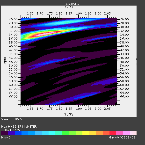
| Crust2 Type: | Q2,orogen/39km no ice, Appalachians, North Andes, 0.5 km seds. |
| Thickness Estimate: | 33 km |
| Thickness StdDev: | 9.2 km |
| Vp/Vs Estimate: | 1.73 |
| Vp/Vs StdDev: | 0.08 |
| Vs Estimate: | 3.716 km/s |
| Poisson's Ratio: | 0.25 |
| Peak Value: | 0.05 |
| Assumed Vp: | 6.419 km/s |
| Ps Weight: | 0.33333334 |
| PpPs Weight: | 0.33333334 |
| PsPs Weight: | 0.33333328 |
| Residual Complexity: | 0.416 |
| Nearby stations H: | +- |
| (2.0 deg) Vp/Vs: | +- |
0 with match > 90% ( 0.0 %) and 4 with match > 80% ( 11.764706 %) out of 34.
Download stack as xyz text file.
Azimuth Distribution of Events:

Prior Results for this Station
| Study | Thickness | Vp/Vs | Vp | Vs | Poissons Ratio | Extra |
| EARS | 33 km | 1.73 | 6.419 km/s | 3.716 km/s | 0.25 | |
| Crust2.0 | 39 km | 1.75 | 6.419 km/s | 3.659 km/s | 0.26 | Q2,orogen/39km no ice, Appalachians, North Andes, 0.5 km seds. |
| Global Maxima | 33 km | 1.73 | 6.419 km/s | 3.716 km/s | 0.25 | amp=0.05213402 |
| Local Maxima 1 | 27 km | 1.84 | 6.419 km/s | 3.493 km/s | 0.29 | amp=0.020061458 |
| Local Maxima 2 | 36 km | 1.64 | 6.419 km/s | 3.92 km/s | 0.20 | amp=0.016874084 |
| Local Maxima 3 | 33 km | 1.68 | 6.419 km/s | 3.827 km/s | 0.22 | amp=0.013628784 |
| Local Maxima 4 | 26 km | 1.62 | 6.419 km/s | 3.95 km/s | 0.20 | amp=0.01141472 |
| Predicted Arrivals for vertical incidence (zero ray parameter) | |
| Ps | 3.77 SECOND |
| PpPs | 14.13 SECOND |
| PsPs/PpSs | 17.90 SECOND |
Events Processed for this Station
Download zip of receiver functions as SAC
Plot maxima for each earthquake.
Events Used in the Stack
(4 events)| Radial Match | Distance | Baz | FERegion | Time | Lat/Lon | Depth | Magnitude |
| 89.16983 | 39.7 deg | 218.35 deg | Off Coast Of Central America | 2017/05/12 10:41:26 GMT | (12.9, -90.1) | 10 km | 6.2 Mww |
| 87.83267 | 68.1 deg | 327.796 deg | Near Islands, Aleutian Islands | 2017/06/02 22:24:47 GMT | (54.0, 170.9) | 8.2 km | 6.8 Mww |
| 86.3196 | 66.3 deg | 177.77 deg | Southern Bolivia | 2017/02/21 14:09:04 GMT | (-19.3, -63.9) | 598 km | 6.5 Mww |
| 84.47238 | 68.5 deg | 333.678 deg | Near East Coast Of Kamchatka | 2017/03/29 04:09:24 GMT | (56.9, 162.7) | 23 km | 6.6 Mww |
Losers
(30 events)| Radial Match | Distance | Baz | FERegion | Time | Lat/Lon | Depth | Magnitude | Reason |
| 93.37911 | 38.8 deg | 222.426 deg | Near Coast Of Chiapas, Mexico | 2017/06/14 07:29:03 GMT | (14.9, -92.0) | 98 km | 7.0 Mi | |
| 90.681755 | 39.5 deg | 220.324 deg | Near Coast Of Guatemala | 2017/06/22 12:31:04 GMT | (13.7, -91.1) | 10 km | 6.8 Mi | |
| 90.59636 | 80.1 deg | 185.065 deg | Off Coast Of Central Chile | 2017/04/24 21:38:24 GMT | (-33.0, -72.0) | 33 km | 6.7 Mi | |
| 85.73387 | 41.7 deg | 314.327 deg | Southeastern Alaska | 2017/05/01 12:31:53 GMT | (59.9, -136.6) | 0.1 km | 6.5 Ml | |
| 75.78195 | 41.7 deg | 314.312 deg | Southeastern Alaska | 2017/05/01 14:18:15 GMT | (59.8, -136.6) | 3.3 km | 6.3 Ml | |
| 75.7692 | 70.2 deg | 181.557 deg | Chile-Argentina Border Region | 2017/04/15 08:19:41 GMT | (-23.2, -67.7) | 135 km | 6.2 Mww | |
| 75.62658 | 64.2 deg | 59.978 deg | Aegean Sea | 2017/06/12 12:28:38 GMT | (38.9, 26.4) | 10 km | 6.3 Mww | |
| 66.40684 | 84.4 deg | 41.043 deg | Northern And Central Iran | 2017/04/05 06:09:12 GMT | (35.8, 60.4) | 13 km | 6.1 Mww | |
| 64.19853 | 78.6 deg | 184.967 deg | Near Coast Of Central Chile | 2017/06/12 02:43:26 GMT | (-31.5, -71.8) | 26 km | 5.6 Mww | |
| 60.40686 | 68.6 deg | 326.323 deg | Near Islands, Aleutian Islands | 2017/03/27 10:50:19 GMT | (52.8, 172.2) | 10 km | 6.1 Mww | |
| 58.42399 | 49.1 deg | 199.282 deg | Near Coast Of Ecuador | 2017/06/30 22:29:44 GMT | (-0.3, -80.5) | 7.4 km | 6.0 Mww | |
| 57.47594 | 30.0 deg | 170.573 deg | Leeward Islands | 2017/04/17 05:23:15 GMT | (17.5, -61.1) | 21 km | 5.6 Mww | |
| 57.08722 | 54.0 deg | 63.688 deg | Central Italy | 2017/01/18 10:25:25 GMT | (42.6, 13.2) | 10 km | 5.6 Mww | |
| 56.916363 | 59.9 deg | 315.901 deg | Fox Islands, Aleutian Islands | 2017/05/24 16:36:01 GMT | (52.4, -166.7) | 2.0 km | 5.7 Mi | |
| 53.751442 | 83.7 deg | 335.712 deg | Kuril Islands | 2017/04/20 11:41:26 GMT | (44.4, 148.7) | 61 km | 5.5 mb | |
| 53.06209 | 92.6 deg | 190.536 deg | Off Coast Of Southern Chile | 2017/02/28 17:35:40 GMT | (-44.8, -80.9) | 10 km | 5.6 Mww | |
| 49.63582 | 50.5 deg | 192.012 deg | Peru-Ecuador Border Region | 2017/04/18 17:49:55 GMT | (-2.7, -75.3) | 11 km | 6.0 Mww | |
| 46.770164 | 85.7 deg | 31.624 deg | Tajikistan | 2017/05/05 05:09:35 GMT | (39.5, 71.4) | 10 km | 5.8 Mww | |
| 45.952557 | 62.8 deg | 188.017 deg | Southern Peru | 2017/06/24 16:09:11 GMT | (-15.5, -73.5) | 69 km | 5.7 Mww | |
| 44.165737 | 80.2 deg | 184.907 deg | Near Coast Of Central Chile | 2017/04/28 16:05:55 GMT | (-33.1, -71.8) | 14 km | 5.7 Mww | |
| 42.246376 | 39.9 deg | 212.633 deg | Near Coast Of Nicaragua | 2017/06/17 13:47:38 GMT | (11.3, -86.7) | 28 km | 5.4 Mww | |
| 37.64692 | 52.7 deg | 192.913 deg | Northern Peru | 2017/01/02 13:13:48 GMT | (-4.9, -76.3) | 108 km | 5.9 Mwb | |
| 36.518986 | 35.3 deg | 185.981 deg | Near Coast Of Venezuela | 2017/03/10 13:46:39 GMT | (12.0, -69.6) | 10 km | 5.5 mb | |
| 36.12567 | 80.3 deg | 185.044 deg | Near Coast Of Central Chile | 2017/04/28 15:30:05 GMT | (-33.2, -72.0) | 20 km | 5.9 Mww | |
| 26.620293 | 75.4 deg | 333.291 deg | Kuril Islands | 2017/06/03 11:47:23 GMT | (50.9, 157.3) | 44 km | 5.1 Mww | |
| 25.745676 | 40.9 deg | 229.394 deg | Near Coast Of Oaxaca, Mexico | 2017/06/14 23:58:52 GMT | (15.4, -97.1) | 6.9 km | 5.5 Mww | |
| 24.122068 | 81.3 deg | 41.998 deg | Turkmenistan-Iran Border Region | 2017/05/13 18:01:01 GMT | (37.9, 57.3) | 12 km | 5.8 Mww | |
| 11.4778185 | 84.4 deg | 336.192 deg | Kuril Islands | 2017/05/22 11:00:57 GMT | (43.9, 147.7) | 54 km | 5.5 Mww | |
| 9.536069 | 69.9 deg | 183.79 deg | Northern Chile | 2017/01/11 21:58:17 GMT | (-22.8, -69.9) | 69 km | 5.9 Mww | |
| 8.783093 | 67.3 deg | 321.982 deg | Rat Islands, Aleutian Islands | 2017/04/27 14:46:33 GMT | (51.3, 178.6) | 19 km | 5.7 Mww |

