
Station CN BSCQ - Baie-Sainte-Catherine, QC, CA
Network: CN - Canadian National Seismograph Network
Nearby stations (2 deg radius)
| Station | Name | (Lat, Lon) | Start / End | Elevation |
| BSCQ | Baie-Sainte-Catherine, QC, CA | (48.12, -69.72) | 2015-10-20 / 2599-12-31 | 2.0 m |
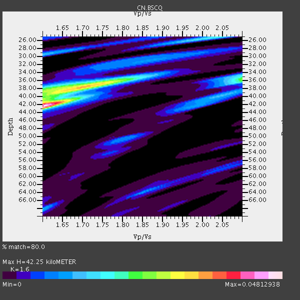
| Crust2 Type: | P6,orogen/43km, Orogen, 0.5 km seds. |
| Thickness Estimate: | 42 km |
| Thickness StdDev: | 7.7 km |
| Vp/Vs Estimate: | 1.60 |
| Vp/Vs StdDev: | 0.04 |
| Vs Estimate: | 3.969 km/s |
| Poisson's Ratio: | 0.18 |
| Peak Value: | 0.05 |
| Assumed Vp: | 6.35 km/s |
| Ps Weight: | 0.33333334 |
| PpPs Weight: | 0.33333334 |
| PsPs Weight: | 0.33333328 |
| Residual Complexity: | 0.733 |
| Nearby stations H: | +- |
| (2.0 deg) Vp/Vs: | +- |
3 with match > 90% ( 27.272728 %) and 4 with match > 80% ( 36.363636 %) out of 11.
Download stack as xyz text file.
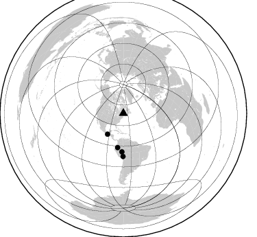
Azimuth Distribution of Events:
Prior Results for this Station
| Study | Thickness | Vp/Vs | Vp | Vs | Poissons Ratio | Extra |
| EARS | 42 km | 1.60 | 6.35 km/s | 3.969 km/s | 0.18 | |
| Crust2.0 | 43 km | 1.76 | 6.35 km/s | 3.609 km/s | 0.26 | P6,orogen/43km, Orogen, 0.5 km seds. |
| Global Maxima | 42 km | 1.60 | 6.35 km/s | 3.969 km/s | 0.18 | amp=0.04812938 |
| Local Maxima 1 | 37 km | 1.73 | 6.35 km/s | 3.671 km/s | 0.25 | amp=0.03174844 |
| Local Maxima 2 | 36 km | 2.09 | 6.35 km/s | 3.046 km/s | 0.35 | amp=0.017268568 |
| Local Maxima 3 | 40 km | 1.60 | 6.35 km/s | 3.969 km/s | 0.18 | amp=0.015575814 |
| Local Maxima 4 | 29 km | 1.61 | 6.35 km/s | 3.95 km/s | 0.18 | amp=0.012740613 |
| Predicted Arrivals for vertical incidence (zero ray parameter) | |
| Ps | 3.99 SECOND |
| PpPs | 17.30 SECOND |
| PsPs/PpSs | 21.29 SECOND |
Events Processed for this Station
Download zip of receiver functions as SAC
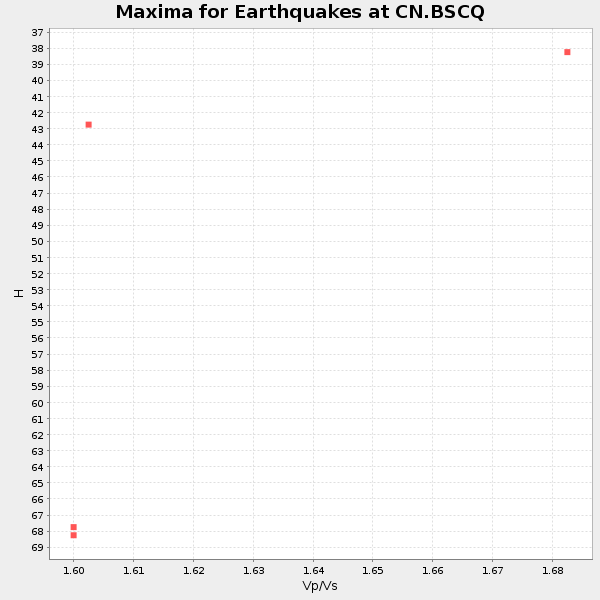
Plot maxima for each earthquake.
Events Used in the Stack
(4 events)| Radial Match | Distance | Baz | FERegion | Time | Lat/Lon | Depth | Magnitude |
| 98.72042 | 50.5 deg | 189.477 deg | Peru-Ecuador Border Region | 2019/02/22 10:17:22 GMT | (-2.2, -77.0) | 132 km | 7.5 mww |
| 96.03373 | 38.1 deg | 216.974 deg | Near Coast Of Chiapas, Mexico | 2019/02/01 16:14:13 GMT | (14.8, -92.3) | 68 km | 6.6 Mww |
| 92.18685 | 62.5 deg | 180.448 deg | Central Peru | 2019/03/01 08:50:41 GMT | (-14.7, -70.1) | 257 km | 7.0 mww |
| 88.68229 | 56.0 deg | 182.217 deg | Western Brazil | 2019/01/05 19:25:38 GMT | (-8.1, -71.6) | 575 km | 6.8 Mww |
Losers
(7 events)| Radial Match | Distance | Baz | FERegion | Time | Lat/Lon | Depth | Magnitude | Reason |
| 77.22786 | 52.7 deg | 185.371 deg | Peru-Brazil Border Region | 2019/01/08 10:00:09 GMT | (-4.6, -74.0) | 10 km | 5.1 Mww | |
| 77.16628 | 77.9 deg | 181.514 deg | Near Coast Of Central Chile | 2019/01/20 01:32:51 GMT | (-30.1, -71.4) | 53 km | 6.7 mww | |
| 61.958214 | 63.9 deg | 318.11 deg | Andreanof Islands, Aleutian Is. | 2019/01/05 18:47:11 GMT | (51.0, -178.2) | 35 km | 6.0 Mi | |
| 60.322205 | 84.7 deg | 333.417 deg | Off Coast Of Hokkaido, Japan | 2019/03/02 03:22:52 GMT | (41.9, 146.9) | 10 km | 6.0 Mww | |
| 59.009373 | 51.6 deg | 189.105 deg | Northern Peru | 2019/01/18 21:27:01 GMT | (-3.3, -76.9) | 103 km | 5.7 Mww | |
| 56.038136 | 45.3 deg | 188.525 deg | Colombia | 2019/01/26 12:32:27 GMT | (3.0, -75.8) | 10 km | 5.6 Mww | |
| 41.247616 | 45.2 deg | 188.432 deg | Colombia | 2019/01/28 21:07:10 GMT | (3.1, -75.7) | 15 km | 5.5 Mww |

