
Station CN FNBB - Fort Nelson, BC, CA
Network: CN - Canadian National Seismograph Network
Nearby stations (2 deg radius)
| Station | Name | (Lat, Lon) | Start / End | Elevation |
| FNBB | Fort Nelson, BC, CA | (58.89, -123.01) | 1999-10-24 / 2017-09-02 | 618 m |
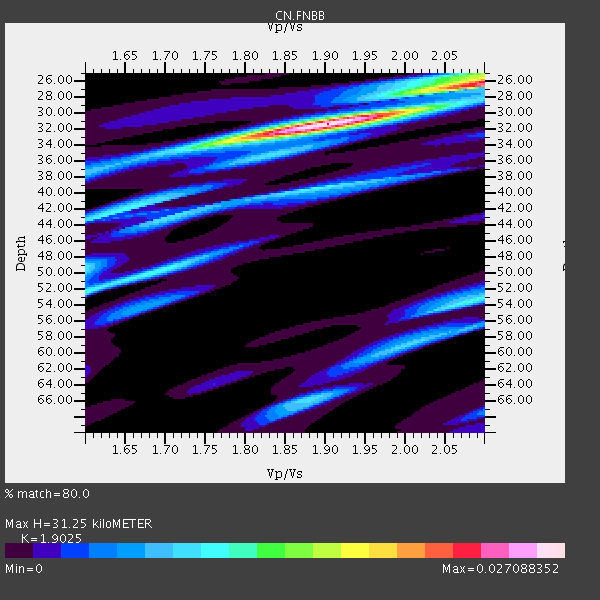
| Crust2 Type: | Q3,orogen/43km no ice, Appalachians, 3 km seds. |
| Thickness Estimate: | 31 km |
| Thickness StdDev: | 12 km |
| Vp/Vs Estimate: | 1.90 |
| Vp/Vs StdDev: | 0.14 |
| Vs Estimate: | 3.307 km/s |
| Poisson's Ratio: | 0.31 |
| Peak Value: | 0.03 |
| Assumed Vp: | 6.291 km/s |
| Ps Weight: | 0.33333334 |
| PpPs Weight: | 0.33333334 |
| PsPs Weight: | 0.33333328 |
| Residual Complexity: | 0.568 |
| Nearby stations H: | +- |
| (2.0 deg) Vp/Vs: | +- |
2 with match > 90% ( 16.666666 %) and 3 with match > 80% ( 25.0 %) out of 12.
Download stack as xyz text file.
Azimuth Distribution of Events:

Prior Results for this Station
| Study | Thickness | Vp/Vs | Vp | Vs | Poissons Ratio | Extra |
| EARS | 31 km | 1.90 | 6.291 km/s | 3.307 km/s | 0.31 | |
| Crust2.0 | 43 km | 1.76 | 6.291 km/s | 3.577 km/s | 0.26 | Q3,orogen/43km no ice, Appalachians, 3 km seds. |
| Global Maxima | 31 km | 1.90 | 6.291 km/s | 3.307 km/s | 0.31 | amp=0.027088352 |
| Local Maxima 1 | 26 km | 2.10 | 6.291 km/s | 2.999 km/s | 0.35 | amp=0.020070398 |
| Local Maxima 2 | 53 km | 2.09 | 6.291 km/s | 3.017 km/s | 0.35 | amp=0.011196398 |
| Local Maxima 3 | 52 km | 1.60 | 6.291 km/s | 3.932 km/s | 0.18 | amp=0.011060656 |
| Local Maxima 4 | 39 km | 1.89 | 6.291 km/s | 3.333 km/s | 0.30 | amp=0.010125707 |
| Predicted Arrivals for vertical incidence (zero ray parameter) | |
| Ps | 4.48 SECOND |
| PpPs | 14.42 SECOND |
| PsPs/PpSs | 18.90 SECOND |
Events Processed for this Station
Download zip of receiver functions as SAC
Plot maxima for each earthquake.
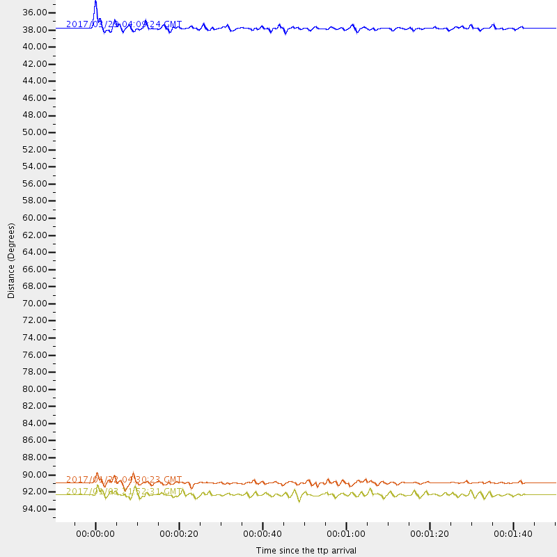
Events Used in the Stack
(3 events)| Radial Match | Distance | Baz | FERegion | Time | Lat/Lon | Depth | Magnitude |
| 94.28695 | 91.1 deg | 259.86 deg | Solomon Islands | 2017/01/22 04:30:23 GMT | (-6.2, 155.1) | 136 km | 7.9 mww |
| 90.530106 | 37.6 deg | 300.187 deg | Near East Coast Of Kamchatka | 2017/03/29 04:09:24 GMT | (56.9, 162.7) | 23 km | 6.6 Mww |
| 81.00521 | 92.5 deg | 235.711 deg | South Of Fiji Islands | 2017/01/03 21:52:31 GMT | (-19.3, 176.1) | 17 km | 6.9 Mww |
Losers
(9 events)| Radial Match | Distance | Baz | FERegion | Time | Lat/Lon | Depth | Magnitude | Reason |
| 76.052475 | 35.6 deg | 289.219 deg | Near Islands, Aleutian Islands | 2017/03/27 10:50:19 GMT | (52.8, 172.2) | 10 km | 6.1 Mww | |
| 70.39886 | 91.6 deg | 125.812 deg | Southern Bolivia | 2017/02/21 14:09:04 GMT | (-19.3, -63.9) | 598 km | 6.5 Mww | |
| 63.384888 | 89.0 deg | 231.631 deg | Fiji Islands Region | 2017/02/24 23:46:45 GMT | (-18.0, -178.5) | 581 km | 5.9 Mww | |
| 59.92165 | 73.6 deg | 130.922 deg | Northern Peru | 2017/01/02 13:13:48 GMT | (-4.9, -76.3) | 108 km | 5.9 Mwb | |
| 59.871616 | 92.4 deg | 132.409 deg | Northern Chile | 2017/01/11 21:58:17 GMT | (-22.8, -69.9) | 69 km | 5.9 Mww | |
| 54.368774 | 61.4 deg | 116.484 deg | Near Coast Of Venezuela | 2017/03/10 13:46:39 GMT | (12.0, -69.6) | 10 km | 5.5 mb | |
| 50.880627 | 93.4 deg | 227.827 deg | South Of Fiji Islands | 2017/03/17 10:18:39 GMT | (-23.6, -176.8) | 109 km | 5.5 mb | |
| 46.45421 | 61.8 deg | 295.5 deg | Near East Coast Of Honshu, Japan | 2017/01/04 17:53:20 GMT | (37.1, 141.3) | 10 km | 5.6 mb | |
| 38.229507 | 61.4 deg | 295.819 deg | Near East Coast Of Honshu, Japan | 2017/02/28 07:49:01 GMT | (37.6, 141.3) | 38 km | 5.7 Mww |

