
Station CN PCAQ - Pointe Carleton Anticosti, QC, CA
Network: CN - Canadian National Seismograph Network
Nearby stations (2 deg radius)

| Station | Name | (Lat, Lon) | Start / End | Elevation |
| PCAQ | Pointe Carleton Anticosti, QC, CA | (49.73, -62.94) | 2015-09-17 / 2599-12-31 | 15 m |
| Crust2 Type: | Q3,orogen/43km no ice, Appalachians, 3 km seds. |
| Thickness Estimate: | 36 km |
| Thickness StdDev: | 3.0 km |
| Vp/Vs Estimate: | 2.02 |
| Vp/Vs StdDev: | 0.07 |
| Vs Estimate: | 3.114 km/s |
| Poisson's Ratio: | 0.34 |
| Peak Value: | 0.04 |
| Assumed Vp: | 6.291 km/s |
| Ps Weight: | 0.33333334 |
| PpPs Weight: | 0.33333334 |
| PsPs Weight: | 0.33333328 |
| Residual Complexity: | 0.412 |
| Nearby stations H: | +- |
| (2.0 deg) Vp/Vs: | +- |
2 with match > 90% ( 22.222221 %) and 4 with match > 80% ( 44.444443 %) out of 9.
Download stack as xyz text file.
Azimuth Distribution of Events:
Prior Results for this Station
| Study | Thickness | Vp/Vs | Vp | Vs | Poissons Ratio | Extra |
| EARS | 36 km | 2.02 | 6.291 km/s | 3.114 km/s | 0.34 | |
| Crust2.0 | 43 km | 1.76 | 6.291 km/s | 3.577 km/s | 0.26 | Q3,orogen/43km no ice, Appalachians, 3 km seds. |
| Global Maxima | 36 km | 2.02 | 6.291 km/s | 3.114 km/s | 0.34 | amp=0.04346806 |
| Local Maxima 1 | 28 km | 2.10 | 6.291 km/s | 2.999 km/s | 0.35 | amp=0.015135006 |
| Local Maxima 2 | 49 km | 1.75 | 6.291 km/s | 3.605 km/s | 0.26 | amp=0.012735238 |
| Local Maxima 3 | 39 km | 1.98 | 6.291 km/s | 3.173 km/s | 0.33 | amp=0.010073266 |
| Local Maxima 4 | 38 km | 1.88 | 6.291 km/s | 3.346 km/s | 0.30 | amp=0.009286866 |
| Predicted Arrivals for vertical incidence (zero ray parameter) | |
| Ps | 5.76 SECOND |
| PpPs | 17.04 SECOND |
| PsPs/PpSs | 22.80 SECOND |
Events Processed for this Station
Download zip of receiver functions as SAC
Plot maxima for each earthquake.
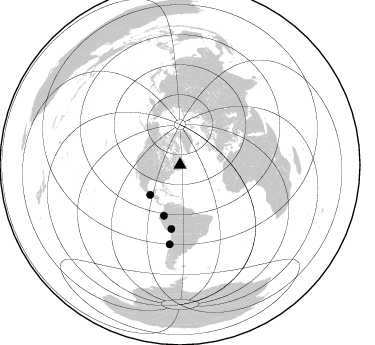
Events Used in the Stack
(4 events)| Radial Match | Distance | Baz | FERegion | Time | Lat/Lon | Depth | Magnitude |
| 98.0538 | 53.1 deg | 197.691 deg | Peru-Ecuador Border Region | 2019/02/22 10:17:22 GMT | (-2.2, -77.0) | 132 km | 7.5 mww |
| 90.92098 | 64.4 deg | 187.71 deg | Central Peru | 2019/03/01 08:50:41 GMT | (-14.7, -70.1) | 257 km | 7.0 mww |
| 84.05934 | 42.3 deg | 224.821 deg | Near Coast Of Chiapas, Mexico | 2019/02/01 16:14:13 GMT | (14.8, -92.3) | 68 km | 6.6 Mww |
| 81.086235 | 79.8 deg | 187.464 deg | Near Coast Of Central Chile | 2019/01/20 01:32:51 GMT | (-30.1, -71.4) | 53 km | 6.7 mww |
Losers
(5 events)| Radial Match | Distance | Baz | FERegion | Time | Lat/Lon | Depth | Magnitude | Reason |
| 73.11567 | 53.4 deg | 233.28 deg | Northern East Pacific Rise | 2019/01/18 16:40:42 GMT | (8.3, -103.5) | 10 km | 6.0 Mww | |
| 65.95209 | 47.8 deg | 197.406 deg | Colombia | 2019/01/26 12:32:27 GMT | (3.0, -75.8) | 10 km | 5.6 Mww | |
| 47.4928 | 82.5 deg | 337.708 deg | Kuril Islands | 2018/12/28 13:03:33 GMT | (44.2, 148.6) | 49 km | 5.5 mb | |
| 38.518658 | 67.9 deg | 332.231 deg | Komandorskiye Ostrova Region | 2018/01/07 02:24:06 GMT | (55.1, 165.7) | 35 km | 5.7 mb | |
| 33.93572 | 93.4 deg | 198.824 deg | West Chile Rise | 2019/02/02 17:55:38 GMT | (-41.3, -88.3) | 10 km | 5.5 Mww |

