
Station CN SRNB - Snider Mountain Ranch, NB, CA
Network: CN - Canadian National Seismograph Network
Nearby stations (2 deg radius)

| Station | Name | (Lat, Lon) | Start / End | Elevation |
| SRNB | Snider Mountain Ranch, NB, CA | (45.83, -65.64) | 2013-09-07 / 2599-12-31 | 213 m |
| Crust2 Type: | Q2,orogen/39km no ice, Appalachians, North Andes, 0.5 km seds. |
| Thickness Estimate: | 37 km |
| Thickness StdDev: | 8.0 km |
| Vp/Vs Estimate: | 1.75 |
| Vp/Vs StdDev: | 0.11 |
| Vs Estimate: | 3.679 km/s |
| Poisson's Ratio: | 0.26 |
| Peak Value: | 0.03 |
| Assumed Vp: | 6.419 km/s |
| Ps Weight: | 0.33333334 |
| PpPs Weight: | 0.33333334 |
| PsPs Weight: | 0.33333328 |
| Residual Complexity: | 0.705 |
| Nearby stations H: | +- |
| (2.0 deg) Vp/Vs: | +- |
2 with match > 90% ( 11.764706 %) and 3 with match > 80% ( 17.647058 %) out of 17.
Download stack as xyz text file.
Azimuth Distribution of Events:
Prior Results for this Station
| Study | Thickness | Vp/Vs | Vp | Vs | Poissons Ratio | Extra |
| EARS | 37 km | 1.75 | 6.419 km/s | 3.679 km/s | 0.26 | |
| Crust2.0 | 39 km | 1.75 | 6.419 km/s | 3.659 km/s | 0.26 | Q2,orogen/39km no ice, Appalachians, North Andes, 0.5 km seds. |
| Global Maxima | 37 km | 1.75 | 6.419 km/s | 3.679 km/s | 0.26 | amp=0.029954601 |
| Local Maxima 1 | 42 km | 1.65 | 6.419 km/s | 3.885 km/s | 0.21 | amp=0.018153721 |
| Local Maxima 2 | 31 km | 2.06 | 6.419 km/s | 3.124 km/s | 0.34 | amp=0.017485231 |
| Local Maxima 3 | 26 km | 1.98 | 6.419 km/s | 3.246 km/s | 0.33 | amp=0.015439785 |
| Local Maxima 4 | 44 km | 1.75 | 6.419 km/s | 3.673 km/s | 0.26 | amp=0.013225197 |
| Predicted Arrivals for vertical incidence (zero ray parameter) | |
| Ps | 4.27 SECOND |
| PpPs | 15.72 SECOND |
| PsPs/PpSs | 19.98 SECOND |
Events Processed for this Station
Download zip of receiver functions as SAC
Plot maxima for each earthquake.
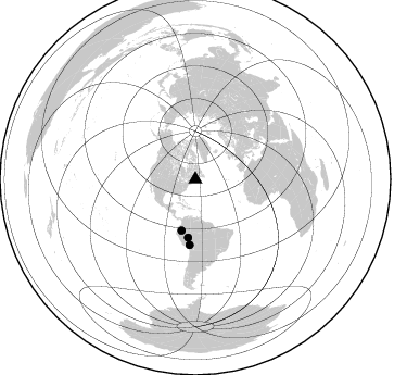
Events Used in the Stack
(3 events)| Radial Match | Distance | Baz | FERegion | Time | Lat/Lon | Depth | Magnitude |
| 97.671646 | 48.9 deg | 195.183 deg | Peru-Ecuador Border Region | 2019/02/22 10:17:22 GMT | (-2.2, -77.0) | 132 km | 7.5 mww |
| 91.18131 | 60.4 deg | 185.002 deg | Central Peru | 2019/03/01 08:50:41 GMT | (-14.7, -70.1) | 257 km | 7.0 mww |
| 81.289734 | 54.0 deg | 187.274 deg | Western Brazil | 2019/01/05 19:25:38 GMT | (-8.1, -71.6) | 575 km | 6.8 Mww |
Losers
(14 events)| Radial Match | Distance | Baz | FERegion | Time | Lat/Lon | Depth | Magnitude | Reason |
| 76.59943 | 43.6 deg | 194.766 deg | Colombia | 2019/01/26 12:32:27 GMT | (3.0, -75.8) | 10 km | 5.6 Mww | |
| 75.55745 | 75.7 deg | 185.175 deg | Near Coast Of Central Chile | 2019/01/20 01:32:51 GMT | (-30.1, -71.4) | 53 km | 6.7 mww | |
| 74.94878 | 91.7 deg | 31.977 deg | Northwestern Kashmir | 2019/02/05 16:47:08 GMT | (35.1, 74.2) | 33 km | 5.3 Mww | |
| 61.948357 | 60.7 deg | 190.838 deg | Near Coast Of Peru | 2019/01/25 04:45:21 GMT | (-14.5, -75.4) | 57 km | 5.6 Mww | |
| 59.843834 | 90.7 deg | 339.092 deg | Near East Coast Of Honshu, Japan | 2019/01/26 08:23:02 GMT | (40.3, 142.2) | 37 km | 5.5 Mww | |
| 59.076027 | 49.6 deg | 232.906 deg | Northern East Pacific Rise | 2019/01/18 16:40:42 GMT | (8.3, -103.5) | 10 km | 6.0 Mww | |
| 58.27165 | 79.0 deg | 130.014 deg | Southern Mid-Atlantic Ridge | 2019/02/22 21:15:58 GMT | (-17.8, -13.5) | 10 km | 5.5 Mww | |
| 57.893303 | 67.4 deg | 320.798 deg | Andreanof Islands, Aleutian Is. | 2019/01/05 18:47:11 GMT | (51.0, -178.2) | 35 km | 6.0 Mi | |
| 52.294018 | 38.2 deg | 224.545 deg | Near Coast Of Chiapas, Mexico | 2019/02/01 16:14:13 GMT | (14.8, -92.3) | 68 km | 6.6 Mww | |
| 50.922714 | 88.6 deg | 339.001 deg | Hokkaido, Japan Region | 2018/12/29 19:08:30 GMT | (42.3, 143.2) | 58 km | 5.5 mb | |
| 47.600357 | 49.7 deg | 198.78 deg | Near Coast Of Ecuador | 2019/02/04 17:45:47 GMT | (-2.4, -79.9) | 70 km | 5.8 Mww | |
| 42.591827 | 50.8 deg | 190.783 deg | Peru-Brazil Border Region | 2019/01/08 10:00:09 GMT | (-4.6, -74.0) | 10 km | 5.1 Mww | |
| 38.281204 | 57.5 deg | 316.191 deg | Alaska Peninsula | 2018/12/31 02:35:38 GMT | (54.3, -161.4) | 34 km | 5.8 Mi | |
| 36.901146 | 79.1 deg | 51.898 deg | Iran-Iraq Border Region | 2019/01/06 13:42:01 GMT | (34.1, 45.7) | 25 km | 5.8 mb |

