
Station CN SV5S - Aquistore NE02, SK, CA
Network: CN - Canadian National Seismograph Network
Nearby stations (2 deg radius)
| Station | Name | (Lat, Lon) | Start / End | Elevation |
| SV5S | Aquistore NE02, SK, CA | (49.10, -103.06) | 2016-11-30 / 2599-12-31 | 550 m |
| Crust2 Type: | H5,early/mid Proter. shield, Africa, 3 km seds. |
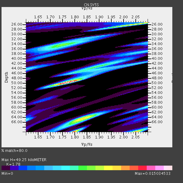
| Thickness Estimate: | 49 km |
| Thickness StdDev: | 6.7 km |
| Vp/Vs Estimate: | 1.78 |
| Vp/Vs StdDev: | 0.03 |
| Vs Estimate: | 3.617 km/s |
| Poisson's Ratio: | 0.27 |
| Peak Value: | 0.02 |
| Assumed Vp: | 6.438 km/s |
| Ps Weight: | 0.33333334 |
| PpPs Weight: | 0.33333334 |
| PsPs Weight: | 0.33333328 |
| Residual Complexity: | 0.841 |
| Nearby stations H: | +- |
| (2.0 deg) Vp/Vs: | +- |
2 with match > 90% ( 14.285714 %) and 2 with match > 80% ( 14.285714 %) out of 14.
Download stack as xyz text file.
Azimuth Distribution of Events:
Prior Results for this Station
| Study | Thickness | Vp/Vs | Vp | Vs | Poissons Ratio | Extra |
| EARS | 49 km | 1.78 | 6.438 km/s | 3.617 km/s | 0.27 | |
| Crust2.0 | 48 km | 1.78 | 6.438 km/s | 3.613 km/s | 0.27 | H5,early/mid Proter. shield, Africa, 3 km seds. |
| Global Maxima | 49 km | 1.78 | 6.438 km/s | 3.617 km/s | 0.27 | amp=0.015034533 |
| Local Maxima 1 | 70 km | 1.80 | 6.438 km/s | 3.586 km/s | 0.27 | amp=0.012400694 |
| Local Maxima 2 | 70 km | 2.05 | 6.438 km/s | 3.14 km/s | 0.34 | amp=0.011152307 |
| Local Maxima 3 | 25 km | 2.08 | 6.438 km/s | 3.102 km/s | 0.35 | amp=0.009869027 |
| Local Maxima 4 | 65 km | 1.82 | 6.438 km/s | 3.542 km/s | 0.28 | amp=0.008600864 |
| Predicted Arrivals for vertical incidence (zero ray parameter) | |
| Ps | 5.97 SECOND |
| PpPs | 21.27 SECOND |
| PsPs/PpSs | 27.24 SECOND |
Events Processed for this Station
Download zip of receiver functions as SAC
Plot maxima for each earthquake.
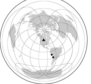
Events Used in the Stack
(2 events)| Radial Match | Distance | Baz | FERegion | Time | Lat/Lon | Depth | Magnitude |
| 96.99258 | 67.9 deg | 150.96 deg | Near Coast Of Peru | 2019/01/25 04:45:21 GMT | (-14.5, -75.4) | 57 km | 5.6 Mww |
| 96.65038 | 80.1 deg | 150.733 deg | Near Coast Of Northern Chile | 2019/01/30 07:44:44 GMT | (-25.9, -70.7) | 39 km | 5.6 Mww |
Losers
(12 events)| Radial Match | Distance | Baz | FERegion | Time | Lat/Lon | Depth | Magnitude | Reason |
| 87.39888 | 63.3 deg | 144.641 deg | Western Brazil | 2019/01/05 19:25:38 GMT | (-8.1, -71.6) | 575 km | 6.8 Mww | |
| 75.42508 | 83.7 deg | 152.777 deg | Near Coast Of Central Chile | 2019/01/20 01:32:51 GMT | (-30.1, -71.4) | 53 km | 6.7 mww | |
| 66.60307 | 56.9 deg | 148.254 deg | Northern Peru | 2019/01/18 21:27:01 GMT | (-3.3, -76.9) | 103 km | 5.7 Mww | |
| 58.18607 | 35.4 deg | 161.809 deg | Near Coast Of Chiapas, Mexico | 2019/02/01 16:14:13 GMT | (14.8, -92.3) | 68 km | 6.6 Mww | |
| 54.229446 | 84.2 deg | 303.088 deg | Volcano Islands, Japan Region | 2019/01/05 22:54:13 GMT | (25.8, 144.6) | 8.3 km | 5.8 Mww | |
| 52.723217 | 94.1 deg | 242.0 deg | Tonga Islands | 2019/01/11 05:58:11 GMT | (-21.4, -173.9) | 10 km | 5.2 Mww | |
| 51.48753 | 46.3 deg | 302.37 deg | Andreanof Islands, Aleutian Is. | 2019/01/05 18:47:11 GMT | (51.0, -178.2) | 35 km | 6.0 Mi | |
| 50.421116 | 90.3 deg | 246.232 deg | Tonga Islands | 2019/02/02 07:02:00 GMT | (-15.7, -174.9) | 260 km | 5.4 mww | |
| 42.588444 | 35.6 deg | 301.014 deg | Alaska Peninsula | 2018/12/31 02:35:38 GMT | (54.3, -161.4) | 34 km | 5.8 Mi | |
| 41.38058 | 40.7 deg | 180.612 deg | Northern East Pacific Rise | 2019/01/18 16:40:42 GMT | (8.3, -103.5) | 10 km | 6.0 Mww | |
| 35.699535 | 72.0 deg | 314.398 deg | Hokkaido, Japan Region | 2018/12/29 19:08:30 GMT | (42.3, 143.2) | 58 km | 5.5 mb | |
| 27.556002 | 72.2 deg | 315.525 deg | Hokkaido, Japan Region | 2019/02/21 12:22:41 GMT | (42.8, 141.9) | 41 km | 5.5 Mww |

