
Station EC PORT - OVCHIM_S
Network: EC - Ecuador Seismic Network
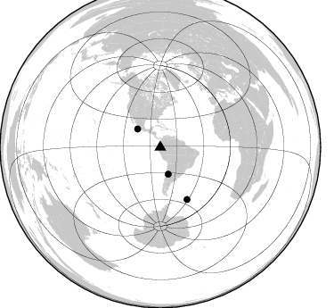
Nearby stations (2 deg radius)

| Station | Name | (Lat, Lon) | Start / End | Elevation |
| PORT | OVCHIM_S | (-1.46, -78.77) | 2012-08-21 / 2599-12-31 | 4469 m |
| Crust2 Type: | R0,orogen/60km Tibet Transition, 1 km seds. |
| Thickness Estimate: | 56 km |
| Thickness StdDev: | 12 km |
| Vp/Vs Estimate: | 1.80 |
| Vp/Vs StdDev: | 0.10 |
| Vs Estimate: | 3.591 km/s |
| Poisson's Ratio: | 0.28 |
| Peak Value: | 0.01 |
| Assumed Vp: | 6.472 km/s |
| Ps Weight: | 0.33333334 |
| PpPs Weight: | 0.33333334 |
| PsPs Weight: | 0.33333328 |
| Residual Complexity: | 0.868 |
| Nearby stations H: | +- |
| (2.0 deg) Vp/Vs: | +- |
0 with match > 90% ( 0.0 %) and 3 with match > 80% ( 9.67742 %) out of 31.
Download stack as xyz text file.
Azimuth Distribution of Events:
Prior Results for this Station
| Study | Thickness | Vp/Vs | Vp | Vs | Poissons Ratio | Extra |
| EARS | 56 km | 1.80 | 6.472 km/s | 3.591 km/s | 0.28 | |
| Crust2.0 | 60 km | 1.76 | 6.472 km/s | 3.676 km/s | 0.26 | R0,orogen/60km Tibet Transition, 1 km seds. |
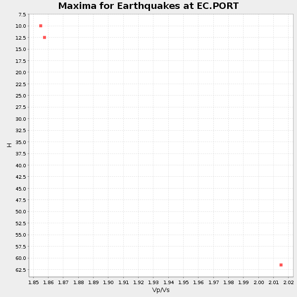
| Global Maxima | 56 km | 1.80 | 6.472 km/s | 3.591 km/s | 0.28 | amp=0.014387248 |
| Local Maxima 1 | 56 km | 1.94 | 6.472 km/s | 3.336 km/s | 0.32 | amp=0.012603405 |
| Local Maxima 2 | 70 km | 1.91 | 6.472 km/s | 3.38 km/s | 0.31 | amp=0.009279978 |
| Local Maxima 3 | 30 km | 1.86 | 6.472 km/s | 3.475 km/s | 0.30 | amp=0.008148232 |
| Local Maxima 4 | 40 km | 2.10 | 6.472 km/s | 3.086 km/s | 0.35 | amp=0.0080222655 |
| Predicted Arrivals for vertical incidence (zero ray parameter) | |
| Ps | 6.88 SECOND |
| PpPs | 24.03 SECOND |
| PsPs/PpSs | 30.91 SECOND |
Events Processed for this Station
Download zip of receiver functions as SAC
Plot maxima for each earthquake.
Events Used in the Stack
(3 events)| Radial Match | Distance | Baz | FERegion | Time | Lat/Lon | Depth | Magnitude |
| 83.283424 | 32.6 deg | 308.454 deg | Off Coast Of Jalisco, Mexico | 2016/06/07 10:51:38 GMT | (18.4, -105.2) | 10 km | 6.2 MWP |
| 82.28938 | 31.5 deg | 163.506 deg | San Juan Province, Argentina | 2016/11/20 20:57:43 GMT | (-31.6, -68.8) | 116 km | 6.4 MWP, 6.5 MWB |
| 80.88632 | 65.7 deg | 152.794 deg | South Georgia Island Region | 2016/08/19 07:32:22 GMT | (-55.3, -31.9) | 10 km | 7.4 MO |
Losers
(28 events)| Radial Match | Distance | Baz | FERegion | Time | Lat/Lon | Depth | Magnitude | Reason |
| 86.418 | 96.2 deg | 241.85 deg | Kermadec Islands Region | 2016/07/13 13:04:25 GMT | (-27.9, -176.5) | 10 km | 5.7 MB | |
| 79.0155 | 68.1 deg | 151.393 deg | South Sandwich Islands Region | 2016/04/19 05:25:39 GMT | (-55.6, -27.2) | 11 km | 5.9 MB | |
| 76.784935 | 66.1 deg | 152.411 deg | South Sandwich Islands Region | 2016/09/02 01:57:53 GMT | (-55.3, -31.0) | 31 km | 5.6 MB | |
| 75.85617 | 65.7 deg | 152.67 deg | South Georgia Island Region | 2016/08/21 03:45:23 GMT | (-55.3, -31.8) | 10 km | 6.4 MWP | |
| 75.717155 | 61.0 deg | 89.246 deg | North Of Ascension Island | 2016/08/29 04:29:57 GMT | (-0.0, -17.8) | 10 km | 7.1 MWW, 7.1 MWC, 7.4 MI | |
| 70.215614 | 46.4 deg | 82.456 deg | Central Mid-Atlantic Ridge | 2016/02/27 02:41:46 GMT | (4.5, -32.7) | 10 km | 5.5 MB | |
| 68.513115 | 66.4 deg | 152.217 deg | South Sandwich Islands Region | 2016/08/30 15:46:02 GMT | (-55.3, -30.4) | 10 km | 5.6 MB | |
| 67.49767 | 85.3 deg | 327.408 deg | Alaska Peninsula | 2016/04/02 05:50:00 GMT | (57.0, -158.0) | 10 km | 6.2 MWP, 6.4 MI | |
| 67.34607 | 96.1 deg | 247.24 deg | South Of Fiji Islands | 2016/12/03 14:11:09 GMT | (-22.6, -176.0) | 153 km | 5.5 mb | |
| 67.07013 | 41.3 deg | 337.623 deg | Oklahoma | 2016/09/03 12:02:44 GMT | (36.4, -96.9) | 5.4 km | 5.8 MWW, 5.6 MWB, 5.7 MWR, 5.8 MWC | |
| 65.82551 | 94.4 deg | 321.431 deg | Andreanof Islands, Aleutian Is. | 2016/03/12 18:06:45 GMT | (51.6, -174.0) | 19 km | 6.3 MWW, 6.1 MB, 6.2 MWB, 6.3 MWC, 6.4 MWC, 6.4 MI | |
| 65.079506 | 65.6 deg | 152.729 deg | South Georgia Island Region | 2016/08/19 17:33:40 GMT | (-55.2, -32.1) | 4.3 km | 5.8 MWW, 5.7 MWB, 5.8 MWC | |
| 64.95002 | 33.8 deg | 170.746 deg | Near Coast Of Central Chile | 2016/08/30 08:09:10 GMT | (-34.9, -72.5) | 19 km | 5.5 MB, 5.5 MB | |
| 62.275826 | 68.6 deg | 152.09 deg | South Sandwich Islands Region | 2016/03/14 07:26:43 GMT | (-56.4, -27.1) | 104 km | 5.7 MB | |
| 61.51987 | 70.2 deg | 154.671 deg | South Sandwich Islands Region | 2016/04/24 08:38:00 GMT | (-59.3, -27.0) | 10 km | 5.5 MB | |
| 60.548527 | 68.2 deg | 152.055 deg | South Sandwich Islands Region | 2016/02/18 01:07:14 GMT | (-56.2, -27.6) | 119 km | 5.8 MB | |
| 58.455845 | 92.7 deg | 50.897 deg | Tyrrhenian Sea | 2016/10/28 20:02:48 GMT | (39.3, 13.5) | 448 km | 5.8 MWW, 5.8 MWB | |
| 58.083412 | 65.8 deg | 26.474 deg | Reykjanes Ridge | 2016/06/25 17:54:19 GMT | (53.9, -35.4) | 10 km | 5.5 MWC, 5.5 MWC | |
| 56.230873 | 93.4 deg | 249.791 deg | Tonga Islands Region | 2016/11/16 00:30:28 GMT | (-20.2, -173.0) | 10 km | 5.9 MB, 5.6 MWB | |
| 54.886154 | 68.3 deg | 152.069 deg | South Sandwich Islands Region | 2016/07/31 11:33:20 GMT | (-56.3, -27.5) | 98 km | 5.9 MWW, 5.9 MWC, 5.9 MWB | |
| 52.847893 | 93.2 deg | 252.343 deg | Tonga Islands Region | 2016/06/05 22:33:49 GMT | (-17.6, -172.6) | 10 km | 5.6 MWW, 5.6 MWC, 5.6 MWB | |
| 50.62946 | 32.2 deg | 158.814 deg | Cordoba Province, Argentina | 2016/09/09 00:03:43 GMT | (-31.4, -65.7) | 151 km | 5.6 MWR | |
| 50.14 | 65.2 deg | 97.489 deg | Ascension Island Region | 2016/06/10 09:26:53 GMT | (-7.5, -13.6) | 10 km | 5.5 MWP | |
| 49.651382 | 97.1 deg | 236.74 deg | South Of Kermadec Islands | 2016/03/05 18:45:30 GMT | (-32.9, -178.2) | 10 km | 5.5 MB | |
| 46.380993 | 54.6 deg | 43.775 deg | Northern Mid-Atlantic Ridge | 2016/07/15 18:02:49 GMT | (35.2, -35.2) | 16 km | 5.5 mwb | |
| 46.37327 | 39.8 deg | 51.991 deg | Northern Mid-Atlantic Ridge | 2016/09/09 17:17:54 GMT | (22.1, -45.9) | 10 km | 5.5 MB | |
| 43.902138 | 68.2 deg | 152.1 deg | South Sandwich Islands Region | 2016/03/28 19:07:09 GMT | (-56.3, -27.7) | 31 km | 5.5 MWC, 5.3 MB, 5.5 MWC | |
| 43.510777 | 87.9 deg | 323.606 deg | Unimak Island Region, Alaska | 2016/10/27 11:53:18 GMT | (53.6, -163.3) | 17 km | 5.8 MWP, 5.8 MI |

