
Station EI IMAC - IMAC
Network: EI - Irish National Seismic Network (INSN)
Nearby stations (2 deg radius)
| Station | Name | (Lat, Lon) | Start / End | Elevation |
| IMAC | IMAC | (51.85, -9.07) | 2022-09-23 / 2099-01-01 | 92 m |
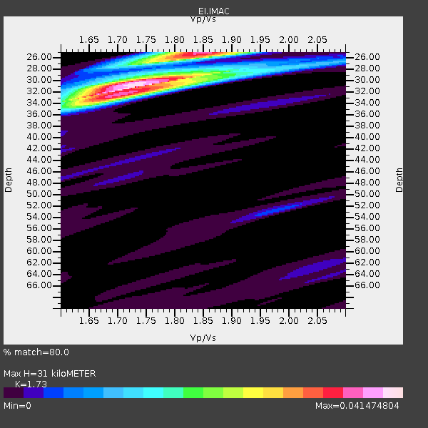
| Crust2 Type: | C3,continental shelf, 2 km seds. |
| Thickness Estimate: | 32 km |
| Thickness StdDev: | 2.2 km |
| Vp/Vs Estimate: | 1.69 |
| Vp/Vs StdDev: | 0.11 |
| Vs Estimate: | 3.624 km/s |
| Poisson's Ratio: | 0.23 |
| Peak Value: | 0.03 |
| Assumed Vp: | 6.134 km/s |
| Ps Weight: | 0.33333334 |
| PpPs Weight: | 0.33333334 |
| PsPs Weight: | 0.33333328 |
| Residual Complexity: | 0.698 |
| Nearby stations H: | +- |
| (2.0 deg) Vp/Vs: | +- |
1 with match > 90% ( 2.2222223 %) and 5 with match > 80% ( 11.111111 %) out of 45.
Download stack as xyz text file.
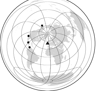
Azimuth Distribution of Events:
Prior Results for this Station
| Study | Thickness | Vp/Vs | Vp | Vs | Poissons Ratio | Extra |
| EARS | 32 km | 1.69 | 6.134 km/s | 3.624 km/s | 0.23 | |
| Crust2.0 | 31 km | 1.80 | 6.134 km/s | 3.406 km/s | 0.28 | C3,continental shelf, 2 km seds. |
| Global Maxima | 32 km | 1.69 | 6.134 km/s | 3.624 km/s | 0.23 | amp=0.03234695 |
| Local Maxima 1 | 25 km | 1.85 | 6.134 km/s | 3.311 km/s | 0.29 | amp=0.027623275 |
| Local Maxima 2 | 30 km | 1.80 | 6.134 km/s | 3.408 km/s | 0.28 | amp=0.022286134 |
| Local Maxima 3 | 30 km | 1.62 | 6.134 km/s | 3.781 km/s | 0.19 | amp=0.010513255 |
| Local Maxima 4 | 26 km | 2.08 | 6.134 km/s | 2.945 km/s | 0.35 | amp=0.009298384 |
| Predicted Arrivals for vertical incidence (zero ray parameter) | |
| Ps | 3.67 SECOND |
| PpPs | 14.27 SECOND |
| PsPs/PpSs | 17.94 SECOND |
Events Processed for this Station
Download zip of receiver functions as SAC
Plot maxima for each earthquake.
Events Used in the Stack
(5 events)| Radial Match | Distance | Baz | FERegion | Time | Lat/Lon | Depth | Magnitude |
| 92.938675 | 71.4 deg | 343.051 deg | Alaska Peninsula | 2023/07/16 06:48:21 UTC | (54.5, -160.8) | 21 km | 7.3 Mi |
| 88.474625 | 87.9 deg | 241.125 deg | Near Coast Of Peru | 2024/06/28 05:36:37 UTC | (-15.8, -74.4) | 28 km | 7.2 mww |
| 85.21289 | 77.5 deg | 291.555 deg | Gulf Of California | 2023/06/18 20:30:30 UTC | (23.2, -108.3) | 33 km | 6.6 Mi |
| 83.976494 | 69.5 deg | 258.011 deg | Panama-Colombia Border Region | 2023/05/25 03:05:34 UTC | (8.9, -77.1) | 10 km | 6.6 Mi |
| 82.750786 | 73.2 deg | 273.148 deg | Guatemala | 2023/05/17 23:02:00 UTC | (15.1, -90.9) | 256 km | 6.4 mww |
Losers
(40 events)| Radial Match | Distance | Baz | FERegion | Time | Lat/Lon | Depth | Magnitude | Reason |
| 78.43174 | 60.1 deg | 108.809 deg | Eastern Gulf Of Aden | 2023/06/03 07:17:46 UTC | (12.6, 48.2) | 10 km | 5.9 mww | |
| 77.99683 | 52.5 deg | 79.743 deg | Northwestern Afghanistan | 2023/10/11 00:41:56 UTC | (34.6, 62.1) | 10 km | 6.3 Mww | |
| 77.5439 | 64.6 deg | 186.033 deg | Southern Mid-Atlantic Ridge | 2023/06/21 04:10:53 UTC | (-12.9, -14.7) | 10 km | 5.5 mww | |
| 76.634865 | 86.3 deg | 26.253 deg | Near West Coast Of Honshu, Japan | 2024/06/02 21:31:38 UTC | (37.5, 137.2) | 4.8 km | 5.8 mww | |
| 75.17034 | 82.7 deg | 21.18 deg | Hokkaido, Japan Region | 2023/06/11 09:54:45 UTC | (42.5, 141.9) | 125 km | 6.2 mww | |
| 74.009384 | 74.7 deg | 273.871 deg | Near Coast Of Chiapas, Mexico | 2024/05/12 11:39:14 UTC | (14.5, -92.4) | 75 km | 6.4 mww | |
| 73.79431 | 56.3 deg | 72.224 deg | Hindu Kush Region, Afghanistan | 2024/01/11 09:20:26 UTC | (36.5, 70.6) | 207 km | 6.4 Mww | |
| 73.18468 | 75.1 deg | 275.421 deg | Near Coast Of Chiapas, Mexico | 2023/07/14 09:29:01 UTC | (15.0, -93.9) | 35 km | 6.3 mww | |
| 72.99769 | 79.3 deg | 243.494 deg | Western Brazil | 2024/01/20 21:31:07 UTC | (-7.3, -71.5) | 629 km | 6.5 Mww | |
| 72.997444 | 86.3 deg | 26.111 deg | Near West Coast Of Honshu, Japan | 2024/01/01 09:03:49 UTC | (37.6, 137.4) | 10 km | 5.5 mb | |
| 70.73723 | 51.3 deg | 251.871 deg | North Atlantic Ocean | 2023/07/10 20:28:25 UTC | (20.0, -61.1) | 10 km | 6.6 mww | |
| 70.42264 | 77.1 deg | 9.474 deg | Kuril Islands | 2023/09/01 20:49:54 UTC | (50.7, 156.3) | 141 km | 6.1 Mww | |
| 70.2954 | 73.3 deg | 269.49 deg | Off Coast Of Central America | 2023/07/19 00:22:07 UTC | (12.8, -88.1) | 70 km | 6.5 mww | |
| 67.80466 | 53.0 deg | 186.506 deg | North Of Ascension Island | 2024/05/04 05:52:35 UTC | (-1.2, -14.3) | 10 km | 5.4 Mww | |
| 64.50562 | 71.2 deg | 343.119 deg | Alaska Peninsula | 2023/07/16 06:51:19 UTC | (54.7, -160.8) | 49 km | 5.7 mb | |
| 63.80314 | 94.2 deg | 26.632 deg | Southeast Of Honshu, Japan | 2023/10/05 02:06:32 UTC | (29.9, 139.9) | 10 km | 5.4 Mww | |
| 62.63627 | 59.5 deg | 246.556 deg | Near Coast Of Venezuela | 2024/06/23 03:58:00 UTC | (10.8, -62.6) | 87 km | 6.0 mww | |
| 62.531796 | 92.0 deg | 33.464 deg | Southeast Of Ryukyu Islands | 2024/04/15 22:38:57 UTC | (29.5, 131.7) | 8.0 km | 5.9 mww | |
| 62.34601 | 86.3 deg | 26.175 deg | Near West Coast Of Honshu, Japan | 2023/05/05 05:42:04 UTC | (37.5, 137.3) | 8.7 km | 6.2 mww | |
| 62.15348 | 78.4 deg | 286.648 deg | Near Coast Of Jalisco, Mexico | 2023/09/08 16:37:17 UTC | (19.5, -104.9) | 45 km | 5.7 mww | |
| 62.04671 | 52.5 deg | 79.722 deg | Northwestern Afghanistan | 2023/10/15 03:36:00 UTC | (34.6, 62.1) | 8.2 km | 6.3 Mww | |
| 58.946487 | 78.8 deg | 61.366 deg | Myanmar | 2024/04/05 12:45:41 UTC | (26.5, 97.0) | 99 km | 5.7 mb | |
| 58.427162 | 78.8 deg | 61.336 deg | Myanmar | 2024/04/05 12:45:31 UTC | (26.6, 97.0) | 10 km | 5.8 mb | |
| 58.246284 | 94.1 deg | 26.608 deg | Southeast Of Honshu, Japan | 2023/10/05 01:59:58 UTC | (30.0, 139.9) | 10 km | 6.1 mww | |
| 58.1411 | 82.4 deg | 15.966 deg | Kuril Islands | 2023/09/28 17:40:04 UTC | (44.3, 148.6) | 15 km | 5.8 mww | |
| 55.764534 | 75.2 deg | 348.521 deg | Fox Islands, Aleutian Islands | 2024/05/19 09:35:24 UTC | (52.2, -170.9) | 28 km | 6.0 mww | |
| 55.38526 | 84.2 deg | 21.002 deg | Hokkaido, Japan Region | 2023/06/17 00:26:15 UTC | (41.2, 142.8) | 34 km | 5.6 Mww | |
| 53.553215 | 79.4 deg | 249.773 deg | Northern Peru | 2024/06/18 02:22:09 UTC | (-3.9, -76.7) | 100 km | 5.5 Mww | |
| 53.45857 | 91.2 deg | 27.761 deg | Southeast Of Honshu, Japan | 2024/05/29 17:14:58 UTC | (32.3, 137.6) | 392 km | 5.5 Mww | |
| 52.72851 | 95.6 deg | 232.296 deg | Near Coast Of Northern Chile | 2023/09/11 13:37:08 UTC | (-27.2, -71.2) | 21 km | 5.5 Mww | |
| 50.339073 | 86.3 deg | 26.104 deg | Near West Coast Of Honshu, Japan | 2024/01/01 09:08:17 UTC | (37.5, 137.4) | 10 km | 5.6 mb | |
| 50.159977 | 89.6 deg | 230.788 deg | Jujuy Province, Argentina | 2023/10/10 10:01:31 UTC | (-22.9, -66.2) | 247 km | 6.0 Mww | |
| 47.301895 | 91.7 deg | 226.478 deg | Santiago Del Estero Prov., Arg. | 2023/08/23 14:22:43 UTC | (-26.9, -63.3) | 569 km | 6.2 mww | |
| 46.604828 | 94.2 deg | 75.978 deg | Northern Sumatra, Indonesia | 2023/07/09 14:09:04 UTC | (5.4, 94.6) | 54 km | 5.4 Mww | |
| 45.787758 | 79.4 deg | 62.826 deg | Myanmar | 2023/05/31 11:20:13 UTC | (25.1, 96.2) | 10 km | 5.8 Mww | |
| 43.71153 | 33.2 deg | 241.533 deg | Northern Mid-Atlantic Ridge | 2024/03/14 21:10:25 UTC | (29.8, -42.7) | 10 km | 6.0 mww | |
| 43.12478 | 90.7 deg | 26.01 deg | Southeast Of Honshu, Japan | 2023/05/14 10:11:35 UTC | (33.4, 139.3) | 14 km | 5.6 mww | |
| 41.529903 | 97.0 deg | 46.551 deg | Philippine Islands Region | 2023/09/12 11:03:18 UTC | (19.3, 121.2) | 41 km | 6.3 Mww | |
| 22.942074 | 60.1 deg | 108.912 deg | Eastern Gulf Of Aden | 2023/06/03 13:58:03 UTC | (12.6, 48.1) | 10 km | 5.4 mww | |
| 22.656097 | 78.8 deg | 260.027 deg | Off Coast Of Central America | 2023/04/20 10:55:32 UTC | (2.7, -84.4) | 10 km | 5.5 mww |

