
Station ER CON - Truncated Cones, Mt Erebus Volcano Observatory Network
Network: ER - Mount Erebus Volcano Observatory Seismic Network
Nearby stations (2 deg radius)
| Station | Name | (Lat, Lon) | Start / End | Elevation |
| CON | Truncated Cones, Mt Erebus Volcano Observatory Network | (-77.53, 167.08) | 1999-01-01 / 2599-12-31 | 3456 m |
| Crust2 Type: | S1,continental slope, margin, transition 1 km seds. |
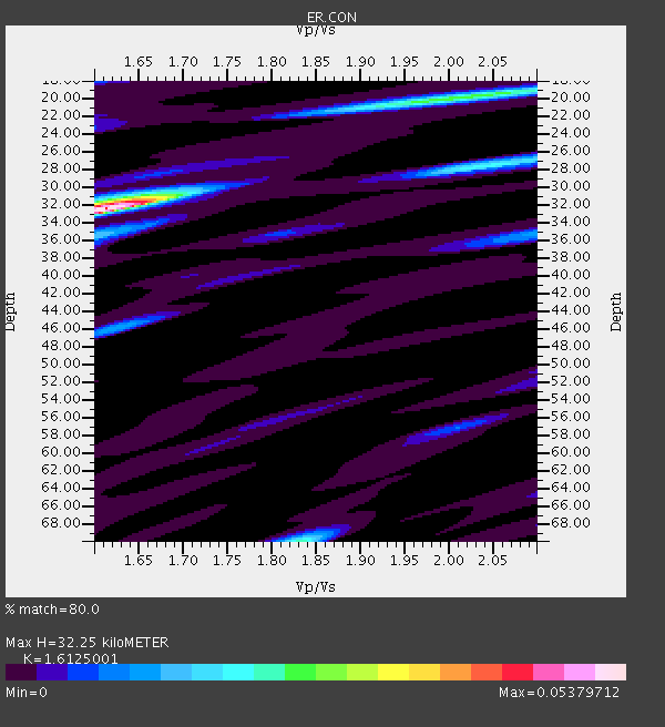
| Thickness Estimate: | 32 km |
| Thickness StdDev: | 3.6 km |
| Vp/Vs Estimate: | 1.61 |
| Vp/Vs StdDev: | 0.13 |
| Vs Estimate: | 3.834 km/s |
| Poisson's Ratio: | 0.19 |
| Peak Value: | 0.05 |
| Assumed Vp: | 6.183 km/s |
| Ps Weight: | 0.33333334 |
| PpPs Weight: | 0.33333334 |
| PsPs Weight: | 0.33333328 |
| Residual Complexity: | 0.512 |
| Nearby stations H: | 26 km +- 11 km |
| (2.0 deg) Vp/Vs: | 1.74 +- 0.19 |
0 with match > 90% ( 0.0 %) and 4 with match > 80% ( 22.222221 %) out of 18.
Download stack as xyz text file.
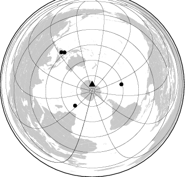
Azimuth Distribution of Events:
Prior Results for this Station
| Study | Thickness | Vp/Vs | Vp | Vs | Poissons Ratio | Extra |
| EARS | 32 km | 1.61 | 6.183 km/s | 3.834 km/s | 0.19 | |
| Crust2.0 | 23 km | 1.81 | 6.183 km/s | 3.422 km/s | 0.28 | S1,continental slope, margin, transition 1 km seds. |
| Global Maxima | 32 km | 1.61 | 6.183 km/s | 3.834 km/s | 0.19 | amp=0.05379712 |
| Local Maxima 1 | 70 km | 1.83 | 6.183 km/s | 3.374 km/s | 0.29 | amp=0.022653218 |
| Local Maxima 2 | 20 km | 2.00 | 6.183 km/s | 3.099 km/s | 0.33 | amp=0.019089527 |
| Local Maxima 3 | 46 km | 1.62 | 6.183 km/s | 3.811 km/s | 0.19 | amp=0.012668878 |
| Local Maxima 4 | 35 km | 2.10 | 6.183 km/s | 2.948 km/s | 0.35 | amp=0.01151386 |
| Predicted Arrivals for vertical incidence (zero ray parameter) | |
| Ps | 3.19 SECOND |
| PpPs | 13.63 SECOND |
| PsPs/PpSs | 16.82 SECOND |
Events Processed for this Station
Download zip of receiver functions as SAC
Plot maxima for each earthquake.
Events Used in the Stack
(4 events)| Radial Match | Distance | Baz | FERegion | Time | Lat/Lon | Depth | Magnitude |
| 89.78536 | 53.1 deg | 219.086 deg | Prince Edward Islands Region | 2014/11/17 16:52:46 GMT | (-46.4, 33.8) | 10 km | 6.2 MWB |
| 88.02323 | 57.4 deg | 89.629 deg | Easter Island Region | 2014/11/01 10:59:55 GMT | (-31.8, -111.2) | 10 km | 6.0 MWP |
| 82.31135 | 87.0 deg | 316.272 deg | Mindanao, Philippines | 2014/12/02 05:11:31 GMT | (6.1, 123.1) | 614 km | 6.6 MWW, 6.6 MWC, 6.6 MWB |
| 81.32723 | 82.6 deg | 319.184 deg | Northern Molucca Sea | 2014/12/21 11:34:13 GMT | (2.1, 126.7) | 41 km | 6.3 MWW, 6.3 MWB, 6.4 MWC, 6.6 MI |
Losers
(14 events)| Radial Match | Distance | Baz | FERegion | Time | Lat/Lon | Depth | Magnitude | Reason |
| 95.34458 | 57.2 deg | 89.999 deg | Southern East Pacific Rise | 2014/10/09 02:32:05 GMT | (-32.1, -110.9) | 10 km | 6.6 MWW, 6.6 MWC | |
| 94.0889 | 72.1 deg | 340.245 deg | New Britain Region, P.N.G. | 2014/11/07 03:33:54 GMT | (-6.0, 148.2) | 43 km | 6.6 MWW, 6.6 MWB, 6.9 MI | |
| 85.85201 | 58.4 deg | 16.852 deg | Fiji Islands Region | 2014/11/01 18:57:22 GMT | (-19.7, -177.7) | 434 km | 7.1 MWW, 6.9 MI, 7.1 MWC, 7.2 MWB | |
| 85.02942 | 54.9 deg | 4.923 deg | Southeast Of Loyalty Islands | 2014/11/10 10:04:21 GMT | (-22.8, 171.4) | 10 km | 6.1 MWP | |
| 84.72546 | 71.3 deg | 346.738 deg | Solomon Islands | 2014/12/07 01:22:00 GMT | (-6.5, 154.5) | 10 km | 6.8 MWP, 6.7 MI, 6.8 MI | |
| 75.63939 | 49.2 deg | 261.592 deg | Mid-Indian Ridge | 2014/11/03 08:48:28 GMT | (-41.7, 79.7) | 10 km | 5.7 MB | |
| 70.589775 | 71.5 deg | 346.615 deg | Solomon Islands | 2014/12/09 02:33:34 GMT | (-6.4, 154.3) | 10 km | 5.6 MB | |
| 69.08394 | 72.1 deg | 341.576 deg | New Britain Region, P.N.G. | 2014/10/01 03:38:54 GMT | (-6.0, 149.5) | 58 km | 5.7 MB | |
| 68.487175 | 73.9 deg | 321.898 deg | Banda Sea | 2014/12/06 22:05:10 GMT | (-6.1, 130.5) | 117 km | 6.0 MB | |
| 63.92312 | 75.9 deg | 127.667 deg | Chile-Bolivia Border Region | 2014/11/10 11:38:58 GMT | (-21.6, -68.5) | 104 km | 5.8 MB | |
| 61.88978 | 78.3 deg | 314.186 deg | Sulawesi, Indonesia | 2014/12/03 00:27:05 GMT | (-2.9, 122.4) | 21 km | 5.7 MB, 5.5 MWB | |
| 61.327927 | 56.5 deg | 89.445 deg | Southern East Pacific Rise | 2014/10/09 08:14:23 GMT | (-32.7, -111.6) | 10 km | 5.6 MB | |
| 60.003845 | 90.3 deg | 320.49 deg | Philippine Islands Region | 2014/11/10 04:41:21 GMT | (10.0, 126.8) | 64 km | 5.5 MB | |
| 55.74109 | 75.1 deg | 308.638 deg | Bali Sea | 2014/10/30 12:11:36 GMT | (-7.0, 117.6) | 546 km | 5.7 MB |

