
Station ET S2NC - Sparta, NC aftershock station S2NC
Network: ET - CERI Southern Appalachian seismic Network
Nearby stations (2 deg radius)
| Station | Name | (Lat, Lon) | Start / End | Elevation |
| S2NC | Sparta, NC aftershock station S2NC | (36.46, -81.15) | 2020-08-10 / 2499-01-01 | 934 m |
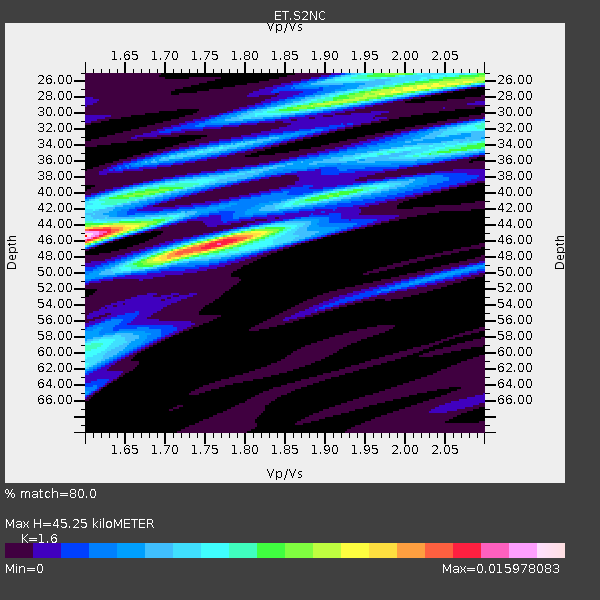
| Crust2 Type: | P1,orogen/46km, Urals, Tethian Orogen, 2 km seds. |
| Thickness Estimate: | 45 km |
| Thickness StdDev: | 8.3 km |
| Vp/Vs Estimate: | 1.60 |
| Vp/Vs StdDev: | 0.17 |
| Vs Estimate: | 3.849 km/s |
| Poisson's Ratio: | 0.18 |
| Peak Value: | 0.02 |
| Assumed Vp: | 6.159 km/s |
| Ps Weight: | 0.33333334 |
| PpPs Weight: | 0.33333334 |
| PsPs Weight: | 0.33333328 |
| Residual Complexity: | 0.810 |
| Nearby stations H: | +- |
| (2.0 deg) Vp/Vs: | +- |
2 with match > 90% ( 11.764706 %) and 8 with match > 80% ( 47.058823 %) out of 17.
Download stack as xyz text file.
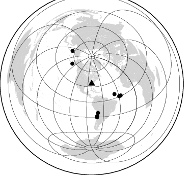
Azimuth Distribution of Events:
Prior Results for this Station
| Study | Thickness | Vp/Vs | Vp | Vs | Poissons Ratio | Extra |
| EARS | 45 km | 1.60 | 6.159 km/s | 3.849 km/s | 0.18 | |
| Crust2.0 | 46 km | 1.76 | 6.159 km/s | 3.507 km/s | 0.26 | P1,orogen/46km, Urals, Tethian Orogen, 2 km seds. |
| Global Maxima | 45 km | 1.60 | 6.159 km/s | 3.849 km/s | 0.18 | amp=0.015978083 |
| Local Maxima 1 | 46 km | 1.77 | 6.159 km/s | 3.484 km/s | 0.26 | amp=0.0136659285 |
| Local Maxima 2 | 25 km | 1.99 | 6.159 km/s | 3.103 km/s | 0.33 | amp=0.008124262 |
| Local Maxima 3 | 34 km | 2.07 | 6.159 km/s | 2.982 km/s | 0.35 | amp=0.006920902 |
| Local Maxima 4 | 27 km | 2.02 | 6.159 km/s | 3.049 km/s | 0.34 | amp=0.006655983 |
| Predicted Arrivals for vertical incidence (zero ray parameter) | |
| Ps | 4.41 SECOND |
| PpPs | 19.10 SECOND |
| PsPs/PpSs | 23.51 SECOND |
Events Processed for this Station
Download zip of receiver functions as SAC
Plot maxima for each earthquake.
Events Used in the Stack
(8 events)| Radial Match | Distance | Baz | FERegion | Time | Lat/Lon | Depth | Magnitude |
| 97.53897 | 54.9 deg | 315.901 deg | South Of Alaska | 2020/10/19 20:54:40 UTC | (54.7, -159.6) | 41 km | 7.4 Mi |
| 93.45121 | 49.1 deg | 114.626 deg | Central Mid-Atlantic Ridge | 2020/09/06 06:51:19 UTC | (7.7, -37.2) | 10 km | 6.7 Mww |
| 89.81607 | 61.3 deg | 112.219 deg | Central Mid-Atlantic Ridge | 2020/09/18 21:43:59 UTC | (1.0, -26.8) | 10 km | 6.9 Mww |
| 89.63466 | 58.5 deg | 167.689 deg | Northern Chile | 2020/09/11 07:35:57 UTC | (-21.4, -69.9) | 51 km | 6.3 Mww |
| 85.236534 | 75.0 deg | 329.823 deg | Kamchatka Peninsula, Russia | 2020/09/15 03:41:28 UTC | (55.9, 158.5) | 344 km | 6.4 Mww |
| 85.13253 | 67.1 deg | 171.009 deg | Near Coast Of Central Chile | 2020/09/06 01:16:58 UTC | (-30.3, -71.6) | 31 km | 6.3 Mww |
| 84.875626 | 64.7 deg | 170.458 deg | Near Coast Of Northern Chile | 2020/09/01 21:09:17 UTC | (-27.9, -71.4) | 14 km | 6.5 mww |
| 83.45782 | 59.2 deg | 114.519 deg | Central Mid-Atlantic Ridge | 2020/08/30 21:20:28 UTC | (0.9, -29.7) | 10 km | 6.5 mww |
Losers
(9 events)| Radial Match | Distance | Baz | FERegion | Time | Lat/Lon | Depth | Magnitude | Reason |
| 73.05287 | 57.5 deg | 315.308 deg | Unimak Island Region, Alaska | 2020/08/13 06:39:58 UTC | (53.4, -163.7) | 10 km | 5.7 mww | |
| 69.198524 | 65.8 deg | 211.604 deg | Easter Island Region | 2020/08/15 06:40:38 UTC | (-22.7, -112.3) | 10 km | 5.7 mww | |
| 67.03863 | 81.5 deg | 51.831 deg | Crete, Greece | 2020/10/12 04:11:27 UTC | (35.6, 26.2) | 10 km | 5.2 Mww | |
| 65.05655 | 55.0 deg | 316.16 deg | South Of Alaska | 2020/10/06 05:54:50 UTC | (54.8, -159.9) | 30 km | 5.6 ml | |
| 59.79299 | 61.5 deg | 315.243 deg | Fox Islands, Aleutian Islands | 2020/09/27 04:12:17 UTC | (51.9, -169.8) | 14 km | 5.6 mww | |
| 59.394802 | 40.2 deg | 181.082 deg | Near Coast Of Northern Peru | 2020/10/18 06:58:29 UTC | (-3.9, -81.8) | 10 km | 5.5 Mww | |
| 45.57781 | 81.4 deg | 52.778 deg | Crete, Greece | 2020/09/18 16:28:17 UTC | (35.0, 25.3) | 44 km | 5.9 Mww | |
| 45.087616 | 67.3 deg | 210.421 deg | Easter Island Region | 2020/09/07 17:40:44 UTC | (-24.5, -112.0) | 10 km | 5.6 Mww | |
| 36.3751 | 56.3 deg | 167.73 deg | Near Coast Of Northern Chile | 2020/08/16 03:18:49 UTC | (-19.3, -70.4) | 64 km | 5.1 Mww |

