
Station ET S3NC - Sparta, NC aftershock station S3NC
Network: ET - CERI Southern Appalachian seismic Network
Nearby stations (2 deg radius)

| Station | Name | (Lat, Lon) | Start / End | Elevation |
| S3NC | Sparta, NC aftershock station S3NC | (36.46, -81.07) | 2020-08-11 / 2499-01-01 | 840 m |
| Crust2 Type: | P1,orogen/46km, Urals, Tethian Orogen, 2 km seds. |
| Thickness Estimate: | 58 km |
| Thickness StdDev: | 5.8 km |
| Vp/Vs Estimate: | 1.63 |
| Vp/Vs StdDev: | 0.07 |
| Vs Estimate: | 3.778 km/s |
| Poisson's Ratio: | 0.20 |
| Peak Value: | 0.03 |
| Assumed Vp: | 6.159 km/s |
| Ps Weight: | 0.33333334 |
| PpPs Weight: | 0.33333334 |
| PsPs Weight: | 0.33333328 |
| Residual Complexity: | 0.685 |
| Nearby stations H: | +- |
| (2.0 deg) Vp/Vs: | +- |
2 with match > 90% ( 11.111111 %) and 5 with match > 80% ( 27.777779 %) out of 18.
Download stack as xyz text file.
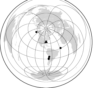
Azimuth Distribution of Events:
Prior Results for this Station
| Study | Thickness | Vp/Vs | Vp | Vs | Poissons Ratio | Extra |
| EARS | 58 km | 1.63 | 6.159 km/s | 3.778 km/s | 0.20 | |
| Crust2.0 | 46 km | 1.76 | 6.159 km/s | 3.507 km/s | 0.26 | P1,orogen/46km, Urals, Tethian Orogen, 2 km seds. |
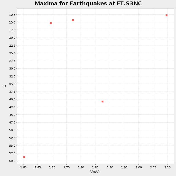
| Global Maxima | 58 km | 1.63 | 6.159 km/s | 3.778 km/s | 0.20 | amp=0.02976077 |
| Local Maxima 1 | 32 km | 2.09 | 6.159 km/s | 2.943 km/s | 0.35 | amp=0.013687117 |
| Local Maxima 2 | 46 km | 1.80 | 6.159 km/s | 3.431 km/s | 0.27 | amp=0.011992159 |
| Local Maxima 3 | 25 km | 2.08 | 6.159 km/s | 2.957 km/s | 0.35 | amp=0.009864771 |
| Local Maxima 4 | 64 km | 1.60 | 6.159 km/s | 3.849 km/s | 0.18 | amp=0.009845378 |
| Predicted Arrivals for vertical incidence (zero ray parameter) | |
| Ps | 5.91 SECOND |
| PpPs | 24.66 SECOND |
| PsPs/PpSs | 30.57 SECOND |
Events Processed for this Station
Download zip of receiver functions as SAC
Plot maxima for each earthquake.
Events Used in the Stack
(5 events)| Radial Match | Distance | Baz | FERegion | Time | Lat/Lon | Depth | Magnitude |
| 98.22908 | 54.9 deg | 315.915 deg | South Of Alaska | 2020/10/19 20:54:40 UTC | (54.7, -159.6) | 41 km | 7.4 Mi |
| 92.62135 | 58.5 deg | 167.771 deg | Northern Chile | 2020/09/11 07:35:57 UTC | (-21.4, -69.9) | 51 km | 6.3 Mww |
| 87.667 | 67.0 deg | 171.081 deg | Near Coast Of Central Chile | 2020/09/06 01:16:58 UTC | (-30.3, -71.6) | 31 km | 6.3 Mww |
| 87.187706 | 61.3 deg | 112.277 deg | Central Mid-Atlantic Ridge | 2020/09/18 21:43:59 UTC | (1.0, -26.8) | 10 km | 6.9 Mww |
| 81.14274 | 64.7 deg | 170.532 deg | Near Coast Of Northern Chile | 2020/09/01 21:09:17 UTC | (-27.9, -71.4) | 14 km | 6.5 mww |
Losers
(13 events)| Radial Match | Distance | Baz | FERegion | Time | Lat/Lon | Depth | Magnitude | Reason |
| 79.25624 | 59.2 deg | 114.58 deg | Central Mid-Atlantic Ridge | 2020/08/30 21:20:28 UTC | (0.9, -29.7) | 10 km | 6.5 mww | |
| 66.17661 | 64.7 deg | 170.483 deg | Near Coast Of Northern Chile | 2020/09/01 05:29:38 UTC | (-28.0, -71.3) | 16 km | 5.5 Mww | |
| 62.551476 | 81.5 deg | 51.87 deg | Crete, Greece | 2020/10/12 04:11:27 UTC | (35.6, 26.2) | 10 km | 5.2 Mww | |
| 49.53189 | 45.8 deg | 213.176 deg | Central East Pacific Rise | 2020/09/21 12:27:57 UTC | (-4.1, -104.2) | 10 km | 5.5 Mww | |
| 46.54345 | 72.9 deg | 331.772 deg | Kamchatka Peninsula, Russia | 2020/09/01 00:51:17 UTC | (58.7, 159.0) | 10 km | 5.6 Mww | |
| 46.25444 | 64.6 deg | 170.609 deg | Near Coast Of Northern Chile | 2020/09/01 10:31:50 UTC | (-27.9, -71.5) | 12 km | 5.7 Mww | |
| 43.033154 | 75.0 deg | 329.854 deg | Kamchatka Peninsula, Russia | 2020/09/15 03:41:28 UTC | (55.9, 158.5) | 344 km | 6.4 Mww | |
| 41.94623 | 33.9 deg | 83.781 deg | Northern Mid-Atlantic Ridge | 2020/10/06 04:24:58 UTC | (32.8, -39.8) | 10 km | 5.6 Mww | |
| 41.10368 | 55.1 deg | 315.586 deg | South Of Alaska | 2020/10/19 21:45:25 UTC | (54.3, -159.9) | 24 km | 5.9 mww | |
| 33.14731 | 71.0 deg | 208.703 deg | Easter Island Region | 2020/10/11 14:41:20 UTC | (-28.6, -112.2) | 10 km | 5.7 Mww | |
| 31.54047 | 57.6 deg | 315.325 deg | Unimak Island Region, Alaska | 2020/08/13 06:39:58 UTC | (53.4, -163.7) | 10 km | 5.7 mww | |
| 26.391148 | 95.1 deg | 327.417 deg | Near East Coast Of Honshu, Japan | 2020/09/12 02:44:10 UTC | (38.8, 142.2) | 32 km | 6.1 mww | |
| 14.683376 | 65.8 deg | 211.673 deg | Easter Island Region | 2020/08/15 06:40:38 UTC | (-22.7, -112.3) | 10 km | 5.7 mww |

