
Station GE LID - GRSN/GEOFON Station Liddow, Germany
Network: GE - GEOFON
Nearby stations (2 deg radius)
| Station | Name | (Lat, Lon) | Start / End | Elevation |
| LID | GRSN/GEOFON Station Liddow, Germany | (54.55, 13.37) | 1994-01-15 / 1995-11-30 | 1.0 m |
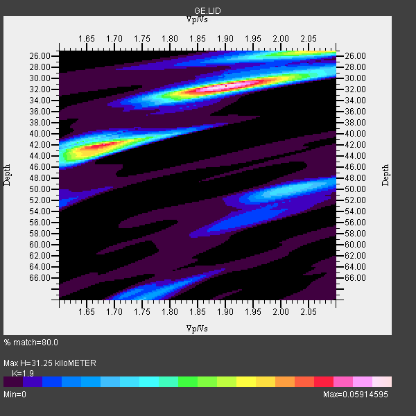
| Crust2 Type: | M1,extended crust, 3 km seds. |
| Thickness Estimate: | 31 km |
| Thickness StdDev: | 6.6 km |
| Vp/Vs Estimate: | 1.90 |
| Vp/Vs StdDev: | 0.15 |
| Vs Estimate: | 3.211 km/s |
| Poisson's Ratio: | 0.31 |
| Peak Value: | 0.06 |
| Assumed Vp: | 6.1 km/s |
| Ps Weight: | 0.33333334 |
| PpPs Weight: | 0.33333334 |
| PsPs Weight: | 0.33333328 |
| Residual Complexity: | 0.638 |
| Nearby stations H: | +- |
| (2.0 deg) Vp/Vs: | +- |
2 with match > 90% ( 14.285714 %) and 4 with match > 80% ( 28.571428 %) out of 14.
Download stack as xyz text file.
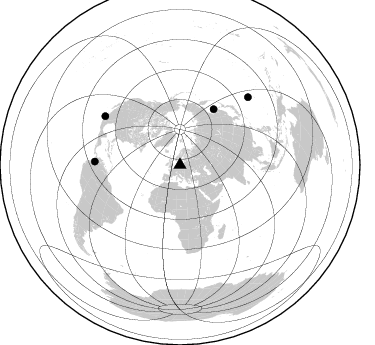
Azimuth Distribution of Events:
Prior Results for this Station
| Study | Thickness | Vp/Vs | Vp | Vs | Poissons Ratio | Extra |
| EARS | 31 km | 1.90 | 6.1 km/s | 3.211 km/s | 0.31 | |
| Crust2.0 | 31 km | 1.78 | 6.1 km/s | 3.426 km/s | 0.27 | M1,extended crust, 3 km seds. |
| Global Maxima | 31 km | 1.90 | 6.1 km/s | 3.211 km/s | 0.31 | amp=0.05914595 |
| Local Maxima 1 | 42 km | 1.68 | 6.1 km/s | 3.631 km/s | 0.23 | amp=0.04831982 |
| Local Maxima 2 | 25 km | 2.05 | 6.1 km/s | 2.976 km/s | 0.34 | amp=0.028798545 |
| Local Maxima 3 | 44 km | 1.65 | 6.1 km/s | 3.697 km/s | 0.21 | amp=0.025000019 |
| Local Maxima 4 | 50 km | 2.02 | 6.1 km/s | 3.027 km/s | 0.34 | amp=0.02072727 |
| Predicted Arrivals for vertical incidence (zero ray parameter) | |
| Ps | 4.61 SECOND |
| PpPs | 14.86 SECOND |
| PsPs/PpSs | 19.47 SECOND |
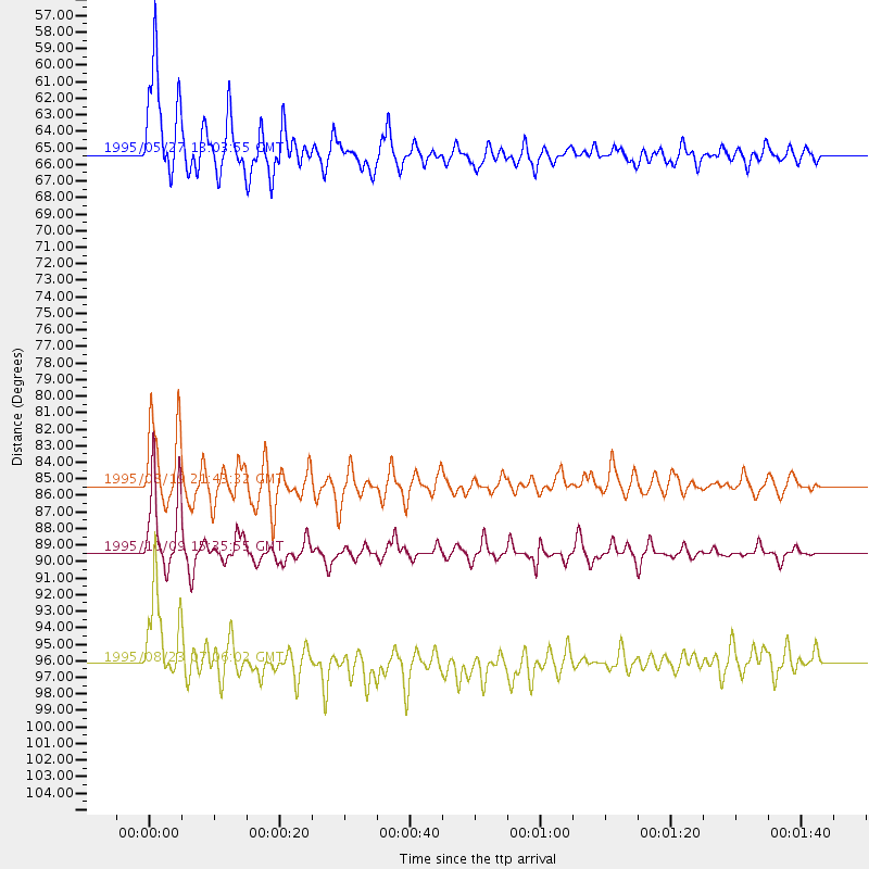
Events Processed for this Station
Download zip of receiver functions as SAC
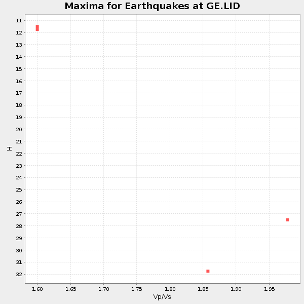
Plot maxima for each earthquake.
Events Used in the Stack
(4 events)| Radial Match | Distance | Baz | FERegion | Time | Lat/Lon | Depth | Magnitude |
| 96.359245 | 65.3 deg | 31.255 deg | Sakhalin, Russia | 1995/05/27 13:03:55 GMT | (52.6, 142.8) | 33 km | 6.6 MB, 7.6 MS, 7.0 UNKNOWN, 7.0 MW |
| 92.97512 | 89.4 deg | 303.078 deg | Near Coast Of Jalisco, Mexico | 1995/10/09 15:35:55 GMT | (19.1, -104.2) | 49 km | 6.5 MB, 7.3 MS, 7.3 UNKNOWN, 7.9 MW |
| 89.599625 | 96.1 deg | 45.219 deg | Mariana Islands | 1995/08/23 07:06:02 GMT | (18.9, 145.2) | 596 km | 6.3 MB, 6.3 UNKNOWN, 7.0 MW |
| 87.37713 | 85.3 deg | 272.189 deg | Colombia | 1995/08/19 21:43:32 GMT | (5.1, -75.7) | 125 km | 6.1 MB, 6.6 UNKNOWN, 6.5 MW |
Losers
(10 events)| Radial Match | Distance | Baz | FERegion | Time | Lat/Lon | Depth | Magnitude | Reason |
| 78.84543 | 86.8 deg | 116.819 deg | South Indian Ocean | 1995/07/27 05:51:17 GMT | (-12.6, 79.2) | 10 km | 6.2 MB, 5.9 MS, 6.0 UNKNOWN, 6.0 MW | |
| 76.22975 | 85.8 deg | 293.23 deg | Chiapas, Mexico | 1995/10/21 02:38:57 GMT | (16.9, -93.5) | 161 km | 6.2 MB, 7.3 UNKNOWN, 7.3 MW | |
| 74.63587 | 72.1 deg | 358.069 deg | Unimak Island Region, Alaska | 1995/07/08 17:15:28 GMT | (53.6, -163.5) | 33 km | 5.8 MB, 5.7 MS, 5.5 UNKNOWN, 6.0 MW | |
| 68.22247 | 76.9 deg | 37.412 deg | Off East Coast Of Honshu, Japan | 1995/07/08 05:42:56 GMT | (39.6, 143.4) | 40 km | 5.7 MB, 5.5 MS, 5.2 UNKNOWN, 6.0 MW | |
| 60.067623 | 43.0 deg | 90.376 deg | Afghanistan-Tajikistan Bord Reg. | 1995/08/17 23:14:19 GMT | (36.5, 71.2) | 239 km | 5.7 UNKNOWN, 5.4 MB, 5.6 MW | |
| 59.82047 | 87.8 deg | 292.811 deg | Off Coast Of Chiapas, Mexico | 1995/09/06 22:48:52 GMT | (15.0, -94.3) | 33 km | 5.8 MB, 5.5 MS | |
| 56.61141 | 79.5 deg | 44.666 deg | Near S. Coast Of Honshu, Japan | 1995/07/07 21:15:18 GMT | (33.9, 137.1) | 324 km | 5.8 MB, 6.0 UNKNOWN, 6.0 MW | |
| 24.685974 | 83.1 deg | 45.548 deg | Southeast Of Honshu, Japan | 1995/07/29 16:18:44 GMT | (30.4, 138.3) | 436 km | 5.5 MB, 5.6 UNKNOWN | |
| 24.39003 | 92.2 deg | 65.349 deg | Samar, Philippines | 1995/07/12 18:38:49 GMT | (12.3, 125.0) | 33 km | 5.8 MB, 5.6 MS, 5.6 UNKNOWN, 6.0 MW | |
| 19.737482 | 84.9 deg | 65.392 deg | Luzon, Philippines | 1995/06/05 20:20:17 GMT | (18.4, 120.9) | 47 km | 5.4 MB, 5.4 MS, 5.8 UNKNOWN |
