
Station GE MELI - UCM/ROA/GEOFON Station Melilla, Spain
Network: GE - GEOFON
Nearby stations (2 deg radius)
| Station | Name | (Lat, Lon) | Start / End | Elevation |
| MELI | UCM/ROA/GEOFON Station Melilla, Spain | (35.29, -2.94) | 1999-12-17 / 2004-02-02 | 40 m |
| MELI | UCM/ROA/GEOFON Station Melilla, Spain | (35.29, -2.93) | 2004-02-02 / 2499-01-01 | 5.0 m |
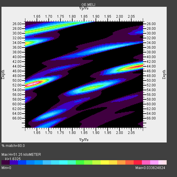
| Crust2 Type: | T4,Margin /shield transition, East Siberia, 2 km seds. |
| Thickness Estimate: | 51 km |
| Thickness StdDev: | 7.2 km |
| Vp/Vs Estimate: | 1.63 |
| Vp/Vs StdDev: | 0.19 |
| Vs Estimate: | 3.915 km/s |
| Poisson's Ratio: | 0.20 |
| Peak Value: | 0.03 |
| Assumed Vp: | 6.391 km/s |
| Ps Weight: | 0.33333334 |
| PpPs Weight: | 0.33333334 |
| PsPs Weight: | 0.33333328 |
| Residual Complexity: | 0.802 |
| Nearby stations H: | +- |
| (2.0 deg) Vp/Vs: | +- |
13 with match > 90% ( 44.827587 %) and 29 with match > 80% ( 100.0 %) out of 29.
Download stack as xyz text file.
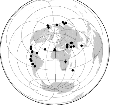
Azimuth Distribution of Events:
Prior Results for this Station
| Study | Thickness | Vp/Vs | Vp | Vs | Poissons Ratio | Extra |
| EARS | 51 km | 1.63 | 6.391 km/s | 3.915 km/s | 0.20 | |
| Crust2.0 | 32 km | 1.79 | 6.391 km/s | 3.572 km/s | 0.27 | T4,Margin /shield transition, East Siberia, 2 km seds. |
| Global Maxima | 51 km | 1.63 | 6.391 km/s | 3.915 km/s | 0.20 | amp=0.033624824 |
| Local Maxima 1 | 34 km | 1.60 | 6.391 km/s | 3.994 km/s | 0.18 | amp=0.023997504 |
| Local Maxima 2 | 53 km | 1.88 | 6.391 km/s | 3.39 km/s | 0.30 | amp=0.019219376 |
| Local Maxima 3 | 30 km | 1.60 | 6.391 km/s | 3.994 km/s | 0.18 | amp=0.018911341 |
| Local Maxima 4 | 44 km | 2.09 | 6.391 km/s | 3.065 km/s | 0.35 | amp=0.016667873 |
| Predicted Arrivals for vertical incidence (zero ray parameter) | |
| Ps | 5.07 SECOND |
| PpPs | 21.11 SECOND |
| PsPs/PpSs | 26.18 SECOND |
Events Processed for this Station
Download zip of receiver functions as SAC
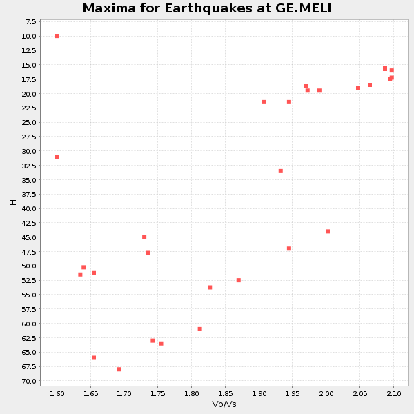
Plot maxima for each earthquake.
Events Used in the Stack
(29 events)| Radial Match | Distance | Baz | FERegion | Time | Lat/Lon | Depth | Magnitude |
| 95.804924 | 86.2 deg | 238.232 deg | Near Coast Of Northern Chile | 2000/01/08 11:59:21 GMT | (-23.2, -70.1) | 36 km | 5.8 MB, 5.9 MS, 6.4 MW, 6.1 ME |
| 95.29598 | 63.6 deg | 79.035 deg | Southern India | 2001/01/26 03:16:40 GMT | (23.4, 70.2) | 16 km | 6.9 MB, 8.0 MS, 7.7 MW, 7.7 ME |
| 94.80142 | 89.6 deg | 80.624 deg | Nicobar Islands, India Region | 2005/07/24 15:42:06 GMT | (7.9, 92.2) | 16 km | 6.6 MB, 7.5 MS, 7.3 MW, 7.2 MW |
| 94.27414 | 84.3 deg | 245.649 deg | Near Coast Of Peru | 2001/06/23 20:33:14 GMT | (-16.3, -73.6) | 33 km | 6.7 MB, 8.2 MS, 8.4 MW, 7.8 ME |
| 94.14827 | 79.9 deg | 255.69 deg | Northern Peru | 2005/09/26 01:55:37 GMT | (-5.7, -76.4) | 115 km | 6.7 MB, 7.5 MW, 7.5 MW |
| 93.575905 | 79.1 deg | 278.297 deg | El Salvador | 2001/01/13 17:33:32 GMT | (13.0, -88.7) | 60 km | 6.4 MB, 7.8 MS, 7.7 MW, 7.5 ME |
| 92.33842 | 84.6 deg | 344.217 deg | Kodiak Island Region, Alaska | 2001/01/10 16:02:44 GMT | (57.1, -153.2) | 33 km | 6.2 MB, 6.8 MS, 7.1 MW, 6.8 ML |
| 91.98527 | 95.7 deg | 16.238 deg | Kuril Islands | 2006/11/15 11:14:13 GMT | (46.6, 153.3) | 10 km | 6.5 MB, 7.8 MS, 8.3 MW, 7.9 MW |
| 91.7503 | 58.1 deg | 65.478 deg | Hindu Kush Region, Afghanistan | 2002/03/03 12:08:19 GMT | (36.5, 70.5) | 226 km | 6.6 MB, 7.4 MW, 7.3 MW |
| 91.07424 | 61.2 deg | 66.379 deg | Pakistan | 2005/10/08 03:50:40 GMT | (34.5, 73.6) | 26 km | 6.9 MB, 7.7 MS, 7.6 MW, 7.3 MW |
| 91.06272 | 74.7 deg | 264.884 deg | Near West Coast Of Colombia | 2004/11/15 09:06:56 GMT | (4.7, -77.5) | 15 km | 6.6 MB, 7.1 MS, 7.2 MW, 7.1 MW |
| 90.47911 | 43.8 deg | 72.153 deg | Northern And Central Iran | 2004/05/28 12:38:44 GMT | (36.2, 51.6) | 17 km | 6.2 MB, 6.4 MS, 6.3 MW, 6.2 MW |
| 90.46344 | 92.8 deg | 20.242 deg | Northwest Of Kuril Islands | 2002/11/17 04:53:53 GMT | (47.8, 146.2) | 459 km | 7.3 MW, 7.3 MW |
| 89.705956 | 42.3 deg | 76.979 deg | Western Iran | 2006/03/31 01:17:00 GMT | (33.5, 48.8) | 7.0 km | 5.7 MB, 6.0 MS, 6.1 MW, 5.9 MW |
| 88.730934 | 78.4 deg | 273.383 deg | Off Coast Of Costa Rica | 2000/07/21 01:53:35 GMT | (9.4, -85.3) | 33 km | 5.9 MB, 6.1 MS, 6.4 MW, 5.7 ML |
| 88.09399 | 77.6 deg | 344.539 deg | Central Alaska | 2002/11/03 22:12:41 GMT | (63.5, -147.4) | 4.9 km | 7.0 MB, 8.5 MS, 7.9 MW |
| 87.86671 | 84.1 deg | 237.501 deg | Chile-Bolivia Border Region | 2005/11/17 19:26:56 GMT | (-22.3, -67.9) | 163 km | 6.0 MB, 6.9 MW, 6.8 MW |
| 87.63276 | 83.8 deg | 4.877 deg | Eastern Siberia, Russia | 2006/04/20 23:25:02 GMT | (60.9, 167.1) | 22 km | 6.8 MB, 7.6 MS, 7.6 MW, 7.3 MW |
| 86.86403 | 96.8 deg | 23.007 deg | Hokkaido, Japan Region | 2004/11/28 18:32:14 GMT | (43.0, 145.1) | 39 km | 6.4 MB, 6.7 MS, 7.0 MW, 7.0 MW |
| 86.45991 | 31.8 deg | 274.586 deg | Northern Mid-Atlantic Ridge | 2000/10/05 13:39:11 GMT | (31.7, -41.0) | 10 km | 5.4 MB, 6.1 MS, 6.0 MW, 5.9 MW |
| 86.43427 | 84.0 deg | 231.214 deg | Santiago Del Estero Prov., Arg. | 2006/09/22 02:32:25 GMT | (-26.9, -63.1) | 598 km | 6.1 MB, 6.0 MW, 6.0 MW |
| 86.43297 | 51.5 deg | 136.593 deg | Lake Tanganyika Region | 2005/12/05 12:19:56 GMT | (-6.2, 29.8) | 22 km | 6.4 MB, 7.2 MS, 6.8 MW, 6.7 MW |
| 85.30726 | 55.2 deg | 79.271 deg | Southern Iran | 2005/03/13 03:31:23 GMT | (27.1, 61.9) | 54 km | 5.9 MB, 5.4 MS, 6.0 MW, 6.0 MW |
| 84.86781 | 84.2 deg | 4.733 deg | Eastern Siberia, Russia | 2006/04/29 16:58:06 GMT | (60.5, 167.5) | 11 km | 6.4 MB, 6.6 MS, 6.6 MW, 6.4 MW |
| 84.64 | 84.8 deg | 249.68 deg | Near Coast Of Peru | 2006/10/20 10:48:56 GMT | (-13.5, -76.7) | 23 km | 5.9 MB, 6.6 MS, 6.7 MW, 6.6 MW |
| 83.52013 | 45.4 deg | 66.686 deg | Turkmenistan | 2000/12/06 17:11:06 GMT | (39.6, 54.8) | 30 km | 6.7 MB, 7.5 MS, 7.0 MW, 6.9 ME |
| 83.50166 | 88.7 deg | 138.027 deg | South Indian Ocean | 2004/01/11 04:32:47 GMT | (-36.7, 53.4) | 5.3 km | 6.1 MB, 6.1 MS, 6.2 MW, 6.2 MW |
| 80.45798 | 73.7 deg | 266.889 deg | Near West Coast Of Colombia | 2006/01/23 20:50:44 GMT | (6.9, -77.8) | 14 km | 6.1 MB, 5.9 MS, 6.2 MW, 6.1 MW |
| 80.09373 | 58.9 deg | 261.36 deg | Windward Islands | 2000/10/04 14:37:44 GMT | (11.1, -62.6) | 110 km | 5.6 MB, 5.4 MS, 6.1 MW, 5.9 MD |
Losers
(0 events)| Radial Match | Distance | Baz | FERegion | Time | Lat/Lon | Depth | Magnitude | Reason |
