
Station GE RIOB - GEOFON Station Rio Branco, Brazil
Network: GE - GEOFON
Nearby stations (2 deg radius)
| Station | Name | (Lat, Lon) | Start / End | Elevation |
| RIOB | GEOFON Station Rio Branco, Brazil | (-10.15, -67.75) | 2002-09-04 / 2499-01-01 | 220 m |
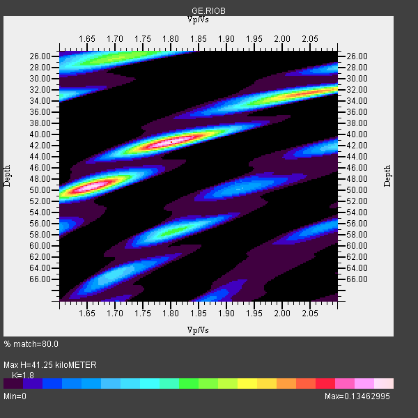
| Crust2 Type: | D9,Platform 1 km seds. |
| Thickness Estimate: | 41 km |
| Thickness StdDev: | 8.7 km |
| Vp/Vs Estimate: | 1.80 |
| Vp/Vs StdDev: | 0.07 |
| Vs Estimate: | 3.61 km/s |
| Poisson's Ratio: | 0.28 |
| Peak Value: | 0.13 |
| Assumed Vp: | 6.498 km/s |
| Ps Weight: | 0.33333334 |
| PpPs Weight: | 0.33333334 |
| PsPs Weight: | 0.33333328 |
| Residual Complexity: | 0.726 |
| Nearby stations H: | +- |
| (2.0 deg) Vp/Vs: | +- |
1 with match > 90% ( 20.0 %) and 5 with match > 80% ( 100.0 %) out of 5.
Download stack as xyz text file.
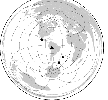
Azimuth Distribution of Events:
Prior Results for this Station
| Study | Thickness | Vp/Vs | Vp | Vs | Poissons Ratio | Extra |
| EARS | 41 km | 1.80 | 6.498 km/s | 3.61 km/s | 0.28 | |
| Crust2.0 | 41 km | 1.77 | 6.498 km/s | 3.666 km/s | 0.27 | D9,Platform 1 km seds. |
| Global Maxima | 41 km | 1.80 | 6.498 km/s | 3.61 km/s | 0.28 | amp=0.13462995 |
| Local Maxima 1 | 50 km | 1.65 | 6.498 km/s | 3.944 km/s | 0.21 | amp=0.11678064 |
| Local Maxima 2 | 32 km | 2.06 | 6.498 km/s | 3.154 km/s | 0.35 | amp=0.08974615 |
| Local Maxima 3 | 26 km | 1.70 | 6.498 km/s | 3.816 km/s | 0.24 | amp=0.07479601 |
| Local Maxima 4 | 57 km | 1.81 | 6.498 km/s | 3.6 km/s | 0.28 | amp=0.0671918 |
| Predicted Arrivals for vertical incidence (zero ray parameter) | |
| Ps | 5.08 SECOND |
| PpPs | 17.78 SECOND |
| PsPs/PpSs | 22.85 SECOND |
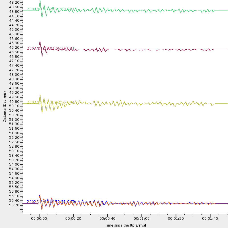
Events Processed for this Station
Download zip of receiver functions as SAC
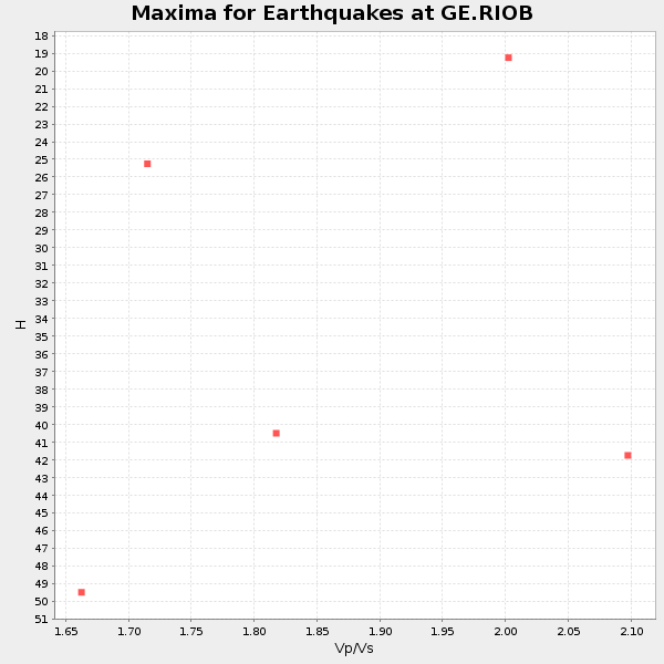
Plot maxima for each earthquake.
Events Used in the Stack
(5 events)| Radial Match | Distance | Baz | FERegion | Time | Lat/Lon | Depth | Magnitude |
| 93.70714 | 46.0 deg | 308.607 deg | Near Coast Of Jalisco, Mexico | 2003/01/22 02:06:34 GMT | (18.8, -104.1) | 24 km | 6.5 MB, 7.6 MS, 7.6 MW, 7.4 MW |
| 89.511215 | 57.2 deg | 153.651 deg | South Sandwich Islands Region | 2002/12/17 04:32:53 GMT | (-57.0, -24.8) | 10 km | 5.4 MB, 6.3 MS, 6.2 MW, 6.0 MW |
| 87.64662 | 43.1 deg | 309.4 deg | Near Coast Of Guerrero, Mexico | 2004/01/01 23:31:50 GMT | (17.5, -101.3) | 29 km | 5.6 MB, 5.7 MS, 6.0 MW, 6.0 MW |
| 86.68429 | 57.2 deg | 153.846 deg | South Sandwich Islands Region | 2002/12/18 14:12:21 GMT | (-57.1, -25.0) | 10 km | 5.5 MB, 6.0 MS, 6.2 MW, 5.9 MW |
| 84.24008 | 49.9 deg | 130.173 deg | Southern Mid-Atlantic Ridge | 2003/03/02 16:42:56 GMT | (-37.0, -20.9) | 10 km | 5.6 MB, 5.5 MS, 6.2 MW, 6.1 MW |
Losers
(0 events)| Radial Match | Distance | Baz | FERegion | Time | Lat/Lon | Depth | Magnitude | Reason |
