
Station GE SELV - IAG Station Sierra Elvira, Spain
Network: GE - GEOFON
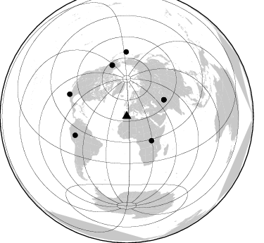
Nearby stations (2 deg radius)
| Station | Name | (Lat, Lon) | Start / End | Elevation |
| SELV | IAG Station Sierra Elvira, Spain | (37.24, -3.73) | 2001-10-27 / 2499-01-01 | 650 m |
| Crust2 Type: | T4,Margin /shield transition, East Siberia, 2 km seds. |
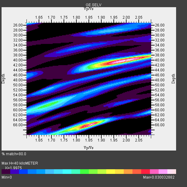
| Thickness Estimate: | 40 km |
| Thickness StdDev: | 13 km |
| Vp/Vs Estimate: | 2.00 |
| Vp/Vs StdDev: | 0.10 |
| Vs Estimate: | 3.199 km/s |
| Poisson's Ratio: | 0.33 |
| Peak Value: | 0.03 |
| Assumed Vp: | 6.391 km/s |
| Ps Weight: | 0.33333334 |
| PpPs Weight: | 0.33333334 |
| PsPs Weight: | 0.33333328 |
| Residual Complexity: | 0.723 |
| Nearby stations H: | +- |
| (2.0 deg) Vp/Vs: | +- |
3 with match > 90% ( 37.5 %) and 8 with match > 80% ( 100.0 %) out of 8.
Download stack as xyz text file.
Azimuth Distribution of Events:
Prior Results for this Station
| Study | Thickness | Vp/Vs | Vp | Vs | Poissons Ratio | Extra |
| EARS | 40 km | 2.00 | 6.391 km/s | 3.199 km/s | 0.33 | |
| Crust2.0 | 32 km | 1.79 | 6.391 km/s | 3.572 km/s | 0.27 | T4,Margin /shield transition, East Siberia, 2 km seds. |
| Global Maxima | 40 km | 2.00 | 6.391 km/s | 3.199 km/s | 0.33 | amp=0.030032882 |
| Local Maxima 1 | 66 km | 1.86 | 6.391 km/s | 3.44 km/s | 0.30 | amp=0.028986925 |
| Local Maxima 2 | 58 km | 1.69 | 6.391 km/s | 3.787 km/s | 0.23 | amp=0.014075457 |
| Local Maxima 3 | 25 km | 1.60 | 6.391 km/s | 3.994 km/s | 0.18 | amp=0.010716364 |
| Local Maxima 4 | 43 km | 1.88 | 6.391 km/s | 3.404 km/s | 0.30 | amp=0.010113592 |
| Predicted Arrivals for vertical incidence (zero ray parameter) | |
| Ps | 6.24 SECOND |
| PpPs | 18.76 SECOND |
| PsPs/PpSs | 25.01 SECOND |
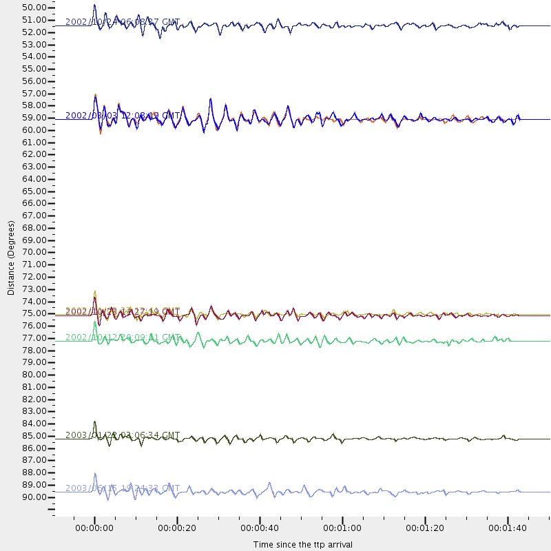
Events Processed for this Station
Download zip of receiver functions as SAC
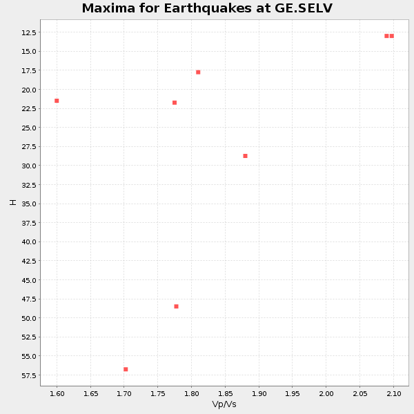
Plot maxima for each earthquake.
Events Used in the Stack
(8 events)| Radial Match | Distance | Baz | FERegion | Time | Lat/Lon | Depth | Magnitude |
| 96.62782 | 86.8 deg | 291.018 deg | Near Coast Of Jalisco, Mexico | 2003/01/22 02:06:34 GMT | (18.8, -104.1) | 24 km | 6.5 MB, 7.6 MS, 7.6 MW, 7.4 MW |
| 91.06518 | 49.4 deg | 134.586 deg | Lake Tanganyika Region | 2002/10/24 06:08:37 GMT | (-1.9, 29.0) | 11 km | 5.9 MB, 6.3 MS, 6.2 MW, 6.1 MW |
| 90.77528 | 75.5 deg | 344.096 deg | Central Alaska | 2002/11/03 22:12:41 GMT | (63.5, -147.4) | 4.9 km | 7.0 MB, 8.5 MS, 7.9 MW |
| 86.91785 | 77.9 deg | 249.798 deg | Western Brazil | 2002/10/12 20:09:11 GMT | (-8.3, -71.7) | 534 km | 6.5 MB, 6.9 MW, 6.9 MW |
| 85.208916 | 91.6 deg | 359.594 deg | Rat Islands, Aleutian Islands | 2003/06/15 19:24:33 GMT | (51.6, 176.9) | 20 km | 6.0 MB, 6.4 MS, 6.5 MW, 6.5 MW |
| 84.91539 | 57.9 deg | 66.382 deg | Hindu Kush Region, Afghanistan | 2002/03/03 12:08:07 GMT | (36.4, 70.4) | 209 km | 6.3 MB |
| 83.816986 | 75.6 deg | 344.284 deg | Central Alaska | 2002/10/23 11:27:19 GMT | (63.5, -147.9) | 4.2 km | 6.0 MB, 6.7 MS, 6.7 MW, 6.7 MW |
| 81.60971 | 57.9 deg | 66.287 deg | Hindu Kush Region, Afghanistan | 2002/03/03 12:08:19 GMT | (36.5, 70.5) | 226 km | 6.6 MB, 7.4 MW, 7.3 MW |
Losers
(0 events)| Radial Match | Distance | Baz | FERegion | Time | Lat/Lon | Depth | Magnitude | Reason |
