
Station GE ZKR - GEOFON Station Zakros, Crete, Greece
Network: GE - GEOFON
Nearby stations (2 deg radius)
| Station | Name | (Lat, Lon) | Start / End | Elevation |
| ZKR | GEOFON Station Zakros, Crete, Greece | (35.11, 26.22) | 2003-09-16 / 2499-01-01 | 270 m |
| Crust2 Type: | S5,continental slope, margin, transition 8 km seds. |
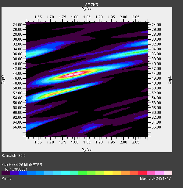
| Thickness Estimate: | 44 km |
| Thickness StdDev: | 2.2 km |
| Vp/Vs Estimate: | 1.80 |
| Vp/Vs StdDev: | 0.02 |
| Vs Estimate: | 3.135 km/s |
| Poisson's Ratio: | 0.27 |
| Peak Value: | 0.04 |
| Assumed Vp: | 5.627 km/s |
| Ps Weight: | 0.33333334 |
| PpPs Weight: | 0.33333334 |
| PsPs Weight: | 0.33333328 |
| Residual Complexity: | 0.587 |
| Nearby stations H: | +- |
| (2.0 deg) Vp/Vs: | +- |
4 with match > 90% ( 18.181818 %) and 20 with match > 80% ( 90.90909 %) out of 22.
Download stack as xyz text file.
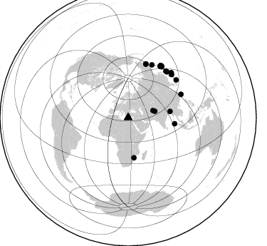
Azimuth Distribution of Events:
Prior Results for this Station
| Study | Thickness | Vp/Vs | Vp | Vs | Poissons Ratio | Extra |
| EARS | 44 km | 1.80 | 5.627 km/s | 3.135 km/s | 0.27 | |
| Crust2.0 | 28 km | 1.82 | 5.627 km/s | 3.087 km/s | 0.28 | S5,continental slope, margin, transition 8 km seds. |
| Global Maxima | 44 km | 1.80 | 5.627 km/s | 3.135 km/s | 0.27 | amp=0.043434747 |
| Local Maxima 1 | 51 km | 1.76 | 5.627 km/s | 3.188 km/s | 0.26 | amp=0.02753773 |
| Local Maxima 2 | 35 km | 2.08 | 5.627 km/s | 2.708 km/s | 0.35 | amp=0.020421289 |
| Local Maxima 3 | 36 km | 1.62 | 5.627 km/s | 3.473 km/s | 0.19 | amp=0.018409349 |
| Local Maxima 4 | 53 km | 1.69 | 5.627 km/s | 3.334 km/s | 0.23 | amp=0.013419975 |
| Predicted Arrivals for vertical incidence (zero ray parameter) | |
| Ps | 6.25 SECOND |
| PpPs | 21.98 SECOND |
| PsPs/PpSs | 28.23 SECOND |
Events Processed for this Station
Download zip of receiver functions as SAC
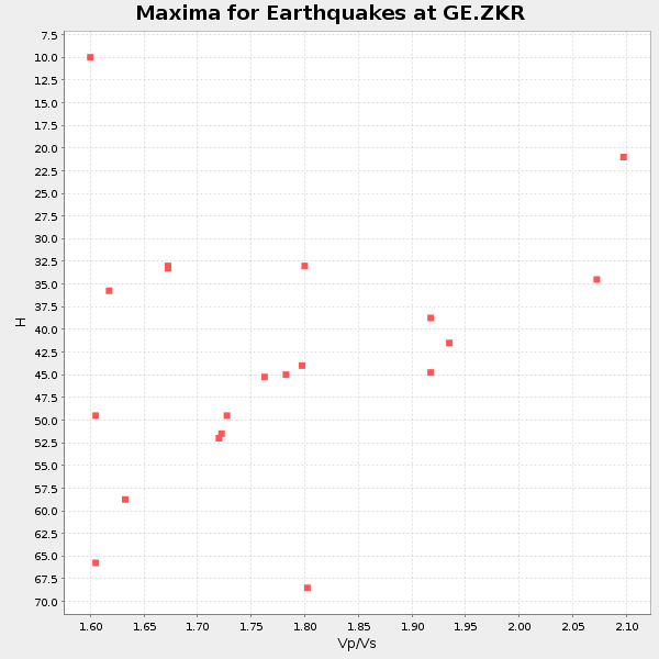
Plot maxima for each earthquake.
Events Used in the Stack
(20 events)| Radial Match | Distance | Baz | FERegion | Time | Lat/Lon | Depth | Magnitude |
| 95.345566 | 85.8 deg | 33.499 deg | Kuril Islands | 2006/11/15 11:14:13 GMT | (46.6, 153.3) | 10 km | 6.5 MB, 7.8 MS, 8.3 MW, 7.9 MW |
| 94.01879 | 79.1 deg | 18.281 deg | Eastern Siberia, Russia | 2006/04/20 23:25:02 GMT | (60.9, 167.1) | 22 km | 6.8 MB, 7.6 MS, 7.6 MW, 7.3 MW |
| 92.78931 | 84.3 deg | 40.191 deg | Hokkaido, Japan Region | 2004/11/28 18:32:14 GMT | (43.0, 145.1) | 39 km | 6.4 MB, 6.7 MS, 7.0 MW, 7.0 MW |
| 91.45433 | 87.6 deg | 43.843 deg | Off East Coast Of Honshu, Japan | 2005/11/14 21:38:51 GMT | (38.1, 144.9) | 11 km | 6.7 MB, 6.8 MS, 7.0 MW, 6.9 MW |
| 89.73714 | 86.6 deg | 33.195 deg | East Of Kuril Islands | 2006/12/07 19:10:21 GMT | (46.2, 154.4) | 16 km | 6.3 MB, 6.1 MS, 6.3 MW, 6.3 MW |
| 89.441086 | 38.6 deg | 76.792 deg | Pakistan | 2005/10/08 03:50:40 GMT | (34.5, 73.6) | 26 km | 6.9 MB, 7.7 MS, 7.6 MW, 7.3 MW |
| 88.651054 | 84.5 deg | 40.212 deg | Hokkaido, Japan Region | 2004/12/06 14:15:11 GMT | (42.9, 145.2) | 35 km | 6.5 MB, 6.5 MS, 6.8 MW, 6.8 MW |
| 88.55352 | 84.3 deg | 39.029 deg | Kuril Islands | 2005/09/21 02:25:08 GMT | (43.9, 146.1) | 103 km | 6.0 MB, 6.1 MW, 6.0 MW |
| 87.27207 | 85.9 deg | 45.261 deg | Near East Coast Of Honshu, Japan | 2005/08/16 02:46:28 GMT | (38.3, 142.0) | 36 km | 6.5 MB, 6.8 MS, 7.2 MW, 7.1 MW |
| 86.42984 | 65.9 deg | 97.477 deg | Nicobar Islands, India Region | 2005/07/24 15:42:06 GMT | (7.9, 92.2) | 16 km | 6.6 MB, 7.5 MS, 7.3 MW, 7.2 MW |
| 85.181656 | 56.6 deg | 171.764 deg | Mozambique | 2006/02/22 22:19:07 GMT | (-21.3, 33.6) | 11 km | 6.5 MB, 7.5 MS, 7.0 MW, 7.0 MW |
| 85.05039 | 86.0 deg | 45.355 deg | Near East Coast Of Honshu, Japan | 2005/12/02 13:13:09 GMT | (38.1, 142.1) | 29 km | 6.1 MB, 6.3 MS, 6.5 MW, 6.4 MW |
| 84.61035 | 84.9 deg | 31.887 deg | Kuril Islands | 2006/11/12 21:27:42 GMT | (48.3, 154.2) | 36 km | 6.1 MB, 5.4 MS, 5.9 MW, 5.9 MW |
| 84.545456 | 85.9 deg | 52.092 deg | Near S. Coast Of Western Honshu | 2004/09/05 10:07:07 GMT | (33.1, 136.6) | 14 km | 6.7 MB, 7.0 MS, 7.2 MW, 7.0 MW |
| 83.726685 | 86.4 deg | 32.035 deg | East Of Kuril Islands | 2006/11/17 06:33:49 GMT | (47.0, 155.5) | 10 km | 5.4 MB, 5.0 MS, 5.6 MW, 5.5 MW |
| 83.659645 | 81.2 deg | 66.297 deg | Taiwan Region | 2004/10/15 04:08:50 GMT | (24.5, 122.7) | 94 km | 6.4 MB, 6.7 MW, 6.6 MW |
| 83.242096 | 81.3 deg | 24.431 deg | Kamchatka Peninsula, Russia | 2004/06/10 15:19:57 GMT | (55.7, 160.0) | 189 km | 6.1 MB, 6.9 MW, 6.9 MW |
| 81.55741 | 79.6 deg | 18.345 deg | Eastern Siberia, Russia | 2006/04/29 16:58:06 GMT | (60.5, 167.5) | 11 km | 6.4 MB, 6.6 MS, 6.6 MW, 6.4 MW |
| 80.650055 | 36.1 deg | 74.414 deg | Afghanistan-Tajikistan Bord Reg. | 2004/04/05 21:24:04 GMT | (36.5, 71.0) | 187 km | 6.4 MB, 6.6 MW, 6.5 MW |
| 80.63709 | 59.6 deg | 81.58 deg | Myanmar-India Border Region | 2006/05/11 17:22:54 GMT | (23.3, 94.3) | 48 km | 5.7 MB, 5.4 MS, 5.4 MW |
Losers
(2 events)| Radial Match | Distance | Baz | FERegion | Time | Lat/Lon | Depth | Magnitude | Reason |
| 65.691505 | 73.3 deg | 99.721 deg | Northern Sumatra, Indonesia | 2005/07/05 01:52:02 GMT | (1.8, 97.1) | 21 km | 6.2 MB, 6.8 MS, 6.7 MW, 6.6 MW | |
| 42.567924 | 78.4 deg | 167.835 deg | Prince Edward Islands Region | 2005/07/04 11:36:05 GMT | (-42.3, 42.4) | 10 km | 5.7 MB, 5.7 MS, 6.3 MW, 6.1 MW |
