
Station GI AVCS - Chisec, Alta Verapax
Network: GI - Red Sismologica Nacional- Guatemala
Nearby stations (2 deg radius)

| Station | Name | (Lat, Lon) | Start / End | Elevation |
| AVCS | Chisec, Alta Verapax | (15.82, -90.28) | 2021-07-14 / 2499-01-01 | 157 m |
| Crust2 Type: | L8,thin continental arc, Cordilleras, 0.5 km seds. |
| Thickness Estimate: | 27 km |
| Thickness StdDev: | 1.5 km |
| Vp/Vs Estimate: | 2.01 |
| Vp/Vs StdDev: | 0.05 |
| Vs Estimate: | 3.263 km/s |
| Poisson's Ratio: | 0.34 |
| Peak Value: | 0.05 |
| Assumed Vp: | 6.566 km/s |
| Ps Weight: | 0.33333334 |
| PpPs Weight: | 0.33333334 |
| PsPs Weight: | 0.33333328 |
| Residual Complexity: | 0.452 |
| Nearby stations H: | +- |
| (2.0 deg) Vp/Vs: | +- |
2 with match > 90% ( 8.333333 %) and 6 with match > 80% ( 25.0 %) out of 24.
Download stack as xyz text file.
Azimuth Distribution of Events:

Prior Results for this Station
| Study | Thickness | Vp/Vs | Vp | Vs | Poissons Ratio | Extra |
| EARS | 27 km | 2.01 | 6.566 km/s | 3.263 km/s | 0.34 | |
| Crust2.0 | 34 km | 1.77 | 6.566 km/s | 3.707 km/s | 0.27 | L8,thin continental arc, Cordilleras, 0.5 km seds. |
| Global Maxima | 27 km | 2.01 | 6.566 km/s | 3.263 km/s | 0.34 | amp=0.045304693 |
| Local Maxima 1 | 37 km | 1.74 | 6.566 km/s | 3.779 km/s | 0.25 | amp=0.018830085 |
| Local Maxima 2 | 25 km | 1.79 | 6.566 km/s | 3.673 km/s | 0.27 | amp=0.012290722 |
| Local Maxima 3 | 49 km | 1.60 | 6.566 km/s | 4.104 km/s | 0.18 | amp=0.011721721 |
| Local Maxima 4 | 70 km | 1.95 | 6.566 km/s | 3.367 km/s | 0.32 | amp=0.007956058 |
| Predicted Arrivals for vertical incidence (zero ray parameter) | |
| Ps | 4.12 SECOND |
| PpPs | 12.27 SECOND |
| PsPs/PpSs | 16.40 SECOND |
Events Processed for this Station
Download zip of receiver functions as SAC
Plot maxima for each earthquake.
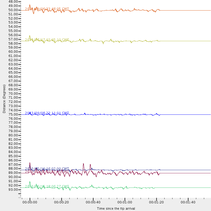
Events Used in the Stack
(6 events)| Radial Match | Distance | Baz | FERegion | Time | Lat/Lon | Depth | Magnitude |
| 94.12134 | 88.9 deg | 253.555 deg | Tonga Islands | 2023/05/10 16:02:00 UTC | (-15.6, -174.6) | 210 km | 7.6 mww |
| 91.942856 | 93.3 deg | 247.187 deg | South Of Fiji Islands | 2023/06/15 18:06:27 UTC | (-23.0, -177.2) | 167 km | 7.2 Mww |
| 88.977486 | 56.9 deg | 161.319 deg | Southern Argentina | 2023/07/17 03:05:10 UTC | (-38.2, -70.4) | 171 km | 6.6 mww |
| 84.128944 | 75.1 deg | 61.451 deg | Morocco | 2023/09/08 22:11:01 UTC | (31.1, -8.4) | 19 km | 6.8 mww |
| 84.08093 | 49.3 deg | 158.479 deg | Near Coast Of Central Chile | 2023/09/06 23:48:05 UTC | (-30.3, -71.5) | 41 km | 6.2 mww |
| 80.75696 | 89.6 deg | 251.389 deg | Tonga Islands | 2023/07/02 10:27:45 UTC | (-17.9, -174.7) | 247 km | 6.7 Mi |
Losers
(18 events)| Radial Match | Distance | Baz | FERegion | Time | Lat/Lon | Depth | Magnitude | Reason |
| 95.94156 | 66.0 deg | 322.969 deg | Alaska Peninsula | 2023/07/16 06:48:21 UTC | (54.5, -160.8) | 21 km | 7.3 Mi | |
| 78.81958 | 97.6 deg | 238.238 deg | South Of Kermadec Islands | 2023/09/08 09:09:58 UTC | (-32.7, -179.3) | 90 km | 6.6 mww | |
| 67.478874 | 52.3 deg | 158.821 deg | Chile-Argentina Border Region | 2023/07/09 17:11:33 UTC | (-33.2, -70.3) | 102 km | 5.6 Mww | |
| 67.26932 | 51.0 deg | 148.873 deg | Santiago Del Estero Prov., Arg. | 2023/08/05 07:20:07 UTC | (-28.2, -63.2) | 598 km | 6.2 Mww | |
| 67.189156 | 36.2 deg | 318.316 deg | Northern California | 2023/05/11 23:19:41 UTC | (40.2, -121.1) | 5.9 km | 5.5 Mw | |
| 62.971066 | 45.2 deg | 154.465 deg | Near Coast Of Northern Chile | 2023/05/07 06:29:00 UTC | (-25.4, -70.5) | 40 km | 5.2 Mww | |
| 58.82079 | 76.2 deg | 197.363 deg | Southern East Pacific Rise | 2023/05/08 06:02:16 UTC | (-56.1, -121.4) | 10 km | 5.8 Mww | |
| 58.650158 | 83.7 deg | 325.057 deg | Komandorskiye Ostrova Region | 2023/08/01 16:49:49 UTC | (54.7, 168.2) | 11 km | 5.7 Mww | |
| 58.203236 | 87.0 deg | 252.898 deg | Samoa Islands Region | 2023/05/02 14:24:59 UTC | (-15.7, -172.5) | 35 km | 5.5 mww | |
| 56.477707 | 92.7 deg | 245.342 deg | South Of Fiji Islands | 2023/08/16 16:00:22 UTC | (-24.6, -176.0) | 29 km | 5.5 Mww | |
| 54.384342 | 69.7 deg | 319.664 deg | Fox Islands, Aleutian Islands | 2023/08/20 01:48:54 UTC | (51.6, -167.3) | 10 km | 5.2 Mww | |
| 52.362965 | 45.1 deg | 150.575 deg | Chile-Argentina Border Region | 2023/07/06 00:31:55 UTC | (-23.9, -67.9) | 132 km | 5.8 mww | |
| 50.743576 | 91.4 deg | 254.551 deg | Fiji Islands Region | 2023/06/23 23:05:52 UTC | (-15.3, -177.3) | 9.2 km | 5.5 mww | |
| 47.177315 | 92.3 deg | 246.289 deg | Tonga Islands Region | 2023/06/16 08:11:34 UTC | (-23.6, -175.9) | 22 km | 6.0 mww | |
| 47.058395 | 93.3 deg | 138.281 deg | Southern Mid-Atlantic Ridge | 2023/06/09 20:43:28 UTC | (-47.3, -12.7) | 10 km | 5.5 mb | |
| 45.557476 | 49.9 deg | 148.072 deg | Santiago Del Estero Prov., Arg. | 2023/08/23 14:22:43 UTC | (-26.9, -63.3) | 569 km | 6.2 mww | |
| 38.679317 | 80.0 deg | 106.432 deg | Southern Mid-Atlantic Ridge | 2023/06/21 04:10:53 UTC | (-12.9, -14.7) | 10 km | 5.5 mww | |
| 34.036255 | 94.8 deg | 249.022 deg | Fiji Islands Region | 2023/08/02 01:32:35 UTC | (-21.6, -179.3) | 632 km | 5.8 mww |

